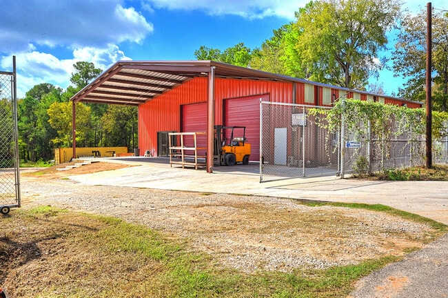
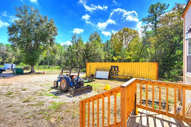
Property Record
28908 Richard Kaye Ln, Pinehurst, TX 77362

Current Lease Availabilities
Property Detail
28908 Richard Kaye Ln
0364-00-00375
A0364 MOORE JOHN, TRACT 3 LOT 12, ACRES 2.040
Commercialnec
Montgomery
2
Texas
AE The base floodplain where base flood elevations are provided. AE Zones are now used on new format FIRMs instead of A1-A30 Zones.
12
2024
2.04 AC
2025
The Woodlands/Conroe
690405
Houston
4,016 SF
Houston-Pasadena-The Woodlands, TX
NEARBY LISTINGS FOR SALE OR LEASE
DEMOGRAPHICS near 28908 Richard Kaye Ln
1 mile
3 mile
5 mile
2025 Total Population
2,545
24,994
74,966
2030 Population
2,933
28,441
84,901
Pop Growth 2025-2030
+ 15.25%
+ 13.79%
+ 13.25%
Average Age
36
40
38
2025 Total Households
857
9,030
26,330
HH Growth 2025-2030
+ 15.52%
+ 13.80%
+ 13.41%
Median Household Inc
$84,932
$97,919
$102,065
Avg Household Size
2.90
2.70
2.80
2025 Avg HH Vehicles
2.00
2.00
2.00
Median Home Value
$284,262
$379,180
$400,018
Median Year Built
2006
2002
2010
Nearby Places
Map Layers
Map Styles
 Street
 Aerial
Layers
 Traffic
 Biking
Places
Listings with unknown addresses are not visible on the map
- Restaurants
- Banks
- Shops
- Fitness
- Groceries
PUBLIC TRANSPORTATION
AIRPORT
George Bush Intcntl/Houston
Drive
Walk
Distance
George Bush Intcntl/Houston
43 min
32.2 mi
Freight Ports
Port of Houston
Drive
Walk
Distance
Port of Houston
63 min
42.8 mi
Nearby Properties
Address
Land Use
TOTAL SIZE
Lot Size
Zoning
Address
Land Use
TOTAL SIZE
Lot Size
Zoning
179,083 SF
8.29 AC
Address
Land Use
TOTAL SIZE
Lot Size
Zoning
110,553 SF
10.34 AC
Address
Land Use
TOTAL SIZE
Lot Size
Zoning
176,180 SF
7.28 AC
Address
Land Use
TOTAL SIZE
Lot Size
Zoning
146,990 SF
7.02 AC
Address
Land Use
TOTAL SIZE
Lot Size
Zoning
59,119 SF
6.26 AC
Address
Land Use
TOTAL SIZE
Lot Size
Zoning
112,854 SF
5.80 AC
Address
Land Use
TOTAL SIZE
Lot Size
Zoning
118,004 SF
5.55 AC
Address
Land Use
TOTAL SIZE
Lot Size
Zoning
88,950 SF
12.24 AC
Address
Land Use
TOTAL SIZE
Lot Size
Zoning
135,804 SF
15.33 AC
Address
Land Use
TOTAL SIZE
Lot Size
Zoning
65,475 SF
7.84 AC
Address
Land Use
TOTAL SIZE
Lot Size
Zoning
104,859 SF
5.29 AC
Address
Land Use
TOTAL SIZE
Lot Size
Zoning
54,323 SF
3.66 AC
Address
Land Use
TOTAL SIZE
Lot Size
Zoning
73,992 SF
7.21 AC
Address
Land Use
TOTAL SIZE
Lot Size
Zoning
122,970 SF
11.79 AC
Address
Land Use
TOTAL SIZE
Lot Size
Zoning
81,277 SF
4.43 AC
Address
Land Use
TOTAL SIZE
Lot Size
Zoning
41,541 SF
3.93 AC
Address
Land Use
TOTAL SIZE
Lot Size
Zoning
43,105 SF
51.54 AC
2
Address
Land Use
TOTAL SIZE
Lot Size
Zoning
24,483 SF
9.66 AC
Address
Land Use
TOTAL SIZE
Lot Size
Zoning
14,865 SF
1.98 AC
2
Address
Land Use
TOTAL SIZE
Lot Size
Zoning
65,600 SF
4.99 AC
Address
Land Use
TOTAL SIZE
Lot Size
Zoning
90,311 SF
10 AC
Address
Land Use
TOTAL SIZE
Lot Size
Zoning
34,952 SF
5.87 AC
Address
Land Use
TOTAL SIZE
Lot Size
Zoning
7,800 SF
18.47 AC
Address
Land Use
TOTAL SIZE
Lot Size
Zoning
100,389 SF
5.47 AC
2
Address
Land Use
TOTAL SIZE
Lot Size
Zoning
66,333 SF
4.49 AC
Address
Land Use
TOTAL SIZE
Lot Size
Zoning
71,616 SF
4.74 AC
Address
Land Use
TOTAL SIZE
Lot Size
Zoning
Address
Land Use
TOTAL SIZE
Lot Size
Zoning
48,896 SF
2 AC
Address
Land Use
TOTAL SIZE
Lot Size
Zoning
16,260 SF
3.24 AC
2
Address
Land Use
TOTAL SIZE
Lot Size
Zoning
10,946 SF
0.91 AC
The World's #1 Commercial Real Estate Marketplace
Connect with us
© 2026 CoStar Group
The information above has been obtained from sources believed reliable. While we do not doubt its accuracy we have not verified it and make no guarantee, warranty or representation about it. It is your responsibility to independently confirm its accuracy and completeness. Any projections, opinions, assumptions, or estimates used are for example only and do not represent the current or future performance of the property. The value of this transaction to you depends on tax and other factors which should be evaluated by your tax, financial, and legal advisors. You and your advisors should conduct a careful, independent investigation of the property to determine to your satisfaction the suitability of the property for your needs.