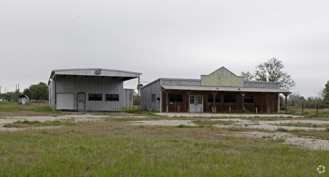
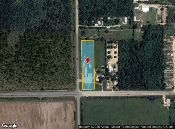
Property Record
28922 Fm 2920 Rd, Waller, TX 77484

NEARBY LISTINGS FOR SALE OR LEASE
Property Detail
28922 Fm 2920 Rd
Houston-Pasadena-The Woodlands, TX
Madison Square U/R
1150400010001
LT 1 BLK 1 MADISON SQUARE U/R
Storebuilding
Harris
X
Texas
48339C0650G
1
2024
2 AC
2025
Northwest Hwy 6
556000
Houston
3,600 SF
DEMOGRAPHICS near 28922 Fm 2920 Rd
1 Mile
3 Mile
5 Mile
2024 Total Population
369
3,540
11,279
2029 Population
355
3,635
12,616
Pop Growth 2024-2029
(3.79%)
+ 2.68%
+ 11.85%
Average Age
38
37
36
2024 Total Households
130
1,217
3,848
HH Growth 2024-2029
(3.85%)
+ 2.63%
+ 12.47%
Median Household Inc
$45,833
$40,263
$53,816
Avg Household Size
2.90
2.90
2.90
2024 Avg HH Vehicles
3.00
2.00
2.00
Median Home Value
$544,643
$324,285
$268,238
Median Year Built
1996
2000
1997
Nearby Places
Map Layers
Map Styles
 Street
 Aerial
- Restaurants
- Banks
- Shops
- Fitness
- Groceries
Nearby Properties
Address
Land Use
TOTAL SIZE
Lot Size
Zoning
Address
Land Use
TOTAL SIZE
Lot Size
Zoning
283.61 AC
Address
Land Use
TOTAL SIZE
Lot Size
Zoning
512,325 SF
63.88 AC
Address
Land Use
TOTAL SIZE
Lot Size
Zoning
463,544 SF
31.14 AC
Address
Land Use
TOTAL SIZE
Lot Size
Zoning
496,333 SF
86.70 AC
Address
Land Use
TOTAL SIZE
Lot Size
Zoning
189,034 SF
9.49 AC
Address
Land Use
TOTAL SIZE
Lot Size
Zoning
1,463.22 AC
Address
Land Use
TOTAL SIZE
Lot Size
Zoning
474.77 AC
Address
Land Use
TOTAL SIZE
Lot Size
Zoning
68,500 SF
16.73 AC
Address
Land Use
TOTAL SIZE
Lot Size
Zoning
164.11 AC
Address
Land Use
TOTAL SIZE
Lot Size
Zoning
17,400 SF
21.16 AC
Address
Land Use
TOTAL SIZE
Lot Size
Zoning
77,880 SF
20 AC
Address
Land Use
TOTAL SIZE
Lot Size
Zoning
337.84 AC
Address
Land Use
TOTAL SIZE
Lot Size
Zoning
283.44 AC
Address
Land Use
TOTAL SIZE
Lot Size
Zoning
69,623 SF
10 AC
Address
Land Use
TOTAL SIZE
Lot Size
Zoning
860.08 AC
Address
Land Use
TOTAL SIZE
Lot Size
Zoning
Address
Land Use
TOTAL SIZE
Lot Size
Zoning
105 AC
Address
Land Use
TOTAL SIZE
Lot Size
Zoning
467.86 AC
Address
Land Use
TOTAL SIZE
Lot Size
Zoning
30,748 SF
17.20 AC
Address
Land Use
TOTAL SIZE
Lot Size
Zoning
48,648 SF
2.25 AC
Address
Land Use
TOTAL SIZE
Lot Size
Zoning
175 AC
Address
Land Use
TOTAL SIZE
Lot Size
Zoning
68.28 AC
Address
Land Use
TOTAL SIZE
Lot Size
Zoning
120.20 AC
Address
Land Use
TOTAL SIZE
Lot Size
Zoning
152.84 AC
Address
Land Use
TOTAL SIZE
Lot Size
Zoning
127.53 AC
Address
Land Use
TOTAL SIZE
Lot Size
Zoning
8,827 SF
8.45 AC
Address
Land Use
TOTAL SIZE
Lot Size
Zoning
162.19 AC
Address
Land Use
TOTAL SIZE
Lot Size
Zoning
44,031 SF
2.40 AC
Address
Land Use
TOTAL SIZE
Lot Size
Zoning
101.59 AC
Address
Land Use
TOTAL SIZE
Lot Size
Zoning
69,560 SF
13.54 AC
The World's #1 Commercial Real Estate Marketplace
Connect with us
© 2026 CoStar Group
The information above has been obtained from sources believed reliable. While we do not doubt its accuracy we have not verified it and make no guarantee, warranty or representation about it. It is your responsibility to independently confirm its accuracy and completeness. Any projections, opinions, assumptions, or estimates used are for example only and do not represent the current or future performance of the property. The value of this transaction to you depends on tax and other factors which should be evaluated by your tax, financial, and legal advisors. You and your advisors should conduct a careful, independent investigation of the property to determine to your satisfaction the suitability of the property for your needs.