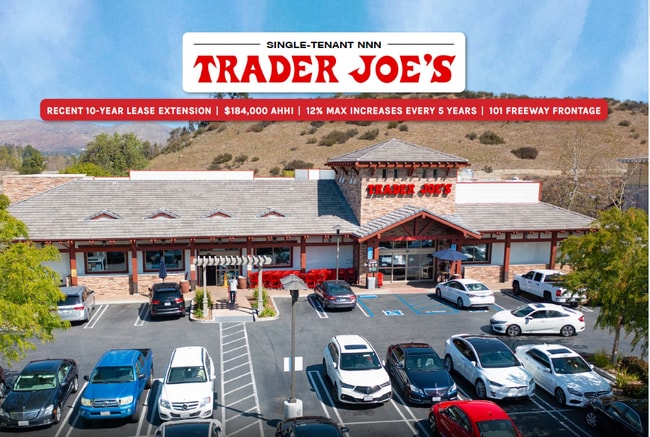
Property Record
28941 Canwood St, West Hills, CA 91307

NEARBY LISTINGS FOR SALE OR LEASE
Property Detail
28941 Canwood St
Los Angeles-Long Beach-Glendale, CA
53752
2048-011-077
TR=53752 FOR DESC SEE ASSESSORS MAPS POR OF LOTS 6,7 AND C
Storemultistory
Los Angeles
X
California
06111C0995E
6,7
2024
1.25 AC
2025
Calabasas/Westlake Vill
134422
Los Angeles
12,809 SF
DEMOGRAPHICS near 28941 Canwood St
1 Mile
3 Mile
5 Mile
2024 Total Population
7,543
37,154
69,873
2029 Population
7,310
36,079
68,132
Pop Growth 2024-2029
(3.09%)
(2.89%)
(2.49%)
Average Age
43
43
44
2024 Total Households
2,858
13,795
27,068
HH Growth 2024-2029
(3.25%)
(3.07%)
(2.65%)
Median Household Inc
$121,277
$145,491
$140,631
Avg Household Size
2.60
2.70
2.60
2024 Avg HH Vehicles
2.00
2.00
2.00
Median Home Value
$894,474
$911,614
$1,001,481
Median Year Built
1980
1982
1981
Nearby Places
Map Layers
Map Styles
 Street
 Aerial
- Restaurants
- Banks
- Shops
- Fitness
- Groceries
PUBLIC TRANSPORTATION
AIRPORT
Bob Hope
DRIVE
WALK
Distance
Bob Hope
38 min
27.7 mi
Los Angeles International
DRIVE
WALK
Distance
Los Angeles International
48 min
35.8 mi
SALE & LEASE HISTORY
LISTING DATE
SALE/LEASE

Oct 01, 2020
For Sale
Nov 04, 2023
For Sale
Jun 15, 2021
For Sale
Jun 06, 2025
For Sale
Aug 21, 2024
For Sale
Aug 04, 2021
For Sale
Apr 07, 2021
For Sale
Nearby Properties
Address
Land Use
TOTAL SIZE
Lot Size
Zoning
Address
Land Use
TOTAL SIZE
Lot Size
Zoning
676,545 SF
19.76 AC
WVM1*
Address
Land Use
TOTAL SIZE
Lot Size
Zoning
142,150 SF
15.35 AC
AH SP*
Address
Land Use
TOTAL SIZE
Lot Size
Zoning
736,464 SF
19.64 AC
WVM1*
Address
Land Use
TOTAL SIZE
Lot Size
Zoning
163,773 SF
5.80 AC
Address
Land Use
TOTAL SIZE
Lot Size
Zoning
142,738 SF
5.56 AC
AH BP-M-FC
Address
Land Use
TOTAL SIZE
Lot Size
Zoning
168,729 SF
10.21 AC
WVM1*
Address
Land Use
TOTAL SIZE
Lot Size
Zoning
142,578 SF
6.13 AC
Address
Land Use
TOTAL SIZE
Lot Size
Zoning
169,597 SF
7.19 AC
AH SP*
Address
Land Use
TOTAL SIZE
Lot Size
Zoning
116,906 SF
6.35 AC
LCA21*
Address
Land Use
TOTAL SIZE
Lot Size
Zoning
201,223 SF
6.94 AC
LCA21*
Address
Land Use
TOTAL SIZE
Lot Size
Zoning
138,762 SF
8.69 AC
LCA21*
Address
Land Use
TOTAL SIZE
Lot Size
Zoning
110,229 SF
5.31 AC
CSCB
Address
Land Use
TOTAL SIZE
Lot Size
Zoning
230,800 SF
4.39 AC
LCMP
Address
Land Use
TOTAL SIZE
Lot Size
Zoning
98,127 SF
2.56 AC
AHRA20000*
Address
Land Use
TOTAL SIZE
Lot Size
Zoning
230,960 SF
6.99 AC
WVM1*
Address
Land Use
TOTAL SIZE
Lot Size
Zoning
115,790 SF
5.41 AC
WVM1*
Address
Land Use
TOTAL SIZE
Lot Size
Zoning
86,558 SF
8.83 AC
AHC3*
Address
Land Use
TOTAL SIZE
Lot Size
Zoning
117,968 SF
6.19 AC
AH BP-M-FC
Address
Land Use
TOTAL SIZE
Lot Size
Zoning
71,159 SF
5.74 AC
AH BP-OR-F
Address
Land Use
TOTAL SIZE
Lot Size
Zoning
65,546 SF
4.08 AC
LCA21*
Address
Land Use
TOTAL SIZE
Lot Size
Zoning
191,936 SF
11.59 AC
RPD-19-
Address
Land Use
TOTAL SIZE
Lot Size
Zoning
94,555 SF
3.28 AC
CRS
Address
Land Use
TOTAL SIZE
Lot Size
Zoning
137,738 SF
10.29 AC
LCA21*
Address
Land Use
TOTAL SIZE
Lot Size
Zoning
69,148 SF
3.08 AC
LCA21*
Address
Land Use
TOTAL SIZE
Lot Size
Zoning
157,896 SF
5.74 AC
AH
Address
Land Use
TOTAL SIZE
Lot Size
Zoning
58,092 SF
3.95 AC
AHCRS-FC-O
Address
Land Use
TOTAL SIZE
Lot Size
Zoning
113,871 SF
2.24 AC
LCA21*
Address
Land Use
TOTAL SIZE
Lot Size
Zoning
50,220 SF
4.62 AC
LCA2
Address
Land Use
TOTAL SIZE
Lot Size
Zoning
120,006 SF
6.30 AC
AH BP-M-FC
Address
Land Use
TOTAL SIZE
Lot Size
Zoning
215,232 SF
18.99 AC
AH BP-M-FC
The World's #1 Commercial Real Estate Marketplace
Connect with us
© 2026 CoStar Group
The information above has been obtained from sources believed reliable. While we do not doubt its accuracy we have not verified it and make no guarantee, warranty or representation about it. It is your responsibility to independently confirm its accuracy and completeness. Any projections, opinions, assumptions, or estimates used are for example only and do not represent the current or future performance of the property. The value of this transaction to you depends on tax and other factors which should be evaluated by your tax, financial, and legal advisors. You and your advisors should conduct a careful, independent investigation of the property to determine to your satisfaction the suitability of the property for your needs.