Property Record
2895 Braeburn Cir, Ann Arbor, MI 48108

NEARBY LISTINGS FOR SALE OR LEASE
-
-
View all Ann Arbor listings for sale on LoopNet.com
Property Detail
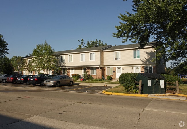
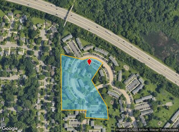
2895 Braeburn Cir
12-10-401-005
Washtenaw Estates
Commercialnec
PRT SE 1/4 SEC 10 T3S R6E COM S 1/4 COR SEC 10 TH N 0 DEG 35 MIN W 1483.66 FT FOR POB TH N 0 DEG 35 MIN W 550 FT TH S 78 DEG
X
Washtenaw
26161C0402E
Michigan
2025
4.90 AC
2025
Bryant
405600
Detroit
55,236 SF
Ann Arbor, MI
DEMOGRAPHICS near 2895 Braeburn Cir
1 Mile
3 Mile
5 Mile
2024 Total Population
9,162
66,425
177,452
2029 Population
8,983
65,458
175,472
Pop Growth 2024-2029
(1.95%)
(1.46%)
(1.12%)
Average Age
38
38
36
2024 Total Households
4,050
29,754
73,016
HH Growth 2024-2029
(2.02%)
(1.56%)
(1.14%)
Median Household Inc
$53,289
$72,906
$69,090
Avg Household Size
2.20
2.10
2.10
2024 Avg HH Vehicles
1.00
2.00
2.00
Median Home Value
$237,207
$331,455
$380,676
Median Year Built
1972
1978
1975
Nearby Places
Map Layers
Map Styles
 Street
 Aerial
- Restaurants
- Banks
- Shops
- Fitness
- Groceries
PUBLIC TRANSPORTATION
COMMUTER RAIL
Ann Arbor Amtrak Station (Wolverine - Amtrak)
DRIVE
WALK
Distance
Ann Arbor Amtrak Station (Wolverine - Amtrak)
14 min
6.0 mi
AIRPORT
Detroit Metro Wayne County
DRIVE
WALK
Distance
Detroit Metro Wayne County
32 min
22.4 mi
Freight Ports
Port of Toledo
DRIVE
WALK
Distance
Port of Toledo
73 min
55.5 mi
Nearby Properties
Address
Land Use
TOTAL SIZE
Lot Size
Zoning
Address
Land Use
TOTAL SIZE
Lot Size
Zoning
235,070 SF
0.80 AC
D1
Address
Land Use
TOTAL SIZE
Lot Size
Zoning
407,374 SF
35.17 AC
C3
Address
Land Use
TOTAL SIZE
Lot Size
Zoning
Address
Land Use
TOTAL SIZE
Lot Size
Zoning
315,108 SF
6.57 AC
C1B
Address
Land Use
TOTAL SIZE
Lot Size
Zoning
334,077 SF
20.41 AC
R4B
Address
Land Use
TOTAL SIZE
Lot Size
Zoning
36,000 SF
27.61 AC
BI
Address
Land Use
TOTAL SIZE
Lot Size
Zoning
357,978 SF
19.32 AC
R4B
Address
Land Use
TOTAL SIZE
Lot Size
Zoning
112,994 SF
45.12 AC
IH
Address
Land Use
TOTAL SIZE
Lot Size
Zoning
140,039 SF
Address
Land Use
TOTAL SIZE
Lot Size
Zoning
127,076 SF
0.39 AC
D1
Address
Land Use
TOTAL SIZE
Lot Size
Zoning
214,559 SF
16.18 AC
PUD
Address
Land Use
TOTAL SIZE
Lot Size
Zoning
37,500 SF
25.94 AC
BI
Address
Land Use
TOTAL SIZE
Lot Size
Zoning
125,073 SF
0.26 AC
D1
Address
Land Use
TOTAL SIZE
Lot Size
Zoning
253,702 SF
30.23 AC
Address
Land Use
TOTAL SIZE
Lot Size
Zoning
1.19 AC
R4C
Address
Land Use
TOTAL SIZE
Lot Size
Zoning
17,672 SF
33.37 AC
BI
Address
Land Use
TOTAL SIZE
Lot Size
Zoning
361,634 SF
17.09 AC
Address
Land Use
TOTAL SIZE
Lot Size
Zoning
32,040 SF
22.33 AC
BI
Address
Land Use
TOTAL SIZE
Lot Size
Zoning
27,603 SF
35.42 AC
BI
Address
Land Use
TOTAL SIZE
Lot Size
Zoning
111,435 SF
21.38 AC
R4B
Address
Land Use
TOTAL SIZE
Lot Size
Zoning
175,536 SF
12.98 AC
R4B
Address
Land Use
TOTAL SIZE
Lot Size
Zoning
119,631 SF
7.85 AC
PUD
Address
Land Use
TOTAL SIZE
Lot Size
Zoning
13,720 SF
37.87 AC
Address
Land Use
TOTAL SIZE
Lot Size
Zoning
88,460 SF
28.50 AC
DI
Address
Land Use
TOTAL SIZE
Lot Size
Zoning
192,726 SF
6.45 AC
O
Address
Land Use
TOTAL SIZE
Lot Size
Zoning
283,290 SF
10.42 AC
O
Address
Land Use
TOTAL SIZE
Lot Size
Zoning
480 SF
23.64 AC
BI
Address
Land Use
TOTAL SIZE
Lot Size
Zoning
137,182 SF
11.83 AC
R4C
Address
Land Use
TOTAL SIZE
Lot Size
Zoning
317,872 SF
11.79 AC
M1
Address
Land Use
TOTAL SIZE
Lot Size
Zoning
94,157 SF
7.20 AC
C3
The World's #1 Commercial Real Estate Marketplace
Connect with us
© 2025 CoStar Group
The information above has been obtained from sources believed reliable. While we do not doubt its accuracy we have not verified it and make no guarantee, warranty or representation about it. It is your responsibility to independently confirm its accuracy and completeness. Any projections, opinions, assumptions, or estimates used are for example only and do not represent the current or future performance of the property. The value of this transaction to you depends on tax and other factors which should be evaluated by your tax, financial, and legal advisors. You and your advisors should conduct a careful, independent investigation of the property to determine to your satisfaction the suitability of the property for your needs.