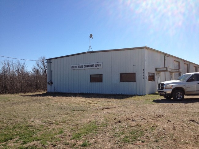
Property Record
2895 E Us Highway 80, Abilene, TX 79601

Property Detail
2895 E Us Highway 80
Abilene, TX
WILLIAM H VARNER SUB, BLOCK 1, LOT PT OF 3, ACRES 2.92
21651
Taylor
Multipleuses
Texas
A Areas with a 1% annual chance of flooding and a 26% chance of flooding over the life of a 30-year mortgage.
3
2024
2.92 AC
2025
Abilene
013404
Other Market Areas
6,000 SF
NEARBY LISTINGS FOR SALE OR LEASE
DEMOGRAPHICS near 2895 E Us Highway 80
1 mile
3 mile
5 mile
2025 Total Population
28
15,562
54,575
2030 Population
29
16,142
56,794
Pop Growth 2025-2030
+ 3.57%
+ 3.73%
+ 4.07%
Average Age
40
37
37
2025 Total Households
9
5,906
20,415
HH Growth 2025-2030
0.00%
+ 3.73%
+ 4.24%
Median Household Inc
$83,333
$55,742
$53,235
Avg Household Size
2.50
2.20
2.40
2025 Avg HH Vehicles
2.00
2.00
2.00
Median Home Value
$274,999
$240,198
$153,939
Median Year Built
1982
1984
1965
Nearby Places
Map Layers
Map Styles
 Street
 Aerial
Transit
 Traffic
 Biking
Places
Listings with unknown addresses are not visible on the map
- Restaurants
- Banks
- Shops
- Fitness
- Groceries
PUBLIC TRANSPORTATION
AIRPORT
Abilene Regional
Drive
Walk
Distance
Abilene Regional
7 min
3.3 mi
SALE & LEASE HISTORY
LISTING DATE
SALE/LEASE

Mar 31, 2017
For Lease
Aug 22, 2025
For Lease
Nearby Properties
Address
Land Use
TOTAL SIZE
Lot Size
Zoning
Address
Land Use
TOTAL SIZE
Lot Size
Zoning
812,955 SF
99.27 AC
Address
Land Use
TOTAL SIZE
Lot Size
Zoning
241,730 SF
51.89 AC
Address
Land Use
TOTAL SIZE
Lot Size
Zoning
283,878 SF
76.01 AC
Address
Land Use
TOTAL SIZE
Lot Size
Zoning
411,104 SF
91.21 AC
Address
Land Use
TOTAL SIZE
Lot Size
Zoning
325,355 SF
9.83 AC
Address
Land Use
TOTAL SIZE
Lot Size
Zoning
115,568 SF
23.57 AC
Address
Land Use
TOTAL SIZE
Lot Size
Zoning
212,450 SF
9.43 AC
Address
Land Use
TOTAL SIZE
Lot Size
Zoning
108,121 SF
15 AC
Address
Land Use
TOTAL SIZE
Lot Size
Zoning
58,988 SF
1,463.70 AC
Address
Land Use
TOTAL SIZE
Lot Size
Zoning
166,224 SF
8.79 AC
Address
Land Use
TOTAL SIZE
Lot Size
Zoning
88,656 SF
4.14 AC
Address
Land Use
TOTAL SIZE
Lot Size
Zoning
67,593 SF
49.82 AC
Address
Land Use
TOTAL SIZE
Lot Size
Zoning
209,580 SF
20.94 AC
Address
Land Use
TOTAL SIZE
Lot Size
Zoning
130,048 SF
8.22 AC
Address
Land Use
TOTAL SIZE
Lot Size
Zoning
101,812 SF
6.28 AC
Address
Land Use
TOTAL SIZE
Lot Size
Zoning
60,944 SF
2.86 AC
Address
Land Use
TOTAL SIZE
Lot Size
Zoning
4,500 SF
18.85 AC
Address
Land Use
TOTAL SIZE
Lot Size
Zoning
54,844 SF
12.70 AC
Address
Land Use
TOTAL SIZE
Lot Size
Zoning
108,695 SF
4 AC
Address
Land Use
TOTAL SIZE
Lot Size
Zoning
67,823 SF
14.89 AC
Address
Land Use
TOTAL SIZE
Lot Size
Zoning
234,447 SF
19.56 AC
Address
Land Use
TOTAL SIZE
Lot Size
Zoning
41,585 SF
165.35 AC
Address
Land Use
TOTAL SIZE
Lot Size
Zoning
80,210 SF
2.70 AC
Address
Land Use
TOTAL SIZE
Lot Size
Zoning
50.83 AC
Address
Land Use
TOTAL SIZE
Lot Size
Zoning
114,910 SF
8.44 AC
Address
Land Use
TOTAL SIZE
Lot Size
Zoning
70,241 SF
5.95 AC
Address
Land Use
TOTAL SIZE
Lot Size
Zoning
139,673 SF
14.49 AC
Address
Land Use
TOTAL SIZE
Lot Size
Zoning
260,902 SF
16.13 AC
Address
Land Use
TOTAL SIZE
Lot Size
Zoning
44,803 SF
5.63 AC
Address
Land Use
TOTAL SIZE
Lot Size
Zoning
31,813 SF
12.01 AC
The World's #1 Commercial Real Estate Marketplace
Connect with us
© 2026 CoStar Group
The information above has been obtained from sources believed reliable. While we do not doubt its accuracy we have not verified it and make no guarantee, warranty or representation about it. It is your responsibility to independently confirm its accuracy and completeness. Any projections, opinions, assumptions, or estimates used are for example only and do not represent the current or future performance of the property. The value of this transaction to you depends on tax and other factors which should be evaluated by your tax, financial, and legal advisors. You and your advisors should conduct a careful, independent investigation of the property to determine to your satisfaction the suitability of the property for your needs.