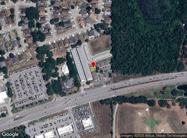
Property Record
28951 State Road 54 Blvd, Wesley Chapel, FL 33543


Current Lease Availabilities
NEARBY LISTINGS FOR SALE OR LEASE
Property Detail
28951 State Road 54 Blvd
Tampa-St. Petersburg-Clearwater, FL
Villages At Wesley Chapel
07-26-20-0000-00100-0089
COM AT NE COR OF SEC 7 ALSO BEING NE COR OF VILLAGES AT WESLEY CHAPEL PHASE 2B PB 30 PG 117-119 TH S00DEG 29 28W 1156.63 FT TH S71DEG 41 56W 228.95 FT FOR POB TH S18DEG 18 04E 14.00 FT TH N71DEG 41 56E 3.00 FT TH S18DEG 18 04E 12.00 FT TH S71DEG41 56
Officebuilding
Pasco
X
Florida
12101C0427F
89
2024
0.05 AC
2025
Pasco County
032104
Tampa/St Petersburg
1,980 SF
DEMOGRAPHICS near 28951 State Road 54 Blvd
1 Mile
3 Mile
5 Mile
2024 Total Population
3,946
41,309
96,720
2029 Population
4,829
50,241
117,335
Pop Growth 2024-2029
+ 22.38%
+ 21.62%
+ 21.31%
Average Age
40
38
38
2024 Total Households
1,389
13,940
33,712
HH Growth 2024-2029
+ 22.25%
+ 21.56%
+ 21.22%
Median Household Inc
$98,903
$102,152
$101,201
Avg Household Size
2.80
2.90
2.80
2024 Avg HH Vehicles
2.00
2.00
2.00
Median Home Value
$348,067
$317,107
$308,827
Median Year Built
2001
2005
2005
Nearby Places
- Restaurants
- Banks
- Shops
- Fitness
- Groceries
PUBLIC TRANSPORTATION
AIRPORT
Tampa International
DRIVE
WALK
Distance
Tampa International
42 min
29.8 mi
St Pete-Clearwater International
DRIVE
WALK
Distance
St Pete-Clearwater International
59 min
39.8 mi
Nearby Properties
Address
Land Use
TOTAL SIZE
Lot Size
Zoning
Address
Land Use
TOTAL SIZE
Lot Size
Zoning
435,775 SF
138.45 AC
AR
Address
Land Use
TOTAL SIZE
Lot Size
Zoning
306,559 SF
34.59 AC
MPUD
Address
Land Use
TOTAL SIZE
Lot Size
Zoning
343,155 SF
23.92 AC
MPUD
Address
Land Use
TOTAL SIZE
Lot Size
Zoning
398,092 SF
22.48 AC
MPUD
Address
Land Use
TOTAL SIZE
Lot Size
Zoning
319,575 SF
19.80 AC
MPUD
Address
Land Use
TOTAL SIZE
Lot Size
Zoning
315,343 SF
20.80 AC
MPUD
Address
Land Use
TOTAL SIZE
Lot Size
Zoning
267,326 SF
22.50 AC
MPUD
Address
Land Use
TOTAL SIZE
Lot Size
Zoning
275,549 SF
16.24 AC
C2
Address
Land Use
TOTAL SIZE
Lot Size
Zoning
418,644 SF
105.51 AC
AR
Address
Land Use
TOTAL SIZE
Lot Size
Zoning
241,371 SF
11.48 AC
MPUD
Address
Land Use
TOTAL SIZE
Lot Size
Zoning
50,016 SF
14.04 AC
MPUD
Address
Land Use
TOTAL SIZE
Lot Size
Zoning
244,355 SF
70.12 AC
MPUD
Address
Land Use
TOTAL SIZE
Lot Size
Zoning
153,412 SF
9.77 AC
MPUD
Address
Land Use
TOTAL SIZE
Lot Size
Zoning
146,401 SF
17.78 AC
MPUD
Address
Land Use
TOTAL SIZE
Lot Size
Zoning
142,552 SF
5.69 AC
MPUD
Address
Land Use
TOTAL SIZE
Lot Size
Zoning
115,596 SF
3.83 AC
C2
Address
Land Use
TOTAL SIZE
Lot Size
Zoning
106,926 SF
89.04 AC
MPUD
Address
Land Use
TOTAL SIZE
Lot Size
Zoning
86,782 SF
12.21 AC
C2
Address
Land Use
TOTAL SIZE
Lot Size
Zoning
28,631 SF
8.84 AC
MPUD
Address
Land Use
TOTAL SIZE
Lot Size
Zoning
91,866 SF
2.70 AC
MPUD
Address
Land Use
TOTAL SIZE
Lot Size
Zoning
109,440 SF
3.28 AC
C2
Address
Land Use
TOTAL SIZE
Lot Size
Zoning
189,610 SF
13.68 AC
MPUD
Address
Land Use
TOTAL SIZE
Lot Size
Zoning
106,061 SF
14.01 AC
MPUD
Address
Land Use
TOTAL SIZE
Lot Size
Zoning
38,392 SF
9.54 AC
MPUD
Address
Land Use
TOTAL SIZE
Lot Size
Zoning
6.13 AC
MPUD
Address
Land Use
TOTAL SIZE
Lot Size
Zoning
210,354 SF
29.03 AC
C2
Address
Land Use
TOTAL SIZE
Lot Size
Zoning
118,112 SF
10.41 AC
MF1
Address
Land Use
TOTAL SIZE
Lot Size
Zoning
90,759 SF
4.29 AC
MPUD
Address
Land Use
TOTAL SIZE
Lot Size
Zoning
93,933 SF
3.63 AC
C2
The World's #1 Commercial Real Estate Marketplace
Connect with us
© 2025 CoStar Group
The information above has been obtained from sources believed reliable. While we do not doubt its accuracy we have not verified it and make no guarantee, warranty or representation about it. It is your responsibility to independently confirm its accuracy and completeness. Any projections, opinions, assumptions, or estimates used are for example only and do not represent the current or future performance of the property. The value of this transaction to you depends on tax and other factors which should be evaluated by your tax, financial, and legal advisors. You and your advisors should conduct a careful, independent investigation of the property to determine to your satisfaction the suitability of the property for your needs.