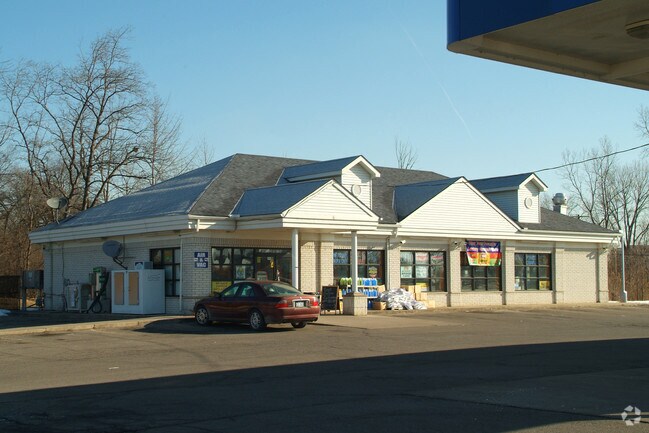
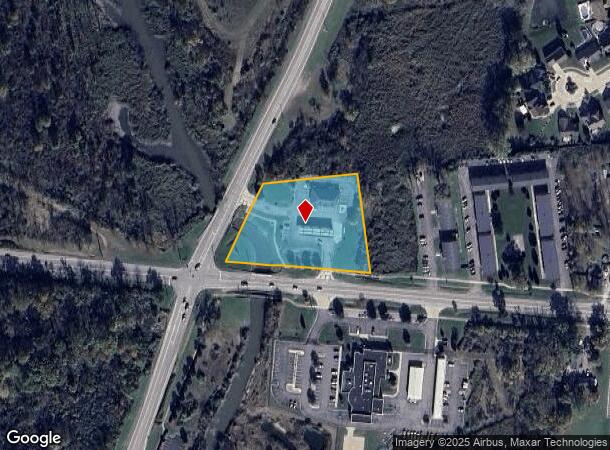
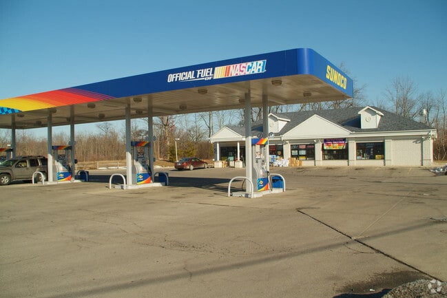
Property Record
28975 W Jefferson Ave, Gibraltar, MI 48173
NEARBY LISTINGS FOR SALE OR LEASE
Property Detail
28975 W Jefferson Ave
36-012-99-0020-000
01S T5S THAT PART OF PC 54 AND OF FRACL SEC 1 T5S R10E DESCRIBED AS BEGINNING AT THE INTERSECTION OF THE N LINE OF SEC 1 WITH THE E LINE OF RIVER RD 120 FT WIDE AND PROCEEDING TH N 85D 35M 35SEC E ALONG SAID SECTION LINE 270.17 FT TH S 5D 04M 25SEC E
Conveniencestore
Wayne
AE
Michigan
26163C0527F
0020
2023
2 AC
2025
Downriver South
597000
Detroit
3,200 SF
Detroit-Warren-Dearborn, MI
DEMOGRAPHICS near 28975 W Jefferson Ave
1 Mile
3 Mile
5 Mile
2024 Total Population
3,589
27,613
76,808
2029 Population
3,448
26,447
73,833
Pop Growth 2024-2029
(3.93%)
(4.22%)
(3.87%)
Average Age
43
43
43
2024 Total Households
1,534
11,326
31,625
HH Growth 2024-2029
(3.98%)
(4.26%)
(3.90%)
Median Household Inc
$84,847
$82,318
$81,022
Avg Household Size
2.30
2.40
2.40
2024 Avg HH Vehicles
2.00
2.00
2.00
Median Home Value
$227,764
$208,456
$220,764
Median Year Built
1973
1974
1974
Nearby Places
Map Layers
Map Styles
 Street
 Aerial
- Restaurants
- Banks
- Shops
- Fitness
- Groceries
PUBLIC TRANSPORTATION
AIRPORT
Detroit Metro Wayne County
DRIVE
WALK
Distance
Detroit Metro Wayne County
25 min
16.8 mi
Windsor International
DRIVE
WALK
Distance
Windsor International
50 min
32.3 mi
Freight Ports
Port of Toledo
DRIVE
WALK
Distance
Port of Toledo
53 min
40.9 mi
Nearby Properties
Address
Land Use
TOTAL SIZE
Lot Size
Zoning
Address
Land Use
TOTAL SIZE
Lot Size
Zoning
3,189,689 SF
228.88 AC
Address
Land Use
TOTAL SIZE
Lot Size
Zoning
215,724 SF
Address
Land Use
TOTAL SIZE
Lot Size
Zoning
2,651,867 SF
137.23 AC
I-3
Address
Land Use
TOTAL SIZE
Lot Size
Zoning
155,600 SF
83.84 AC
R1
Address
Land Use
TOTAL SIZE
Lot Size
Zoning
235,489 SF
23.47 AC
Address
Land Use
TOTAL SIZE
Lot Size
Zoning
150,224 SF
15.45 AC
RM-1
Address
Land Use
TOTAL SIZE
Lot Size
Zoning
1,021,918 SF
163.58 AC
Address
Land Use
TOTAL SIZE
Lot Size
Zoning
178,682 SF
19.23 AC
Address
Land Use
TOTAL SIZE
Lot Size
Zoning
33,600 SF
100.03 AC
Address
Land Use
TOTAL SIZE
Lot Size
Zoning
92,397 SF
12.63 AC
PUD
Address
Land Use
TOTAL SIZE
Lot Size
Zoning
169,192 SF
11.90 AC
R1
Address
Land Use
TOTAL SIZE
Lot Size
Zoning
59,427 SF
5.50 AC
Address
Land Use
TOTAL SIZE
Lot Size
Zoning
68,409 SF
64.56 AC
Address
Land Use
TOTAL SIZE
Lot Size
Zoning
2,368 SF
32.58 AC
Address
Land Use
TOTAL SIZE
Lot Size
Zoning
95,650 SF
73.78 AC
Address
Land Use
TOTAL SIZE
Lot Size
Zoning
48,760 SF
4.86 AC
Address
Land Use
TOTAL SIZE
Lot Size
Zoning
18,678 SF
3.10 AC
R1-ONE
Address
Land Use
TOTAL SIZE
Lot Size
Zoning
2,816 SF
86.70 AC
RESIDE
Address
Land Use
TOTAL SIZE
Lot Size
Zoning
146,300 SF
25.84 AC
Address
Land Use
TOTAL SIZE
Lot Size
Zoning
101,861 SF
15.33 AC
B-2
Address
Land Use
TOTAL SIZE
Lot Size
Zoning
62,039 SF
Address
Land Use
TOTAL SIZE
Lot Size
Zoning
164,567 SF
13.78 AC
RESIDE
Address
Land Use
TOTAL SIZE
Lot Size
Zoning
60 SF
3.83 AC
PCA
Address
Land Use
TOTAL SIZE
Lot Size
Zoning
551,184 SF
RESIDE
Address
Land Use
TOTAL SIZE
Lot Size
Zoning
124,602 SF
10.20 AC
Address
Land Use
TOTAL SIZE
Lot Size
Zoning
52,085 SF
5 AC
RM-1
Address
Land Use
TOTAL SIZE
Lot Size
Zoning
551,184 SF
42.34 AC
RESIDE
Address
Land Use
TOTAL SIZE
Lot Size
Zoning
16.38 AC
OR-1
Address
Land Use
TOTAL SIZE
Lot Size
Zoning
40,136 SF
42.97 AC
R-1-D
Address
Land Use
TOTAL SIZE
Lot Size
Zoning
7,222 SF
58.71 AC
The World's #1 Commercial Real Estate Marketplace
Connect with us
© 2025 CoStar Group
The information above has been obtained from sources believed reliable. While we do not doubt its accuracy we have not verified it and make no guarantee, warranty or representation about it. It is your responsibility to independently confirm its accuracy and completeness. Any projections, opinions, assumptions, or estimates used are for example only and do not represent the current or future performance of the property. The value of this transaction to you depends on tax and other factors which should be evaluated by your tax, financial, and legal advisors. You and your advisors should conduct a careful, independent investigation of the property to determine to your satisfaction the suitability of the property for your needs.