Property Record
2898 W West Point Rd, Lagrange, GA 30240

NEARBY LISTINGS FOR SALE OR LEASE
-
-
View all Lagrange listings for sale on LoopNet.com
Property Detail
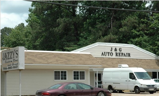
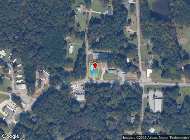
2898 W West Point Rd
071-3B-000-003
2898 WEST POINT RD/LL 89 LOT TR-1
Autorepair
Troup
X
Georgia
13285C0140F
0.33 AC
2024
Troup County
2025
Columbus GA
960903
LaGrange, GA-AL
4,088 SF
DEMOGRAPHICS near 2898 W West Point Rd
1 mile
3 mile
5 mile
2024 Total Population
1,251
9,900
26,638
2029 Population
1,258
9,951
27,011
Pop Growth 2024-2029
+ 0.56%
+ 0.52%
+ 1.40%
Average Age
41
41
39
2024 Total Households
492
3,811
10,389
HH Growth 2024-2029
+ 0.61%
+ 0.55%
+ 1.42%
Median Household Inc
$71,911
$60,036
$47,419
Avg Household Size
2.50
2.50
2.50
2024 Avg HH Vehicles
2.00
2.00
2.00
Median Home Value
$229,577
$198,720
$180,576
Median Year Built
1992
1987
1979
Nearby Places
Map Layers
Map Styles
 Street
 Aerial
Transit
 Traffic
 Biking
Places
Listings with unknown addresses are not visible on the map
- Restaurants
- Banks
- Shops
- Fitness
- Groceries
SALE & LEASE HISTORY
LISTING DATE
SALE/LEASE

Aug 26, 2019
For Sale
Nearby Properties
Address
Land Use
TOTAL SIZE
Lot Size
Zoning
Address
Land Use
TOTAL SIZE
Lot Size
Zoning
35,964 SF
72.39 AC
16- CP-GI
Address
Land Use
TOTAL SIZE
Lot Size
Zoning
525,250 SF
45.33 AC
16- CP-GI
Address
Land Use
TOTAL SIZE
Lot Size
Zoning
17,328 SF
10.66 AC
16- CP-GB
Address
Land Use
TOTAL SIZE
Lot Size
Zoning
35,269 SF
22.34 AC
16- CR-MR
Address
Land Use
TOTAL SIZE
Lot Size
Zoning
95,472 SF
30.05 AC
16- CR-MR
Address
Land Use
TOTAL SIZE
Lot Size
Zoning
4,909 SF
731.14 AC
16- CP-GI
Address
Land Use
TOTAL SIZE
Lot Size
Zoning
323,137 SF
34.65 AC
16- CP-GI
Address
Land Use
TOTAL SIZE
Lot Size
Zoning
30,224 SF
19.82 AC
16- CP-GI
Address
Land Use
TOTAL SIZE
Lot Size
Zoning
26,595 SF
20.13 AC
16- CR-MX
Address
Land Use
TOTAL SIZE
Lot Size
Zoning
151,088 SF
7.10 AC
16- CP-GI
Address
Land Use
TOTAL SIZE
Lot Size
Zoning
89,395 SF
28.47 AC
16- TN-R
Address
Land Use
TOTAL SIZE
Lot Size
Zoning
56,580 SF
12.87 AC
16- CR-MX
Address
Land Use
TOTAL SIZE
Lot Size
Zoning
97,903 SF
4.50 AC
16- CP-GI
Address
Land Use
TOTAL SIZE
Lot Size
Zoning
1 AC
16-UNAVAIL
Address
Land Use
TOTAL SIZE
Lot Size
Zoning
2,513 SF
14.10 AC
16- TN-MX
Address
Land Use
TOTAL SIZE
Lot Size
Zoning
80,979 SF
15 AC
16- CP-GI
Address
Land Use
TOTAL SIZE
Lot Size
Zoning
260,400 SF
7.52 AC
16- CP-GI
Address
Land Use
TOTAL SIZE
Lot Size
Zoning
79,956 SF
16.23 AC
16- CP-GI
Address
Land Use
TOTAL SIZE
Lot Size
Zoning
28,390 SF
9.40 AC
16- CP-GB
Address
Land Use
TOTAL SIZE
Lot Size
Zoning
3,188 SF
12.22 AC
16- CP-GB
Address
Land Use
TOTAL SIZE
Lot Size
Zoning
65,624 SF
10.39 AC
16- CP-GI
Address
Land Use
TOTAL SIZE
Lot Size
Zoning
71,626 SF
10.81 AC
16- CR-MX
Address
Land Use
TOTAL SIZE
Lot Size
Zoning
17,780 SF
14.43 AC
16- CP-GI
Address
Land Use
TOTAL SIZE
Lot Size
Zoning
54,103 SF
15.17 AC
16- CP-GI
Address
Land Use
TOTAL SIZE
Lot Size
Zoning
1 AC
16-UNAVAIL
Address
Land Use
TOTAL SIZE
Lot Size
Zoning
14,810 SF
3.70 AC
16- CR-MX
Address
Land Use
TOTAL SIZE
Lot Size
Zoning
1,279.17 AC
16- CP-GI
Address
Land Use
TOTAL SIZE
Lot Size
Zoning
3.99 AC
16- CP-GB
Address
Land Use
TOTAL SIZE
Lot Size
Zoning
507.64 AC
UNKNOWN
Address
Land Use
TOTAL SIZE
Lot Size
Zoning
1 AC
16-UNAVAIL
The World's #1 Commercial Real Estate Marketplace
Connect with us
© 2026 CoStar Group
The information above has been obtained from sources believed reliable. While we do not doubt its accuracy we have not verified it and make no guarantee, warranty or representation about it. It is your responsibility to independently confirm its accuracy and completeness. Any projections, opinions, assumptions, or estimates used are for example only and do not represent the current or future performance of the property. The value of this transaction to you depends on tax and other factors which should be evaluated by your tax, financial, and legal advisors. You and your advisors should conduct a careful, independent investigation of the property to determine to your satisfaction the suitability of the property for your needs.