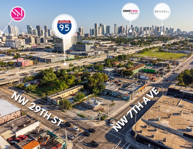
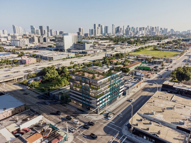
Property Record
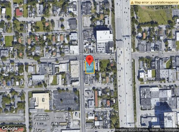
2899 Nw 7Th Ave, Miami, FL 33127
NEARBY LISTINGS FOR SALE OR LEASE
Property Detail
2899 Nw 7Th Ave
Miami-Miami Beach-Kendall, FL
Northern Blvd
01-3125-024-2450
NORTHERN BLVD TR PB 2-29 LOTS 11 & 12 LESS W7.5FT BLK 15 & LESS BEG 45FTS & 40FTE OF NW 29 ST & NW 7 AVE PER FOT MAINT MAP PB 152-9 TH N 87 DEG E 6FT S 02 DEG E 11FT S 87 DEG W 6FT N O2 DEG W 11FT TO POB BLK 15 LOT SIZE 15404 SQ FT M/L
Restaurantbuilding
Miami/Dade
X
Florida
12086C0312L
11,12
2024
0.35 AC
2025
Miami
002502
South Florida
1,194 SF
DEMOGRAPHICS near 2899 Nw 7Th Ave
1 Mile
3 Mile
5 Mile
2024 Total Population
30,955
310,940
592,178
2029 Population
31,036
308,973
585,474
Pop Growth 2024-2029
+ 0.26%
(0.63%)
(1.13%)
Average Age
38
39
41
2024 Total Households
11,679
131,316
247,313
HH Growth 2024-2029
+ 0.77%
(0.63%)
(1.08%)
Median Household Inc
$42,660
$46,412
$51,439
Avg Household Size
2.40
2.20
2.30
2024 Avg HH Vehicles
1.00
1.00
1.00
Median Home Value
$364,852
$391,259
$406,731
Median Year Built
1979
1988
1975
Nearby Places
- Restaurants
- Banks
- Shops
- Fitness
- Groceries
PUBLIC TRANSPORTATION
TRANSIT/SUBWAY
Allapattah (Metrorail Green Line - Miami-Dade Transit (Metrorail/Metromover))
DRIVE
WALK
Distance
Allapattah (Metrorail Green Line - Miami-Dade Transit (Metrorail/Metromover))
2 min
18 min
0.9 mi
COMMUTER RAIL
Allapattah (Metrorail Green Line - Miami-Dade Transit (Metrorail/Metromover))
DRIVE
WALK
Distance
Allapattah (Metrorail Green Line - Miami-Dade Transit (Metrorail/Metromover))
2 min
18 min
0.9 mi
Santa Clara (Metrorail Green Line - Miami-Dade Transit (Metrorail/Metromover))
DRIVE
WALK
Distance
Santa Clara (Metrorail Green Line - Miami-Dade Transit (Metrorail/Metromover))
3 min
1.0 mi
AIRPORT
Miami International
DRIVE
WALK
Distance
Miami International
21 min
9.1 mi
Fort Lauderdale/Hollywood International
DRIVE
WALK
Distance
Fort Lauderdale/Hollywood International
32 min
21.1 mi
Freight Ports
Port of Miami
DRIVE
WALK
Distance
Port of Miami
11 min
4.4 mi
SALE & LEASE HISTORY
LISTING DATE
SALE/LEASE

Oct 07, 2020
For Lease
Mar 31, 2020
For Sale
Jan 09, 2023
For Sale
Aug 12, 2022
For Lease
Apr 01, 2021
For Lease
Nearby Properties
Address
Land Use
TOTAL SIZE
Lot Size
Zoning
Address
Land Use
TOTAL SIZE
Lot Size
Zoning
1,050,691 SF
0.83 AC
6408
Address
Land Use
TOTAL SIZE
Lot Size
Zoning
4,758,614 SF
810.91 AC
8000
Address
Land Use
TOTAL SIZE
Lot Size
Zoning
955,966 SF
38.91 AC
9600
Address
Land Use
TOTAL SIZE
Lot Size
Zoning
2,559,318 SF
2.21 AC
6407
Address
Land Use
TOTAL SIZE
Lot Size
Zoning
2,039,308 SF
2.46 AC
6401
Address
Land Use
TOTAL SIZE
Lot Size
Zoning
928,000 SF
14.30 AC
8000
Address
Land Use
TOTAL SIZE
Lot Size
Zoning
1,110,657 SF
3.83 AC
6407
Address
Land Use
TOTAL SIZE
Lot Size
Zoning
16.13 AC
6100
Address
Land Use
TOTAL SIZE
Lot Size
Zoning
1,346,294 SF
1.89 AC
6408
Address
Land Use
TOTAL SIZE
Lot Size
Zoning
2,403,353 SF
7.37 AC
6100
Address
Land Use
TOTAL SIZE
Lot Size
Zoning
1,938,271 SF
6.62 AC
6402
Address
Land Use
TOTAL SIZE
Lot Size
Zoning
1,075,124 SF
1.61 AC
6405
Address
Land Use
TOTAL SIZE
Lot Size
Zoning
1,544,491 SF
0.97 AC
6401
Address
Land Use
TOTAL SIZE
Lot Size
Zoning
782,686 SF
0.06 AC
6401
Address
Land Use
TOTAL SIZE
Lot Size
Zoning
1,657,362 SF
1.15 AC
6401
Address
Land Use
TOTAL SIZE
Lot Size
Zoning
244,533 SF
3.53 AC
6600
Address
Land Use
TOTAL SIZE
Lot Size
Zoning
694,863 SF
1.90 AC
6407
Address
Land Use
TOTAL SIZE
Lot Size
Zoning
303,989 SF
1.47 AC
6600
Address
Land Use
TOTAL SIZE
Lot Size
Zoning
416,675 SF
6.48 AC
6401
Address
Land Use
TOTAL SIZE
Lot Size
Zoning
256,089 SF
20.35 AC
7600
Address
Land Use
TOTAL SIZE
Lot Size
Zoning
1,004,006 SF
0.92 AC
6401
Address
Land Use
TOTAL SIZE
Lot Size
Zoning
585,775 SF
1.86 AC
6101
Address
Land Use
TOTAL SIZE
Lot Size
Zoning
868,860 SF
2.14 AC
6402
Address
Land Use
TOTAL SIZE
Lot Size
Zoning
491,308 SF
0.14 AC
6401
Address
Land Use
TOTAL SIZE
Lot Size
Zoning
903,993 SF
0.60 AC
6412
Address
Land Use
TOTAL SIZE
Lot Size
Zoning
872,245 SF
0.56 AC
6401
Address
Land Use
TOTAL SIZE
Lot Size
Zoning
615,785 SF
3.81 AC
4604
Address
Land Use
TOTAL SIZE
Lot Size
Zoning
727,757 SF
0.64 AC
6408
Address
Land Use
TOTAL SIZE
Lot Size
Zoning
2 AC
8000
Address
Land Use
TOTAL SIZE
Lot Size
Zoning
1,262,330 SF
1.39 AC
6402
The World's #1 Commercial Real Estate Marketplace
Connect with us
© 2025 CoStar Group
The information above has been obtained from sources believed reliable. While we do not doubt its accuracy we have not verified it and make no guarantee, warranty or representation about it. It is your responsibility to independently confirm its accuracy and completeness. Any projections, opinions, assumptions, or estimates used are for example only and do not represent the current or future performance of the property. The value of this transaction to you depends on tax and other factors which should be evaluated by your tax, financial, and legal advisors. You and your advisors should conduct a careful, independent investigation of the property to determine to your satisfaction the suitability of the property for your needs.