Property Record
28993 Interstate 10 W, Boerne, TX 78006
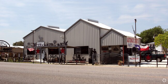

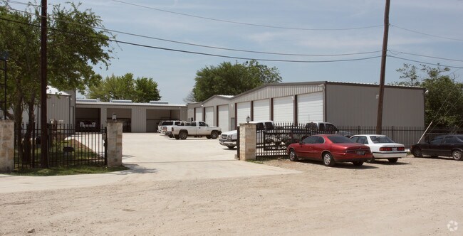
Property Detail
28993 Interstate 10 W
San Antonio-New Braunfels, TX
CB 4707C BLK 13 LOT 14 SERIAL #GAMFXMS03206 2018-MERGED ACCT PER CR #42955. LR/GIS/10-11-17.
04707-313-0143
BEXAR
Officebuilding
Texas
B and X Area of moderate flood hazard, usually the area between the limits of the 100-year and 500-year floods.
143
2025
0.89 AC
2025
Far Northwest
182102
San Antonio
14,582 SF
NEARBY LISTINGS FOR SALE OR LEASE
DEMOGRAPHICS near 28993 Interstate 10 W
1 mile
3 mile
5 mile
2025 Total Population
3,849
26,607
57,335
2030 Population
4,121
28,961
62,640
Pop Growth 2025-2030
+ 7.07%
+ 8.85%
+ 9.25%
Average Age
41
40
40
2025 Total Households
1,363
9,287
19,824
HH Growth 2025-2030
+ 7.26%
+ 9.11%
+ 9.49%
Median Household Inc
$135,156
$142,654
$138,132
Avg Household Size
2.80
2.80
2.90
2025 Avg HH Vehicles
2.00
2.00
2.00
Median Home Value
$613,574
$516,329
$507,755
Median Year Built
2007
2010
2010
Nearby Places
Map Layers
Map Styles
 Street
 Aerial
Layers
 Traffic
 Biking
Places
Listings with unknown addresses are not visible on the map
- Restaurants
- Banks
- Shops
- Fitness
- Groceries
PUBLIC TRANSPORTATION
AIRPORT
San Antonio International
Drive
Walk
Distance
San Antonio International
28 min
23.0 mi
Nearby Properties
Address
Land Use
TOTAL SIZE
Lot Size
Zoning
Address
Land Use
TOTAL SIZE
Lot Size
Zoning
252,468 SF
56.42 AC
Address
Land Use
TOTAL SIZE
Lot Size
Zoning
260,536 SF
10.71 AC
Address
Land Use
TOTAL SIZE
Lot Size
Zoning
282,991 SF
26.41 AC
Address
Land Use
TOTAL SIZE
Lot Size
Zoning
265,093 SF
12.55 AC
Address
Land Use
TOTAL SIZE
Lot Size
Zoning
255,907 SF
19.93 AC
Address
Land Use
TOTAL SIZE
Lot Size
Zoning
215,736 SF
10.06 AC
Address
Land Use
TOTAL SIZE
Lot Size
Zoning
126,885 SF
16 AC
Address
Land Use
TOTAL SIZE
Lot Size
Zoning
49,164 SF
11.98 AC
Address
Land Use
TOTAL SIZE
Lot Size
Zoning
46,562 SF
3.02 AC
Address
Land Use
TOTAL SIZE
Lot Size
Zoning
247,144 SF
17.49 AC
Address
Land Use
TOTAL SIZE
Lot Size
Zoning
145,171 SF
13.65 AC
Address
Land Use
TOTAL SIZE
Lot Size
Zoning
91,013 SF
6.45 AC
Address
Land Use
TOTAL SIZE
Lot Size
Zoning
43,422 SF
6.38 AC
Address
Land Use
TOTAL SIZE
Lot Size
Zoning
297,618 SF
13.20 AC
Address
Land Use
TOTAL SIZE
Lot Size
Zoning
36,632 SF
142.92 AC
Address
Land Use
TOTAL SIZE
Lot Size
Zoning
42,101 SF
6.03 AC
Address
Land Use
TOTAL SIZE
Lot Size
Zoning
60,750 SF
15.53 AC
Address
Land Use
TOTAL SIZE
Lot Size
Zoning
175.13 AC
Address
Land Use
TOTAL SIZE
Lot Size
Zoning
103,963 SF
1.98 AC
Address
Land Use
TOTAL SIZE
Lot Size
Zoning
48,139 SF
10.38 AC
Address
Land Use
TOTAL SIZE
Lot Size
Zoning
46,649 SF
17.82 AC
Address
Land Use
TOTAL SIZE
Lot Size
Zoning
10,078 SF
15.47 AC
Address
Land Use
TOTAL SIZE
Lot Size
Zoning
42,442 SF
119.10 AC
Address
Land Use
TOTAL SIZE
Lot Size
Zoning
7,537 SF
111.13 AC
Address
Land Use
TOTAL SIZE
Lot Size
Zoning
107,081 SF
7.41 AC
Address
Land Use
TOTAL SIZE
Lot Size
Zoning
47,942 SF
19.90 AC
Address
Land Use
TOTAL SIZE
Lot Size
Zoning
53,204 SF
3.23 AC
Address
Land Use
TOTAL SIZE
Lot Size
Zoning
16,110 SF
1.78 AC
Address
Land Use
TOTAL SIZE
Lot Size
Zoning
29,175 SF
12.50 AC
Address
Land Use
TOTAL SIZE
Lot Size
Zoning
30,900 SF
3.20 AC
The World's #1 Commercial Real Estate Marketplace
Connect with us
© 2026 CoStar Group
The information above has been obtained from sources believed reliable. While we do not doubt its accuracy we have not verified it and make no guarantee, warranty or representation about it. It is your responsibility to independently confirm its accuracy and completeness. Any projections, opinions, assumptions, or estimates used are for example only and do not represent the current or future performance of the property. The value of this transaction to you depends on tax and other factors which should be evaluated by your tax, financial, and legal advisors. You and your advisors should conduct a careful, independent investigation of the property to determine to your satisfaction the suitability of the property for your needs.