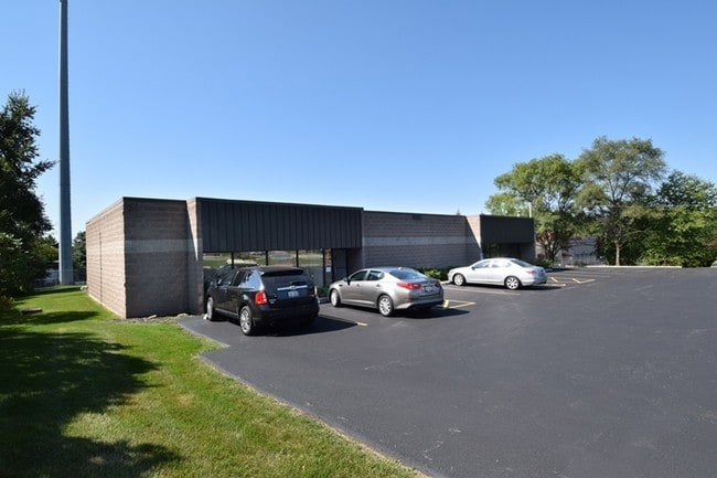
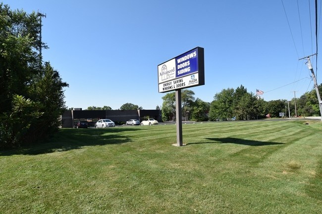
Property Record
28W671 Garys Mill Rd, Winfield, IL 60190

Save to a Folder
{{folder.Name}}
{{folder.ListingIds.length}} Properties
{{folder.ListingIds.length}} Property
Create a New Folder
Property Detail
28W671 Garys Mill Rd
04-14-305-015
LARSON WEBER AP /EX DEMOS AP/ SW 1/4 SW 1/4 DESC IN BK 64 OF DDS PG 393 N 41.17 FT LYG S OF W150 FT OF LARSON WEBER AP
Commercialnec
DuPage
C
Illinois
B and X Area of moderate flood hazard, usually the area between the limits of the 100-year and 500-year floods.
1
2024
1 AC
2024
Western East/West Corr
841603
Chicago
4,000 SF
Chicago-Naperville-Elgin, IL-IN
NEARBY LISTINGS FOR SALE OR LEASE
DEMOGRAPHICS near 28W671 Garys Mill Rd
1 mile
3 mile
5 mile
2025 Total Population
3,529
51,726
141,105
2030 Population
3,547
51,793
142,194
Pop Growth 2025-2030
+ 0.51%
+ 0.13%
+ 0.77%
Average Age
37
41
41
2025 Total Households
1,136
17,923
50,570
HH Growth 2025-2030
+ 0.53%
+ 0.12%
+ 0.89%
Median Household Inc
$79,241
$103,166
$112,455
Avg Household Size
3.00
2.70
2.60
2025 Avg HH Vehicles
2.00
2.00
2.00
Median Home Value
$316,522
$319,577
$384,226
Median Year Built
1977
1975
1979
Nearby Places
Map Layers
Map Styles
 Street
 Aerial
Layers
 Traffic
 Biking
Places
Listings with unknown addresses are not visible on the map
- Restaurants
- Banks
- Shops
- Fitness
- Groceries
PUBLIC TRANSPORTATION
COMMUTER RAIL
Winfield Station (Union Pacific West Line - Northeast Illinois Regional Commuter Railroad (Metra))
Drive
Walk
Distance
Winfield Station (Union Pacific West Line - Northeast Illinois Regional Commuter Railroad (Metra))
4 min
2.1 mi
West Chicago Station (Union Pacific West Line - Northeast Illinois Regional Commuter Railroad (Metra))
Drive
Walk
Distance
West Chicago Station (Union Pacific West Line - Northeast Illinois Regional Commuter Railroad (Metra))
5 min
2.3 mi
AIRPORT
Chicago Midway International
Drive
Walk
Distance
Chicago Midway International
45 min
26.5 mi
Chicago O'Hare International
Drive
Walk
Distance
Chicago O'Hare International
44 min
26.6 mi
Freight Ports
Port Milwaukee
Drive
Walk
Distance
Port Milwaukee
124 min
99.0 mi
Nearby Properties
Address
Land Use
TOTAL SIZE
Lot Size
Zoning
Address
Land Use
TOTAL SIZE
Lot Size
Zoning
545,570 SF
22.66 AC
C
Address
Land Use
TOTAL SIZE
Lot Size
Zoning
26,302 SF
2.09 AC
C
Address
Land Use
TOTAL SIZE
Lot Size
Zoning
Address
Land Use
TOTAL SIZE
Lot Size
Zoning
28.84 AC
Address
Land Use
TOTAL SIZE
Lot Size
Zoning
277,018 SF
12.36 AC
I
Address
Land Use
TOTAL SIZE
Lot Size
Zoning
165,528 SF
16.08 AC
M
Address
Land Use
TOTAL SIZE
Lot Size
Zoning
242,748 SF
11.65 AC
R
Address
Land Use
TOTAL SIZE
Lot Size
Zoning
13.15 AC
R
Address
Land Use
TOTAL SIZE
Lot Size
Zoning
409,705 SF
16.21 AC
I
Address
Land Use
TOTAL SIZE
Lot Size
Zoning
1,808 SF
0.19 AC
C
Address
Land Use
TOTAL SIZE
Lot Size
Zoning
137,196 SF
8.82 AC
R
Address
Land Use
TOTAL SIZE
Lot Size
Zoning
65,113 SF
2.77 AC
C
Address
Land Use
TOTAL SIZE
Lot Size
Zoning
181,420 SF
6.69 AC
I
Address
Land Use
TOTAL SIZE
Lot Size
Zoning
6.55 AC
C
Address
Land Use
TOTAL SIZE
Lot Size
Zoning
108,825 SF
23.42 AC
C
Address
Land Use
TOTAL SIZE
Lot Size
Zoning
64,384 SF
6.97 AC
C
Address
Land Use
TOTAL SIZE
Lot Size
Zoning
97,122 SF
4.42 AC
I
Address
Land Use
TOTAL SIZE
Lot Size
Zoning
41,529 SF
7.73 AC
C
Address
Land Use
TOTAL SIZE
Lot Size
Zoning
136,036 SF
12.31 AC
C
Address
Land Use
TOTAL SIZE
Lot Size
Zoning
38,749 SF
6.75 AC
C
Address
Land Use
TOTAL SIZE
Lot Size
Zoning
3.70 AC
Address
Land Use
TOTAL SIZE
Lot Size
Zoning
39,362 SF
4.70 AC
C
Address
Land Use
TOTAL SIZE
Lot Size
Zoning
2.29 AC
Address
Land Use
TOTAL SIZE
Lot Size
Zoning
56,475 SF
4.02 AC
I
Address
Land Use
TOTAL SIZE
Lot Size
Zoning
3.32 AC
Address
Land Use
TOTAL SIZE
Lot Size
Zoning
53,182 SF
6.29 AC
I
Address
Land Use
TOTAL SIZE
Lot Size
Zoning
56,067 SF
5.07 AC
I
Address
Land Use
TOTAL SIZE
Lot Size
Zoning
88,531 SF
5.88 AC
C
Address
Land Use
TOTAL SIZE
Lot Size
Zoning
65,945 SF
1.34 AC
I
Address
Land Use
TOTAL SIZE
Lot Size
Zoning
2,048 SF
3.72 AC
C
The World's #1 Commercial Real Estate Marketplace
Connect with us
© 2026 CoStar Group
The information above has been obtained from sources believed reliable. While we do not doubt its accuracy we have not verified it and make no guarantee, warranty or representation about it. It is your responsibility to independently confirm its accuracy and completeness. Any projections, opinions, assumptions, or estimates used are for example only and do not represent the current or future performance of the property. The value of this transaction to you depends on tax and other factors which should be evaluated by your tax, financial, and legal advisors. You and your advisors should conduct a careful, independent investigation of the property to determine to your satisfaction the suitability of the property for your needs.