Property Record
29 2Nd Ave S, Birmingham, AL 35205
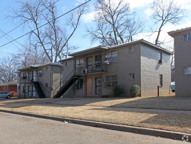


Property Detail
29 2Nd Ave S
29-00-03-4-016-002.000
LOTS 2 THRU 5 BLK 4 SESSIONS LD CO SUB OF BLKS 3+4 WALKER LAND CO
Apartment
Jefferson
R5
Alabama
AH Areas with a 1% annual chance of shallow flooding, usually in the form of a pond, withan average depth ranging from 1 to 3 feet. These areas have a 26% chance of flooding over the life of a 30-year mortgage.
2-5
2024
0.69 AC
2025
Titusville
005101
Birmingham
8,960 SF
Birmingham, AL
NEARBY LISTINGS FOR SALE OR LEASE
DEMOGRAPHICS near 29 2Nd Ave S
1 mile
3 mile
5 mile
2025 Total Population
9,618
89,470
181,384
2030 Population
10,031
90,950
182,456
Pop Growth 2025-2030
+ 4.29%
+ 1.65%
+ 0.59%
Average Age
43
38
39
2025 Total Households
4,367
40,323
78,719
HH Growth 2025-2030
+ 4.49%
+ 1.72%
+ 0.55%
Median Household Inc
$33,381
$44,760
$49,471
Avg Household Size
2.00
2.00
2.10
2025 Avg HH Vehicles
1.00
1.00
2.00
Median Home Value
$114,158
$195,381
$217,291
Median Year Built
1962
1965
1965
Nearby Places
Map Layers
Map Styles
 Street
 Aerial
Layers
 Traffic
 Biking
Places
Listings with unknown addresses are not visible on the map
- Restaurants
- Banks
- Shops
- Fitness
- Groceries
PUBLIC TRANSPORTATION
COMMUTER RAIL
Birmingham (Crescent - Amtrak)
Drive
Walk
Distance
Birmingham (Crescent - Amtrak)
5 min
2.4 mi
AIRPORT
Birmingham-Shuttlesworth International
Drive
Walk
Distance
Birmingham-Shuttlesworth International
13 min
7.5 mi
Freight Ports
Port of Mobile
Drive
Walk
Distance
Port of Mobile
279 min
254.3 mi
Nearby Properties
Address
Land Use
TOTAL SIZE
Lot Size
Zoning
Address
Land Use
TOTAL SIZE
Lot Size
Zoning
296,284 SF
12 AC
OI
Address
Land Use
TOTAL SIZE
Lot Size
Zoning
305,826 SF
4 AC
B4
Address
Land Use
TOTAL SIZE
Lot Size
Zoning
189,447 SF
4 AC
B4
Address
Land Use
TOTAL SIZE
Lot Size
Zoning
224,049 SF
4 AC
M1
Address
Land Use
TOTAL SIZE
Lot Size
Zoning
239,334 SF
4 AC
B6
Address
Land Use
TOTAL SIZE
Lot Size
Zoning
203,878 SF
13 AC
B6
Address
Land Use
TOTAL SIZE
Lot Size
Zoning
183,862 SF
10 AC
B4
Address
Land Use
TOTAL SIZE
Lot Size
Zoning
230,441 SF
10 AC
M1
Address
Land Use
TOTAL SIZE
Lot Size
Zoning
106,144 SF
1 AC
B4
Address
Land Use
TOTAL SIZE
Lot Size
Zoning
94,958 SF
4 AC
M1
Address
Land Use
TOTAL SIZE
Lot Size
Zoning
334,463 SF
2 AC
B4
Address
Land Use
TOTAL SIZE
Lot Size
Zoning
57,066 SF
1 AC
B4
Address
Land Use
TOTAL SIZE
Lot Size
Zoning
46,161 SF
1 AC
M1-B
Address
Land Use
TOTAL SIZE
Lot Size
Zoning
95,993 SF
3.67 AC
M1
Address
Land Use
TOTAL SIZE
Lot Size
Zoning
229,669 SF
2.75 AC
B4
Address
Land Use
TOTAL SIZE
Lot Size
Zoning
109,411 SF
3 AC
B4
Address
Land Use
TOTAL SIZE
Lot Size
Zoning
344,150 SF
42 AC
R5
Address
Land Use
TOTAL SIZE
Lot Size
Zoning
2 AC
M1-B
Address
Land Use
TOTAL SIZE
Lot Size
Zoning
1,666 SF
2 AC
M1
Address
Land Use
TOTAL SIZE
Lot Size
Zoning
30,453 SF
0.87 AC
B2
Address
Land Use
TOTAL SIZE
Lot Size
Zoning
2 AC
B4
Address
Land Use
TOTAL SIZE
Lot Size
Zoning
29,136 SF
2 AC
B4
Address
Land Use
TOTAL SIZE
Lot Size
Zoning
79,458 SF
1 AC
B4
Address
Land Use
TOTAL SIZE
Lot Size
Zoning
143,200 SF
23.49 AC
R3/O
Address
Land Use
TOTAL SIZE
Lot Size
Zoning
416,477 SF
80 AC
R5
Address
Land Use
TOTAL SIZE
Lot Size
Zoning
109,819 SF
2.91 AC
M2
Address
Land Use
TOTAL SIZE
Lot Size
Zoning
62,350 SF
1.29 AC
B-4
Address
Land Use
TOTAL SIZE
Lot Size
Zoning
156,986 SF
1.29 AC
M1
Address
Land Use
TOTAL SIZE
Lot Size
Zoning
96,102 SF
1.74 AC
B4
Address
Land Use
TOTAL SIZE
Lot Size
Zoning
2 AC
B4
The World's #1 Commercial Real Estate Marketplace
Connect with us
© 2026 CoStar Group
The information above has been obtained from sources believed reliable. While we do not doubt its accuracy we have not verified it and make no guarantee, warranty or representation about it. It is your responsibility to independently confirm its accuracy and completeness. Any projections, opinions, assumptions, or estimates used are for example only and do not represent the current or future performance of the property. The value of this transaction to you depends on tax and other factors which should be evaluated by your tax, financial, and legal advisors. You and your advisors should conduct a careful, independent investigation of the property to determine to your satisfaction the suitability of the property for your needs.