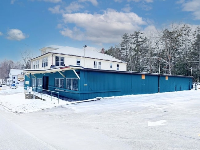
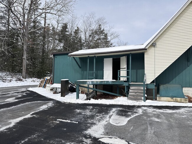
Property Record
29 Brookfield Rd, Fiskdale, MA 01518

NEARBY LISTINGS FOR SALE OR LEASE
-
-
View all Fiskdale listings for lease on LoopNet.com
Property Detail
29 Brookfield Rd
STUR-000173-000000-002327-000029
Worcester
Commercialofficeresidentialmixeduse
Massachusetts
X
2327-29
09015C0025F
0.45 AC
2025
Outlying Worcester
2025
Boston
758103
Worcester, MA-CT
7,995 SF
DEMOGRAPHICS near 29 Brookfield Rd
1 Mile
3 Mile
5 Mile
2024 Total Population
2,099
7,421
22,195
2029 Population
2,092
7,437
22,120
Pop Growth 2024-2029
(0.33%)
+ 0.22%
(0.34%)
Average Age
39
42
42
2024 Total Households
832
2,930
8,877
HH Growth 2024-2029
(0.36%)
+ 0.17%
(0.37%)
Median Household Inc
$77,459
$101,683
$84,448
Avg Household Size
2.50
2.50
2.50
2024 Avg HH Vehicles
2.00
2.00
2.00
Median Home Value
$341,558
$368,013
$341,482
Median Year Built
1979
1981
1974
Nearby Places
Map Layers
Map Styles
 Street
 Aerial
- Restaurants
- Banks
- Shops
- Fitness
- Groceries
PUBLIC TRANSPORTATION
AIRPORT
Worcester Regional
DRIVE
WALK
Distance
Worcester Regional
38 min
23.5 mi
Freight Ports
Port of Davisville, RI
DRIVE
WALK
Distance
Port of Davisville, RI
95 min
74.8 mi
SALE & LEASE HISTORY
LISTING DATE
SALE/LEASE

Nov 28, 2018
For Sale
May 10, 2022
For Lease
May 10, 2022
For Sale
Feb 26, 2025
For Lease
Aug 20, 2019
For Lease
Nearby Properties
Address
Land Use
TOTAL SIZE
Lot Size
Zoning
Address
Land Use
TOTAL SIZE
Lot Size
Zoning
127,762 SF
19.28 AC
Address
Land Use
TOTAL SIZE
Lot Size
Zoning
Address
Land Use
TOTAL SIZE
Lot Size
Zoning
208,444 SF
14.09 AC
Address
Land Use
TOTAL SIZE
Lot Size
Zoning
40,910 SF
25.36 AC
Address
Land Use
TOTAL SIZE
Lot Size
Zoning
Address
Land Use
TOTAL SIZE
Lot Size
Zoning
4,704 SF
76 AC
Address
Land Use
TOTAL SIZE
Lot Size
Zoning
189.22 AC
B
Address
Land Use
TOTAL SIZE
Lot Size
Zoning
105,660 SF
Address
Land Use
TOTAL SIZE
Lot Size
Zoning
15,000 SF
2 AC
Address
Land Use
TOTAL SIZE
Lot Size
Zoning
43,817 SF
3.17 AC
Address
Land Use
TOTAL SIZE
Lot Size
Zoning
55,530 SF
4.74 AC
Address
Land Use
TOTAL SIZE
Lot Size
Zoning
68,898 SF
49.02 AC
Address
Land Use
TOTAL SIZE
Lot Size
Zoning
52,255 SF
Address
Land Use
TOTAL SIZE
Lot Size
Zoning
36,220 SF
1.42 AC
Address
Land Use
TOTAL SIZE
Lot Size
Zoning
65,104 SF
9.60 AC
Address
Land Use
TOTAL SIZE
Lot Size
Zoning
4,888 SF
12.33 AC
Address
Land Use
TOTAL SIZE
Lot Size
Zoning
51,006 SF
10.54 AC
Address
Land Use
TOTAL SIZE
Lot Size
Zoning
73,136 SF
7.70 AC
Address
Land Use
TOTAL SIZE
Lot Size
Zoning
35,281 SF
2.68 AC
Address
Land Use
TOTAL SIZE
Lot Size
Zoning
28,371 SF
1.85 AC
Address
Land Use
TOTAL SIZE
Lot Size
Zoning
180,013 SF
6.84 AC
Address
Land Use
TOTAL SIZE
Lot Size
Zoning
39,576 SF
3.48 AC
Address
Land Use
TOTAL SIZE
Lot Size
Zoning
2,752 SF
0.22 AC
Address
Land Use
TOTAL SIZE
Lot Size
Zoning
10,678 SF
4.33 AC
Address
Land Use
TOTAL SIZE
Lot Size
Zoning
14,671 SF
1 AC
Address
Land Use
TOTAL SIZE
Lot Size
Zoning
10,148 SF
4.37 AC
Address
Land Use
TOTAL SIZE
Lot Size
Zoning
54,599 SF
5.37 AC
Address
Land Use
TOTAL SIZE
Lot Size
Zoning
45,886 SF
2.08 AC
Address
Land Use
TOTAL SIZE
Lot Size
Zoning
25,783 SF
42.49 AC
Address
Land Use
TOTAL SIZE
Lot Size
Zoning
65.96 AC
AR
The World's #1 Commercial Real Estate Marketplace
Connect with us
© 2025 CoStar Group
The information above has been obtained from sources believed reliable. While we do not doubt its accuracy we have not verified it and make no guarantee, warranty or representation about it. It is your responsibility to independently confirm its accuracy and completeness. Any projections, opinions, assumptions, or estimates used are for example only and do not represent the current or future performance of the property. The value of this transaction to you depends on tax and other factors which should be evaluated by your tax, financial, and legal advisors. You and your advisors should conduct a careful, independent investigation of the property to determine to your satisfaction the suitability of the property for your needs.