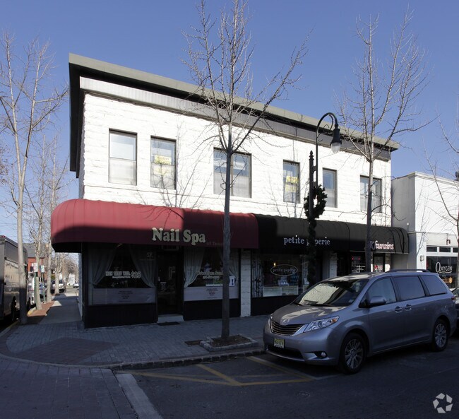
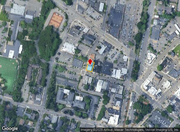
Property Record
29 Washington St, Tenafly, NJ 07670
NEARBY LISTINGS FOR SALE OR LEASE
Property Detail
29 Washington St
61-01010-0000-00009
50X100
Commercialnec
Bergen
X
New Jersey
34003C0212H
9
2024
0.12 AC
2025
Palisades
055201
Northern New Jersey
3,600 SF
New York-Jersey City-White Plains, NY-NJ
DEMOGRAPHICS near 29 Washington St
1 Mile
3 Mile
5 Mile
2024 Total Population
18,285
134,274
545,737
2029 Population
18,337
133,945
534,154
Pop Growth 2024-2029
+ 0.28%
(0.25%)
(2.12%)
Average Age
40
41
41
2024 Total Households
5,918
45,322
203,069
HH Growth 2024-2029
+ 0.27%
(0.28%)
(2.44%)
Median Household Inc
$154,852
$117,698
$85,170
Avg Household Size
3.00
2.90
2.60
2024 Avg HH Vehicles
2.00
2.00
1.00
Median Home Value
$772,686
$518,509
$498,147
Median Year Built
1955
1954
1955
Nearby Places
Map Layers
Map Styles
 Street
 Aerial
- Restaurants
- Banks
- Shops
- Fitness
- Groceries
PUBLIC TRANSPORTATION
COMMUTER RAIL
River Edge (Pascack Valley Line - NJ Transit Commuter Rail (NJ Transit))
DRIVE
WALK
Distance
River Edge (Pascack Valley Line - NJ Transit Commuter Rail (NJ Transit))
8 min
3.9 mi
New Bridge Landing (Pascack Valley Line - NJ Transit Commuter Rail (NJ Transit))
DRIVE
WALK
Distance
New Bridge Landing (Pascack Valley Line - NJ Transit Commuter Rail (NJ Transit))
8 min
4.9 mi
AIRPORT
LaGuardia
DRIVE
WALK
Distance
LaGuardia
32 min
17.7 mi
Newark Liberty International
DRIVE
WALK
Distance
Newark Liberty International
29 min
21.9 mi
Westchester County
DRIVE
WALK
Distance
Westchester County
45 min
29.8 mi
Freight Ports
NY - Red Hook Container Terminal
DRIVE
WALK
Distance
NY - Red Hook Container Terminal
41 min
24.1 mi
SALE & LEASE HISTORY
LISTING DATE
SALE/LEASE

Nov 01, 2024
For Lease
Nearby Properties
Address
Land Use
TOTAL SIZE
Lot Size
Zoning
Address
Land Use
TOTAL SIZE
Lot Size
Zoning
111.37 AC
P1
Address
Land Use
TOTAL SIZE
Lot Size
Zoning
72 AC
P1
Address
Land Use
TOTAL SIZE
Lot Size
Zoning
572,137 SF
14.11 AC
R-D
Address
Land Use
TOTAL SIZE
Lot Size
Zoning
219.71 AC
O
Address
Land Use
TOTAL SIZE
Lot Size
Zoning
100,151 SF
22.13 AC
B2
Address
Land Use
TOTAL SIZE
Lot Size
Zoning
5.22 AC
APT
Address
Land Use
TOTAL SIZE
Lot Size
Zoning
4.54 AC
R-M3
Address
Land Use
TOTAL SIZE
Lot Size
Zoning
15.76 AC
B2
Address
Land Use
TOTAL SIZE
Lot Size
Zoning
185,878 SF
33.44 AC
B
Address
Land Use
TOTAL SIZE
Lot Size
Zoning
Address
Land Use
TOTAL SIZE
Lot Size
Zoning
135.51 AC
RR
Address
Land Use
TOTAL SIZE
Lot Size
Zoning
94.42 AC
P
Address
Land Use
TOTAL SIZE
Lot Size
Zoning
Address
Land Use
TOTAL SIZE
Lot Size
Zoning
225.36 AC
O
Address
Land Use
TOTAL SIZE
Lot Size
Zoning
9.48 AC
RA
Address
Land Use
TOTAL SIZE
Lot Size
Zoning
Address
Land Use
TOTAL SIZE
Lot Size
Zoning
1.12 AC
Address
Land Use
TOTAL SIZE
Lot Size
Zoning
68,824 SF
34.75 AC
R-D
Address
Land Use
TOTAL SIZE
Lot Size
Zoning
7.34 AC
Address
Land Use
TOTAL SIZE
Lot Size
Zoning
28.78 AC
B2
Address
Land Use
TOTAL SIZE
Lot Size
Zoning
163.19 AC
Address
Land Use
TOTAL SIZE
Lot Size
Zoning
173,890 SF
23.80 AC
O
Address
Land Use
TOTAL SIZE
Lot Size
Zoning
21,250 SF
2.37 AC
SBD
Address
Land Use
TOTAL SIZE
Lot Size
Zoning
36.90 AC
MU
Address
Land Use
TOTAL SIZE
Lot Size
Zoning
1.78 AC
L1
Address
Land Use
TOTAL SIZE
Lot Size
Zoning
Address
Land Use
TOTAL SIZE
Lot Size
Zoning
Address
Land Use
TOTAL SIZE
Lot Size
Zoning
10.76 AC
A
Address
Land Use
TOTAL SIZE
Lot Size
Zoning
478 SF
10.45 AC
Address
Land Use
TOTAL SIZE
Lot Size
Zoning
The World's #1 Commercial Real Estate Marketplace
Connect with us
© 2025 CoStar Group
The information above has been obtained from sources believed reliable. While we do not doubt its accuracy we have not verified it and make no guarantee, warranty or representation about it. It is your responsibility to independently confirm its accuracy and completeness. Any projections, opinions, assumptions, or estimates used are for example only and do not represent the current or future performance of the property. The value of this transaction to you depends on tax and other factors which should be evaluated by your tax, financial, and legal advisors. You and your advisors should conduct a careful, independent investigation of the property to determine to your satisfaction the suitability of the property for your needs.