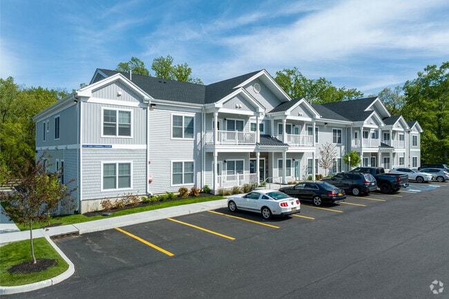
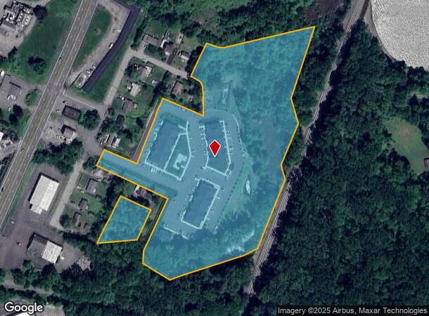
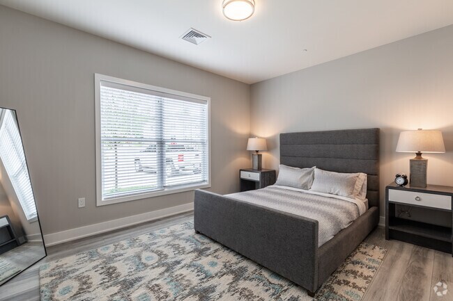
Property Record
29 Cornwall Ct, T O New Windsor, NY 12553
NEARBY LISTINGS FOR SALE OR LEASE
Property Detail
29 Cornwall Ct
New York-Jersey City-White Plains, NY-NJ
LTS 16 16A PLUM POINT HOM
334800-048-000-0002-005.000-0000
Orange
Apartment
New York
X
2.220
36027C0559E
11.60 AC
2024
Outlying Orange County
2024
Northern New Jersey
012800
DEMOGRAPHICS near 29 Cornwall Ct
1 Mile
3 Mile
5 Mile
2024 Total Population
3,968
49,604
93,849
2029 Population
4,092
50,472
95,361
Pop Growth 2024-2029
+ 3.13%
+ 1.75%
+ 1.61%
Average Age
43
39
39
2024 Total Households
1,689
18,630
35,245
HH Growth 2024-2029
+ 3.26%
+ 1.98%
+ 1.66%
Median Household Inc
$63,510
$74,584
$82,073
Avg Household Size
2.30
2.60
2.50
2024 Avg HH Vehicles
2.00
2.00
2.00
Median Home Value
$278,265
$280,925
$320,932
Median Year Built
1975
1958
1960
Nearby Places
- Restaurants
- Banks
- Shops
- Fitness
- Groceries
PUBLIC TRANSPORTATION
COMMUTER RAIL
Beacon Station (Hudson Line - Metro-North Commuter Railroad Company (Metro-North))
DRIVE
WALK
Distance
Beacon Station (Hudson Line - Metro-North Commuter Railroad Company (Metro-North))
14 min
7.6 mi
AIRPORT
New York Stewart International
DRIVE
WALK
Distance
New York Stewart International
16 min
6.8 mi
Freight Ports
NY - Red Hook Container Terminal
DRIVE
WALK
Distance
NY - Red Hook Container Terminal
98 min
70.1 mi
Nearby Properties
Address
Land Use
TOTAL SIZE
Lot Size
Zoning
Address
Land Use
TOTAL SIZE
Lot Size
Zoning
211,240 SF
5.30 AC
WG
Address
Land Use
TOTAL SIZE
Lot Size
Zoning
325,026 SF
6.30 AC
RM
Address
Land Use
TOTAL SIZE
Lot Size
Zoning
88,103 SF
32.60 AC
RH
Address
Land Use
TOTAL SIZE
Lot Size
Zoning
183,335 SF
12.40 AC
Address
Land Use
TOTAL SIZE
Lot Size
Zoning
10,746 SF
11 AC
PWD
Address
Land Use
TOTAL SIZE
Lot Size
Zoning
182,318 SF
9.20 AC
RL
Address
Land Use
TOTAL SIZE
Lot Size
Zoning
364,010 SF
83 AC
R2
Address
Land Use
TOTAL SIZE
Lot Size
Zoning
50 AC
Address
Land Use
TOTAL SIZE
Lot Size
Zoning
176,680 SF
1.28 AC
RM
Address
Land Use
TOTAL SIZE
Lot Size
Zoning
Address
Land Use
TOTAL SIZE
Lot Size
Zoning
59,220 SF
6.40 AC
CD
Address
Land Use
TOTAL SIZE
Lot Size
Zoning
249,379 SF
29.34 AC
Address
Land Use
TOTAL SIZE
Lot Size
Zoning
173,706 SF
11.10 AC
Address
Land Use
TOTAL SIZE
Lot Size
Zoning
101,510 SF
12.80 AC
Address
Land Use
TOTAL SIZE
Lot Size
Zoning
69,006 SF
1.77 AC
DN
Address
Land Use
TOTAL SIZE
Lot Size
Zoning
94,608 SF
3.90 AC
RH
Address
Land Use
TOTAL SIZE
Lot Size
Zoning
107,016 SF
0.79 AC
WG
Address
Land Use
TOTAL SIZE
Lot Size
Zoning
20.60 AC
R1-40
Address
Land Use
TOTAL SIZE
Lot Size
Zoning
57,330 SF
5.40 AC
WG
Address
Land Use
TOTAL SIZE
Lot Size
Zoning
68 AC
WP
Address
Land Use
TOTAL SIZE
Lot Size
Zoning
139,016 SF
3 AC
Address
Land Use
TOTAL SIZE
Lot Size
Zoning
35,012 SF
Address
Land Use
TOTAL SIZE
Lot Size
Zoning
110,686 SF
6.50 AC
RH
Address
Land Use
TOTAL SIZE
Lot Size
Zoning
Address
Land Use
TOTAL SIZE
Lot Size
Zoning
90,584 SF
2.60 AC
RH
Address
Land Use
TOTAL SIZE
Lot Size
Zoning
79,808 SF
2.13 AC
RL
Address
Land Use
TOTAL SIZE
Lot Size
Zoning
16.60 AC
LI
Address
Land Use
TOTAL SIZE
Lot Size
Zoning
25,800 SF
7.90 AC
R4
Address
Land Use
TOTAL SIZE
Lot Size
Zoning
50,096 SF
4.80 AC
Address
Land Use
TOTAL SIZE
Lot Size
Zoning
51,264 SF
1.35 AC
BC
The World's #1 Commercial Real Estate Marketplace
Connect with us
© 2025 CoStar Group
The information above has been obtained from sources believed reliable. While we do not doubt its accuracy we have not verified it and make no guarantee, warranty or representation about it. It is your responsibility to independently confirm its accuracy and completeness. Any projections, opinions, assumptions, or estimates used are for example only and do not represent the current or future performance of the property. The value of this transaction to you depends on tax and other factors which should be evaluated by your tax, financial, and legal advisors. You and your advisors should conduct a careful, independent investigation of the property to determine to your satisfaction the suitability of the property for your needs.