Property Record
29 E Glendale St, Dillon, MT 59725
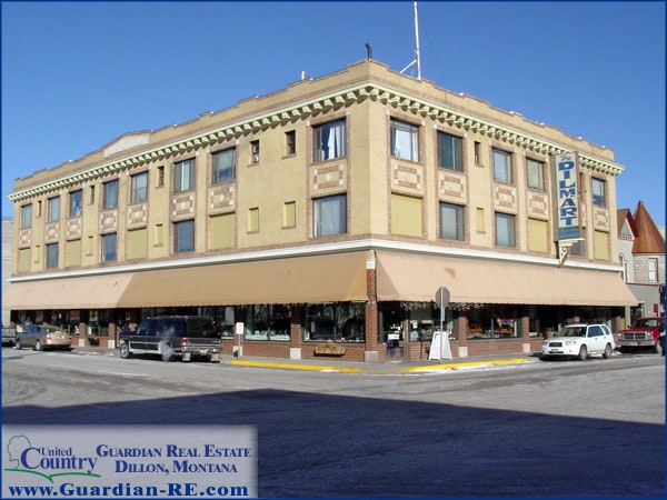

Property Detail
29 E Glendale St
18-0326-19-2-52-01-0000
DILLON ORIGINAL TOWNSITE, S19, T07 S, R08 W, BLOCK 3, LOT 18 - 20, ACRES 0.198
Storebuilding
BEAVERHEAD
B and X Area of moderate flood hazard, usually the area between the limits of the 100-year and 500-year floods.
Montana
2025
18-20
2025
0.20 AC
000300
Butte/Southwestern Montana
24,921 SF
Other Market Areas
NEARBY LISTINGS FOR SALE OR LEASE
DEMOGRAPHICS near 29 E Glendale St
1 mile
3 mile
5 mile
2025 Total Population
4,789
6,845
7,883
2030 Population
5,184
7,336
8,423
Pop Growth 2025-2030
+ 8.25%
+ 7.17%
+ 6.85%
Average Age
40
42
42
2025 Total Households
2,178
3,035
3,456
HH Growth 2025-2030
+ 8.63%
+ 7.55%
+ 7.20%
Median Household Inc
$53,529
$54,875
$55,524
Avg Household Size
2.00
2.10
2.10
2025 Avg HH Vehicles
2.00
2.00
2.00
Median Home Value
$308,333
$320,085
$329,348
Median Year Built
1973
1976
1977
Nearby Places
Map Layers
Map Styles
 Street
 Aerial
Layers
 Traffic
 Biking
Places
Listings with unknown addresses are not visible on the map
- Restaurants
- Banks
- Shops
- Fitness
- Groceries
Nearby Properties
Address
Land Use
TOTAL SIZE
Lot Size
Zoning
Address
Land Use
TOTAL SIZE
Lot Size
Zoning
17,543 SF
3.45 AC
2
Address
Land Use
TOTAL SIZE
Lot Size
Zoning
8,660 SF
2.59 AC
Address
Land Use
TOTAL SIZE
Lot Size
Zoning
26,678 SF
2.11 AC
1
Address
Land Use
TOTAL SIZE
Lot Size
Zoning
43,804 SF
5.90 AC
Address
Land Use
TOTAL SIZE
Lot Size
Zoning
20,192 SF
1.32 AC
Address
Land Use
TOTAL SIZE
Lot Size
Zoning
28,088 SF
2 AC
Address
Land Use
TOTAL SIZE
Lot Size
Zoning
44,539 SF
0.26 AC
1
Address
Land Use
TOTAL SIZE
Lot Size
Zoning
36,980 SF
4 AC
Address
Land Use
TOTAL SIZE
Lot Size
Zoning
27,068 SF
4.28 AC
2
Address
Land Use
TOTAL SIZE
Lot Size
Zoning
23,224 SF
2 AC
Address
Land Use
TOTAL SIZE
Lot Size
Zoning
25,866 SF
9.13 AC
Address
Land Use
TOTAL SIZE
Lot Size
Zoning
17,230 SF
1.37 AC
Address
Land Use
TOTAL SIZE
Lot Size
Zoning
14,780 SF
0.40 AC
Address
Land Use
TOTAL SIZE
Lot Size
Zoning
16,602 SF
3.15 AC
Address
Land Use
TOTAL SIZE
Lot Size
Zoning
30,231 SF
2.59 AC
Address
Land Use
TOTAL SIZE
Lot Size
Zoning
20,064 SF
2.01 AC
Address
Land Use
TOTAL SIZE
Lot Size
Zoning
3,136 SF
3.41 AC
Address
Land Use
TOTAL SIZE
Lot Size
Zoning
7,197 SF
1.44 AC
Address
Land Use
TOTAL SIZE
Lot Size
Zoning
16,708 SF
2.48 AC
Address
Land Use
TOTAL SIZE
Lot Size
Zoning
12,048 SF
3.47 AC
Address
Land Use
TOTAL SIZE
Lot Size
Zoning
6,842 SF
0.22 AC
1
Address
Land Use
TOTAL SIZE
Lot Size
Zoning
6,032 SF
1.39 AC
1
Address
Land Use
TOTAL SIZE
Lot Size
Zoning
6,873 SF
0.66 AC
1
Address
Land Use
TOTAL SIZE
Lot Size
Zoning
8,898 SF
1.49 AC
1
Address
Land Use
TOTAL SIZE
Lot Size
Zoning
4,704 SF
76.51 AC
Address
Land Use
TOTAL SIZE
Lot Size
Zoning
15,648 SF
0.39 AC
Address
Land Use
TOTAL SIZE
Lot Size
Zoning
9,680 SF
0.33 AC
Address
Land Use
TOTAL SIZE
Lot Size
Zoning
23,000 SF
0.33 AC
Address
Land Use
TOTAL SIZE
Lot Size
Zoning
7,992 SF
0.46 AC
1
The World's #1 Commercial Real Estate Marketplace
Connect with us
© 2026 CoStar Group
The information above has been obtained from sources believed reliable. While we do not doubt its accuracy we have not verified it and make no guarantee, warranty or representation about it. It is your responsibility to independently confirm its accuracy and completeness. Any projections, opinions, assumptions, or estimates used are for example only and do not represent the current or future performance of the property. The value of this transaction to you depends on tax and other factors which should be evaluated by your tax, financial, and legal advisors. You and your advisors should conduct a careful, independent investigation of the property to determine to your satisfaction the suitability of the property for your needs.