Property Record
29 E Macarthur St, Sonoma, CA 95476
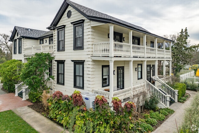

Property Detail
29 E Macarthur St
128-091-008
MAP F3 179
Hotel
Sonoma
AE The base floodplain where base flood elevations are provided. AE Zones are now used on new format FIRMs instead of A1-A30 Zones.
California
2024
5.08 AC
2025
Santa Rosa/Sonoma
150204
North Bay/Santa Rosa
52,919 SF
Santa Rosa-Petaluma, CA
NEARBY LISTINGS FOR SALE OR LEASE
-
-
View all Sonoma listings for sale on LoopNet.com
DEMOGRAPHICS near 29 E Macarthur St
1 mile
3 mile
5 mile
2025 Total Population
9,982
30,017
34,988
2030 Population
10,166
30,089
34,972
Pop Growth 2025-2030
+ 1.84%
+ 0.24%
(0.05%)
Average Age
51
48
48
2025 Total Households
4,704
13,027
14,903
HH Growth 2025-2030
+ 1.89%
+ 0.29%
+ 0.01%
Median Household Inc
$105,968
$109,206
$109,626
Avg Household Size
2.10
2.30
2.30
2025 Avg HH Vehicles
2.00
2.00
2.00
Median Home Value
$1,023,731
$864,780
$871,262
Median Year Built
1977
1976
1976
Nearby Places
Map Layers
Map Styles
 Street
 Aerial
Transit
 Traffic
 Biking
Places
Listings with unknown addresses are not visible on the map
- Restaurants
- Banks
- Shops
- Fitness
- Groceries
PUBLIC TRANSPORTATION
AIRPORT
Charles M Schulz - Sonoma County
Drive
Walk
Distance
Charles M Schulz - Sonoma County
48 min
30.0 mi
Freight Ports
Port of Richmond
Drive
Walk
Distance
Port of Richmond
53 min
37.9 mi
Nearby Properties
Address
Land Use
TOTAL SIZE
Lot Size
Zoning
Address
Land Use
TOTAL SIZE
Lot Size
Zoning
56,325 SF
6 AC
K
Address
Land Use
TOTAL SIZE
Lot Size
Zoning
146,481 SF
9.20 AC
Address
Land Use
TOTAL SIZE
Lot Size
Zoning
126,258 SF
5.83 AC
Address
Land Use
TOTAL SIZE
Lot Size
Zoning
131,876 SF
5.46 AC
R3
Address
Land Use
TOTAL SIZE
Lot Size
Zoning
54,660 SF
1.70 AC
R11UA
Address
Land Use
TOTAL SIZE
Lot Size
Zoning
249,904 SF
16.23 AC
Address
Land Use
TOTAL SIZE
Lot Size
Zoning
Address
Land Use
TOTAL SIZE
Lot Size
Zoning
47,622 SF
4.63 AC
Address
Land Use
TOTAL SIZE
Lot Size
Zoning
59,651 SF
3.28 AC
RR3
Address
Land Use
TOTAL SIZE
Lot Size
Zoning
228,000 SF
11.27 AC
Address
Land Use
TOTAL SIZE
Lot Size
Zoning
234,600 SF
12.01 AC
Address
Land Use
TOTAL SIZE
Lot Size
Zoning
295,680 SF
16.85 AC
Address
Land Use
TOTAL SIZE
Lot Size
Zoning
10,464 SF
15.84 AC
Address
Land Use
TOTAL SIZE
Lot Size
Zoning
39,612 SF
2.02 AC
R11UA
Address
Land Use
TOTAL SIZE
Lot Size
Zoning
134,500 SF
7.94 AC
Address
Land Use
TOTAL SIZE
Lot Size
Zoning
96,820 SF
6.29 AC
Address
Land Use
TOTAL SIZE
Lot Size
Zoning
291,760 SF
16.98 AC
Address
Land Use
TOTAL SIZE
Lot Size
Zoning
40,371 SF
1.52 AC
Address
Land Use
TOTAL SIZE
Lot Size
Zoning
33,986 SF
2.07 AC
R2H
Address
Land Use
TOTAL SIZE
Lot Size
Zoning
78,405 SF
5.31 AC
R1
Address
Land Use
TOTAL SIZE
Lot Size
Zoning
6,718 SF
629.94 AC
LEA100
Address
Land Use
TOTAL SIZE
Lot Size
Zoning
52,445 SF
1.69 AC
AWH
Address
Land Use
TOTAL SIZE
Lot Size
Zoning
1,243 SF
4 AC
AR3
Address
Land Use
TOTAL SIZE
Lot Size
Zoning
39,436 SF
3.41 AC
R3
Address
Land Use
TOTAL SIZE
Lot Size
Zoning
38,736 SF
2.64 AC
M3
Address
Land Use
TOTAL SIZE
Lot Size
Zoning
118,295 SF
8.49 AC
Address
Land Use
TOTAL SIZE
Lot Size
Zoning
40,200 SF
1.80 AC
R3
Address
Land Use
TOTAL SIZE
Lot Size
Zoning
Address
Land Use
TOTAL SIZE
Lot Size
Zoning
16,044 SF
4.50 AC
RR3
The World's #1 Commercial Real Estate Marketplace
Connect with us
© 2026 CoStar Group
The information above has been obtained from sources believed reliable. While we do not doubt its accuracy we have not verified it and make no guarantee, warranty or representation about it. It is your responsibility to independently confirm its accuracy and completeness. Any projections, opinions, assumptions, or estimates used are for example only and do not represent the current or future performance of the property. The value of this transaction to you depends on tax and other factors which should be evaluated by your tax, financial, and legal advisors. You and your advisors should conduct a careful, independent investigation of the property to determine to your satisfaction the suitability of the property for your needs.