Property Record
29 Enterprise Dr, Bunnell, FL 32110


Save to a Folder
{{folder.Name}}
{{folder.ListingIds.length}} Properties
{{folder.ListingIds.length}} Property
Create a New Folder
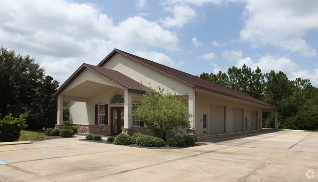
Property Detail
29 Enterprise Dr
22-11-30-5780-00000-0150
TOWN & COUNTRY BUSINESS PARK LOT 15 OR 529 PG 1966, OR 531 PG 207 OR 677 PG 1134 OR 691 PG 905 OR 1269 PG 531
Officebuilding
Flagler
I-C
Florida
B and X Area of moderate flood hazard, usually the area between the limits of the 100-year and 500-year floods.
15
2024
0.52 AC
2025
Flagler County
060206
Other Market Areas
3,478 SF
Deltona-Daytona Beach-Ormond Beach, FL
NEARBY LISTINGS FOR SALE OR LEASE
DEMOGRAPHICS near 29 Enterprise Dr
1 mile
3 mile
5 mile
2025 Total Population
3,714
37,164
80,806
2030 Population
4,237
42,513
92,617
Pop Growth 2025-2030
+ 14.08%
+ 14.39%
+ 14.62%
Average Age
48
46
46
2025 Total Households
1,517
14,651
32,514
HH Growth 2025-2030
+ 14.11%
+ 14.44%
+ 14.67%
Median Household Inc
$67,670
$74,387
$67,356
Avg Household Size
2.40
2.50
2.40
2025 Avg HH Vehicles
2.00
2.00
2.00
Median Home Value
$380,279
$354,172
$364,049
Median Year Built
1999
2001
2001
Nearby Places
Map Layers
Map Styles
 Street
 Aerial
Layers
 Traffic
 Biking
Places
Listings with unknown addresses are not visible on the map
- Restaurants
- Banks
- Shops
- Fitness
- Groceries
PUBLIC TRANSPORTATION
AIRPORT
Daytona Beach International
Drive
Walk
Distance
Daytona Beach International
38 min
31.4 mi
SALE & LEASE HISTORY
LISTING DATE
SALE/LEASE

May 09, 2019
For Sale
Feb 20, 2020
For Sale
Nearby Properties
Address
Land Use
TOTAL SIZE
Lot Size
Zoning
Address
Land Use
TOTAL SIZE
Lot Size
Zoning
76,792 SF
10.05 AC
COM-2
Address
Land Use
TOTAL SIZE
Lot Size
Zoning
298,470 SF
34.44 AC
MFR-2
Address
Land Use
TOTAL SIZE
Lot Size
Zoning
292,473 SF
45.87 AC
PSP
Address
Land Use
TOTAL SIZE
Lot Size
Zoning
209,585 SF
40 AC
MPD
Address
Land Use
TOTAL SIZE
Lot Size
Zoning
236,316 SF
61.38 AC
PSP
Address
Land Use
TOTAL SIZE
Lot Size
Zoning
137,280 SF
64.40 AC
COM-3
Address
Land Use
TOTAL SIZE
Lot Size
Zoning
93,891 SF
5 AC
MFR-2
Address
Land Use
TOTAL SIZE
Lot Size
Zoning
506,883 SF
24.02 AC
COM-2
Address
Land Use
TOTAL SIZE
Lot Size
Zoning
85,307 SF
4.31 AC
IND-1
Address
Land Use
TOTAL SIZE
Lot Size
Zoning
75,297 SF
15.55 AC
PSP
Address
Land Use
TOTAL SIZE
Lot Size
Zoning
94,320 SF
22.19 AC
PSP
Address
Land Use
TOTAL SIZE
Lot Size
Zoning
57,077 SF
5.19 AC
COM-2
Address
Land Use
TOTAL SIZE
Lot Size
Zoning
61,313 SF
7.78 AC
COM-2
Address
Land Use
TOTAL SIZE
Lot Size
Zoning
77,816 SF
5.95 AC
COM-3
Address
Land Use
TOTAL SIZE
Lot Size
Zoning
144,642 SF
10 AC
IND-1
Address
Land Use
TOTAL SIZE
Lot Size
Zoning
33,700 SF
2.89 AC
Address
Land Use
TOTAL SIZE
Lot Size
Zoning
98.85 AC
MFR-2
Address
Land Use
TOTAL SIZE
Lot Size
Zoning
45,381 SF
7.38 AC
PSP
Address
Land Use
TOTAL SIZE
Lot Size
Zoning
101,876 SF
9.22 AC
COM-2
Address
Land Use
TOTAL SIZE
Lot Size
Zoning
88,704 SF
7.96 AC
Address
Land Use
TOTAL SIZE
Lot Size
Zoning
77,370 SF
9.31 AC
COM-2
Address
Land Use
TOTAL SIZE
Lot Size
Zoning
28,335 SF
19.31 AC
PSP
Address
Land Use
TOTAL SIZE
Lot Size
Zoning
27,218 SF
8.43 AC
COM-3
Address
Land Use
TOTAL SIZE
Lot Size
Zoning
45,409 SF
3.90 AC
OFC-2
Address
Land Use
TOTAL SIZE
Lot Size
Zoning
5,264 SF
9.61 AC
PSP
Address
Land Use
TOTAL SIZE
Lot Size
Zoning
73,869 SF
7.93 AC
COM-2
Address
Land Use
TOTAL SIZE
Lot Size
Zoning
32,679 SF
101.42 AC
L-1
Address
Land Use
TOTAL SIZE
Lot Size
Zoning
112,200 SF
49.38 AC
L-1
The World's #1 Commercial Real Estate Marketplace
Connect with us
© 2026 CoStar Group
The information above has been obtained from sources believed reliable. While we do not doubt its accuracy we have not verified it and make no guarantee, warranty or representation about it. It is your responsibility to independently confirm its accuracy and completeness. Any projections, opinions, assumptions, or estimates used are for example only and do not represent the current or future performance of the property. The value of this transaction to you depends on tax and other factors which should be evaluated by your tax, financial, and legal advisors. You and your advisors should conduct a careful, independent investigation of the property to determine to your satisfaction the suitability of the property for your needs.