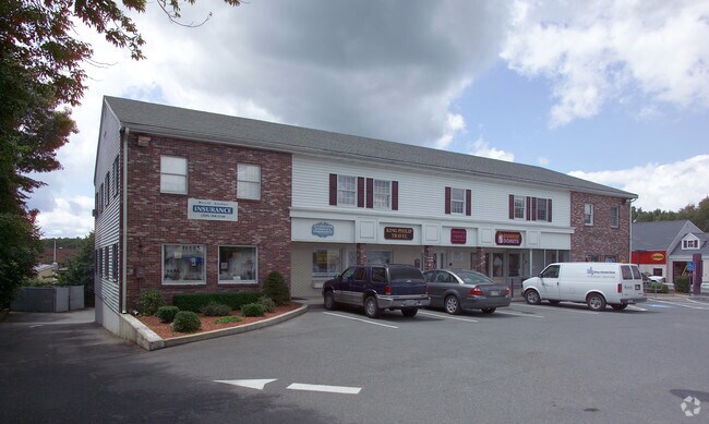
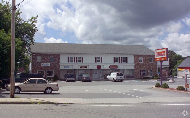
Property Record
29 Franklin St, Wrentham, MA 02093
NEARBY LISTINGS FOR SALE OR LEASE
Property Detail
29 Franklin St
WREN-000010M-000005-000001
Norfolk
Officebuilding
Massachusetts
X
1
25021C0324F
0.86 AC
2025
I-95 Corridor South
2025
Boston
441204
Boston-Cambridge-Newton, MA-NH
9,181 SF
DEMOGRAPHICS near 29 Franklin St
1 Mile
3 Mile
5 Mile
2024 Total Population
3,909
18,734
70,192
2029 Population
3,918
18,686
69,819
Pop Growth 2024-2029
+ 0.23%
(0.26%)
(0.53%)
Average Age
43
42
41
2024 Total Households
1,454
6,910
26,408
HH Growth 2024-2029
+ 0.34%
(0.27%)
(0.60%)
Median Household Inc
$147,383
$127,176
$120,573
Avg Household Size
2.60
2.60
2.60
2024 Avg HH Vehicles
2.00
2.00
2.00
Median Home Value
$576,492
$600,786
$551,936
Median Year Built
1975
1980
1979
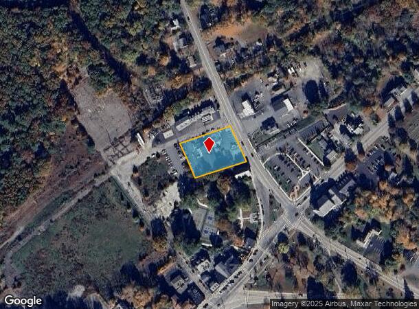
Nearby Places
Map Layers
Map Styles
 Street
 Aerial
- Restaurants
- Banks
- Shops
- Fitness
- Groceries
PUBLIC TRANSPORTATION
COMMUTER RAIL
Franklin (Franklin Line - Massachusetts Bay Transportation Authority Commuter Rail (Purple Line))
DRIVE
WALK
Distance
Franklin (Franklin Line - Massachusetts Bay Transportation Authority Commuter Rail (Purple Line))
8 min
4.1 mi
Norfolk (Franklin Line - Massachusetts Bay Transportation Authority Commuter Rail (Purple Line))
DRIVE
WALK
Distance
Norfolk (Franklin Line - Massachusetts Bay Transportation Authority Commuter Rail (Purple Line))
9 min
5.0 mi
AIRPORT
Rhode Island Tf Green International
DRIVE
WALK
Distance
Rhode Island Tf Green International
49 min
32.6 mi
General Edward Lawrence Logan International
DRIVE
WALK
Distance
General Edward Lawrence Logan International
50 min
34.3 mi
Freight Ports
Port of Boston
DRIVE
WALK
Distance
Port of Boston
48 min
28.9 mi
Nearby Properties
Address
Land Use
TOTAL SIZE
Lot Size
Zoning
Address
Land Use
TOTAL SIZE
Lot Size
Zoning
52,064 SF
87.51 AC
CI
Address
Land Use
TOTAL SIZE
Lot Size
Zoning
14,317 SF
411.17 AC
R-43
Address
Land Use
TOTAL SIZE
Lot Size
Zoning
0.58 AC
Address
Land Use
TOTAL SIZE
Lot Size
Zoning
96,596 SF
17.01 AC
C-2 80
Address
Land Use
TOTAL SIZE
Lot Size
Zoning
231,487 SF
33.15 AC
R-30
Address
Land Use
TOTAL SIZE
Lot Size
Zoning
4.14 AC
Address
Land Use
TOTAL SIZE
Lot Size
Zoning
19,742 SF
58.34 AC
R-43
Address
Land Use
TOTAL SIZE
Lot Size
Zoning
16.99 AC
Address
Land Use
TOTAL SIZE
Lot Size
Zoning
125,778 SF
35.60 AC
Address
Land Use
TOTAL SIZE
Lot Size
Zoning
28.55 AC
CC
Address
Land Use
TOTAL SIZE
Lot Size
Zoning
176,269 SF
40.56 AC
B-2 80
Address
Land Use
TOTAL SIZE
Lot Size
Zoning
142,040 SF
18.16 AC
CI
Address
Land Use
TOTAL SIZE
Lot Size
Zoning
130,500 SF
9.52 AC
Address
Land Use
TOTAL SIZE
Lot Size
Zoning
22 AC
CI
Address
Land Use
TOTAL SIZE
Lot Size
Zoning
3,024 SF
12.47 AC
C-1 80
Address
Land Use
TOTAL SIZE
Lot Size
Zoning
202,800 SF
20.33 AC
Address
Land Use
TOTAL SIZE
Lot Size
Zoning
12.32 AC
Address
Land Use
TOTAL SIZE
Lot Size
Zoning
10,984 SF
8.52 AC
B-1 10
Address
Land Use
TOTAL SIZE
Lot Size
Zoning
132,952 SF
13.64 AC
Address
Land Use
TOTAL SIZE
Lot Size
Zoning
141,049 SF
22.77 AC
CI
Address
Land Use
TOTAL SIZE
Lot Size
Zoning
9,945 SF
16.72 AC
C-2 80
Address
Land Use
TOTAL SIZE
Lot Size
Zoning
102,591 SF
4.21 AC
R-43
Address
Land Use
TOTAL SIZE
Lot Size
Zoning
61,484 SF
5.84 AC
Address
Land Use
TOTAL SIZE
Lot Size
Zoning
4.13 AC
Address
Land Use
TOTAL SIZE
Lot Size
Zoning
95,260 SF
12.80 AC
Address
Land Use
TOTAL SIZE
Lot Size
Zoning
130,854 SF
11.79 AC
C-1 80
Address
Land Use
TOTAL SIZE
Lot Size
Zoning
2,976 SF
9.83 AC
CC
Address
Land Use
TOTAL SIZE
Lot Size
Zoning
58,549 SF
5.82 AC
Address
Land Use
TOTAL SIZE
Lot Size
Zoning
111,345 SF
3.52 AC
CA
Address
Land Use
TOTAL SIZE
Lot Size
Zoning
36,000 SF
4.93 AC
The World's #1 Commercial Real Estate Marketplace
Connect with us
© 2025 CoStar Group
The information above has been obtained from sources believed reliable. While we do not doubt its accuracy we have not verified it and make no guarantee, warranty or representation about it. It is your responsibility to independently confirm its accuracy and completeness. Any projections, opinions, assumptions, or estimates used are for example only and do not represent the current or future performance of the property. The value of this transaction to you depends on tax and other factors which should be evaluated by your tax, financial, and legal advisors. You and your advisors should conduct a careful, independent investigation of the property to determine to your satisfaction the suitability of the property for your needs.