Property Record
Centre St, Lynn, MA 01905
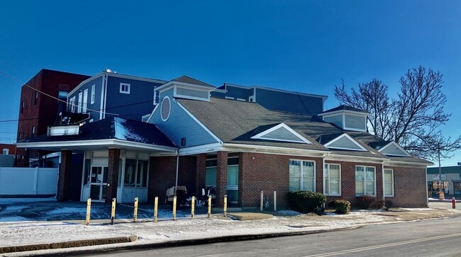

This Property Is For Sale
NEARBY LISTINGS FOR SALE OR LEASE
-
-
View all Lynn listings for sale on LoopNet.com
Property Detail
Centre St
LYNN-000037-000727-000028
Essex
Parkinglot
Massachusetts
X
28
25025C0029J
0.17 AC
2025
Saugus/Lynn
2025
Boston
205800
Boston-Cambridge-Newton, MA-NH
DEMOGRAPHICS near Centre St
1 Mile
3 Mile
5 Mile
2024 Total Population
41,285
134,343
304,150
2029 Population
41,866
136,173
309,268
Pop Growth 2024-2029
+ 1.41%
+ 1.36%
+ 1.68%
Average Age
36
39
40
2024 Total Households
13,702
48,499
112,925
HH Growth 2024-2029
+ 1.65%
+ 1.45%
+ 1.83%
Median Household Inc
$59,412
$77,126
$89,263
Avg Household Size
2.80
2.70
2.60
2024 Avg HH Vehicles
1.00
2.00
2.00
Median Home Value
$488,115
$607,523
$656,622
Median Year Built
1948
1949
1954
Nearby Places
Map Layers
Map Styles
 Street
 Aerial
- Restaurants
- Banks
- Shops
- Fitness
- Groceries
PUBLIC TRANSPORTATION
COMMUTER RAIL
Lynn (Newburyport/Rockport Line - Massachusetts Bay Transportation Authority Commuter Rail (Purple Line))
DRIVE
WALK
Distance
Lynn (Newburyport/Rockport Line - Massachusetts Bay Transportation Authority Commuter Rail (Purple Line))
2 min
20 min
1.0 mi
DRIVE
WALK
Distance
4 min
1.5 mi
AIRPORT
General Edward Lawrence Logan International
DRIVE
WALK
Distance
General Edward Lawrence Logan International
16 min
8.8 mi
Manchester Boston Regional
DRIVE
WALK
Distance
Manchester Boston Regional
71 min
49.4 mi
Freight Ports
Port of Boston
DRIVE
WALK
Distance
Port of Boston
22 min
11.5 mi
Nearby Properties
Address
Land Use
TOTAL SIZE
Lot Size
Zoning
Address
Land Use
TOTAL SIZE
Lot Size
Zoning
195,446 SF
12.98 AC
R2
Address
Land Use
TOTAL SIZE
Lot Size
Zoning
9.73 AC
R5
Address
Land Use
TOTAL SIZE
Lot Size
Zoning
224,840 SF
2.18 AC
RC1
Address
Land Use
TOTAL SIZE
Lot Size
Zoning
277,750 SF
13.47 AC
LI
Address
Land Use
TOTAL SIZE
Lot Size
Zoning
11,840 SF
0.67 AC
CBD
Address
Land Use
TOTAL SIZE
Lot Size
Zoning
4.51 AC
R5
Address
Land Use
TOTAL SIZE
Lot Size
Zoning
269,070 SF
21.74 AC
NA
Address
Land Use
TOTAL SIZE
Lot Size
Zoning
345,298 SF
5.74 AC
WF1
Address
Land Use
TOTAL SIZE
Lot Size
Zoning
190,000 SF
24.42 AC
N/A
Address
Land Use
TOTAL SIZE
Lot Size
Zoning
8.47 AC
PC
Address
Land Use
TOTAL SIZE
Lot Size
Zoning
303,568 SF
1.11 AC
LI
Address
Land Use
TOTAL SIZE
Lot Size
Zoning
8.74 AC
WF1A
Address
Land Use
TOTAL SIZE
Lot Size
Zoning
151.89 AC
PC
Address
Land Use
TOTAL SIZE
Lot Size
Zoning
169,840 SF
16.70 AC
NA
Address
Land Use
TOTAL SIZE
Lot Size
Zoning
514,553 SF
57.16 AC
R4
Address
Land Use
TOTAL SIZE
Lot Size
Zoning
24.85 AC
R4
Address
Land Use
TOTAL SIZE
Lot Size
Zoning
123,903 SF
0.88 AC
CBD
Address
Land Use
TOTAL SIZE
Lot Size
Zoning
3.22 AC
R5
Address
Land Use
TOTAL SIZE
Lot Size
Zoning
15,240 SF
11.49 AC
WF3
Address
Land Use
TOTAL SIZE
Lot Size
Zoning
208,440 SF
1.49 AC
GB
Address
Land Use
TOTAL SIZE
Lot Size
Zoning
5.40 AC
R5
Address
Land Use
TOTAL SIZE
Lot Size
Zoning
98,516 SF
5.01 AC
R1
Address
Land Use
TOTAL SIZE
Lot Size
Zoning
25.02 AC
WF1A
Address
Land Use
TOTAL SIZE
Lot Size
Zoning
68,296 SF
6.01 AC
R2
Address
Land Use
TOTAL SIZE
Lot Size
Zoning
84,681 SF
3.53 AC
R5
Address
Land Use
TOTAL SIZE
Lot Size
Zoning
76,589 SF
4.57 AC
R4
Address
Land Use
TOTAL SIZE
Lot Size
Zoning
65.50 AC
WF1
Address
Land Use
TOTAL SIZE
Lot Size
Zoning
2.88 AC
R5
Address
Land Use
TOTAL SIZE
Lot Size
Zoning
3.02 AC
RC1
The World's #1 Commercial Real Estate Marketplace
Connect with us
© 2026 CoStar Group
The information above has been obtained from sources believed reliable. While we do not doubt its accuracy we have not verified it and make no guarantee, warranty or representation about it. It is your responsibility to independently confirm its accuracy and completeness. Any projections, opinions, assumptions, or estimates used are for example only and do not represent the current or future performance of the property. The value of this transaction to you depends on tax and other factors which should be evaluated by your tax, financial, and legal advisors. You and your advisors should conduct a careful, independent investigation of the property to determine to your satisfaction the suitability of the property for your needs.