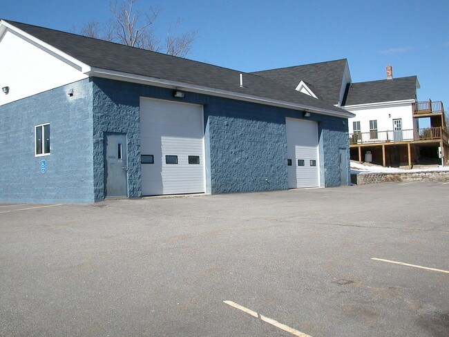
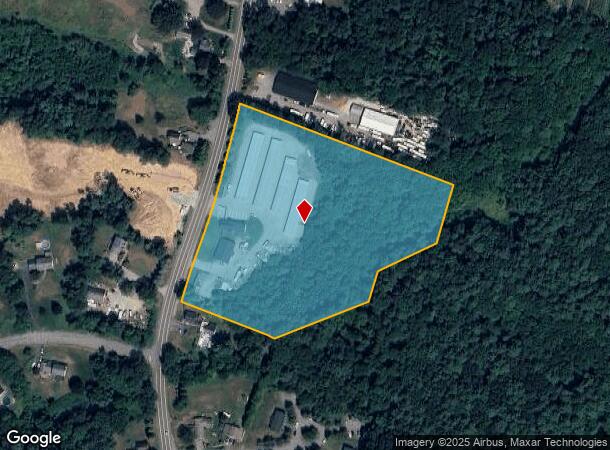
Property Record
29 Newton Rd, Plaistow, NH 03865

NEARBY LISTINGS FOR SALE OR LEASE
-
-
-
-
-
No Photo
-
-
-
View all Plaistow listings for sale on LoopNet.com
Property Detail
29 Newton Rd
PLSW-000066-000020
Rockingham
Commercialnec
New Hampshire
A
000
25009C0080F
7.29 AC
2024
Rockingham
2024
Boston
101101
Boston-Cambridge-Newton, MA-NH
2,942 SF
DEMOGRAPHICS near 29 Newton Rd
1 mile
3 mile
5 mile
2024 Total Population
2,161
41,622
93,646
2029 Population
2,182
41,423
93,288
Pop Growth 2024-2029
+ 0.97%
(0.48%)
(0.38%)
Average Age
44
41
41
2024 Total Households
831
16,432
36,610
HH Growth 2024-2029
+ 0.72%
(0.52%)
(0.46%)
Median Household Inc
$106,604
$76,377
$87,338
Avg Household Size
2.50
2.40
2.50
2024 Avg HH Vehicles
2.00
2.00
2.00
Median Home Value
$451,775
$399,718
$413,761
Median Year Built
1983
1959
1969
Nearby Places
Map Layers
Map Styles
 Street
 Aerial
Transit
 Traffic
 Biking
Places
Listings with unknown addresses are not visible on the map
- Restaurants
- Banks
- Shops
- Fitness
- Groceries
PUBLIC TRANSPORTATION
COMMUTER RAIL
Haverhill (Haverhill Line - Massachusetts Bay Transportation Authority Commuter Rail (Purple Line))
Drive
Walk
Distance
Haverhill (Haverhill Line - Massachusetts Bay Transportation Authority Commuter Rail (Purple Line))
7 min
3.4 mi
Bradford (Haverhill Line - Massachusetts Bay Transportation Authority Commuter Rail (Purple Line))
Drive
Walk
Distance
Bradford (Haverhill Line - Massachusetts Bay Transportation Authority Commuter Rail (Purple Line))
8 min
3.9 mi
AIRPORT
Portsmouth International at Pease
Drive
Walk
Distance
Portsmouth International at Pease
41 min
29.3 mi
Manchester Boston Regional
Drive
Walk
Distance
Manchester Boston Regional
53 min
34.4 mi
Freight Ports
Port of Boston
Drive
Walk
Distance
Port of Boston
58 min
41.2 mi
Nearby Properties
Address
Land Use
TOTAL SIZE
Lot Size
Zoning
Address
Land Use
TOTAL SIZE
Lot Size
Zoning
481,367 SF
166.72 AC
Address
Land Use
TOTAL SIZE
Lot Size
Zoning
109.09 AC
Address
Land Use
TOTAL SIZE
Lot Size
Zoning
32.32 AC
Address
Land Use
TOTAL SIZE
Lot Size
Zoning
232,420 SF
4.58 AC
Address
Land Use
TOTAL SIZE
Lot Size
Zoning
Address
Land Use
TOTAL SIZE
Lot Size
Zoning
195,120 SF
9.05 AC
Address
Land Use
TOTAL SIZE
Lot Size
Zoning
169,340 SF
14.95 AC
C-1
Address
Land Use
TOTAL SIZE
Lot Size
Zoning
21.91 AC
Address
Land Use
TOTAL SIZE
Lot Size
Zoning
121,231 SF
1.11 AC
Address
Land Use
TOTAL SIZE
Lot Size
Zoning
125,627 SF
46.02 AC
C-1
Address
Land Use
TOTAL SIZE
Lot Size
Zoning
200,081 SF
1.95 AC
Address
Land Use
TOTAL SIZE
Lot Size
Zoning
72,019 SF
10.74 AC
Address
Land Use
TOTAL SIZE
Lot Size
Zoning
35,633 SF
19.15 AC
C-1
Address
Land Use
TOTAL SIZE
Lot Size
Zoning
2,400 SF
4 AC
MDR
Address
Land Use
TOTAL SIZE
Lot Size
Zoning
106,323 SF
2.05 AC
Address
Land Use
TOTAL SIZE
Lot Size
Zoning
102,352 SF
19.50 AC
Address
Land Use
TOTAL SIZE
Lot Size
Zoning
69,094 SF
0.54 AC
Address
Land Use
TOTAL SIZE
Lot Size
Zoning
88,943 SF
2.43 AC
Address
Land Use
TOTAL SIZE
Lot Size
Zoning
63,461 SF
7.61 AC
Address
Land Use
TOTAL SIZE
Lot Size
Zoning
74,723 SF
5.15 AC
Address
Land Use
TOTAL SIZE
Lot Size
Zoning
8.54 AC
RH
Address
Land Use
TOTAL SIZE
Lot Size
Zoning
63,258 SF
8.01 AC
RH
Address
Land Use
TOTAL SIZE
Lot Size
Zoning
90,779 SF
1.74 AC
Address
Land Use
TOTAL SIZE
Lot Size
Zoning
16.87 AC
Address
Land Use
TOTAL SIZE
Lot Size
Zoning
115,088 SF
27.42 AC
Address
Land Use
TOTAL SIZE
Lot Size
Zoning
90,836 SF
0.75 AC
Address
Land Use
TOTAL SIZE
Lot Size
Zoning
79,928 SF
0.26 AC
Address
Land Use
TOTAL SIZE
Lot Size
Zoning
2.09 AC
LDR
Address
Land Use
TOTAL SIZE
Lot Size
Zoning
51.41 AC
Address
Land Use
TOTAL SIZE
Lot Size
Zoning
67,231 SF
1.44 AC
The World's #1 Commercial Real Estate Marketplace
Connect with us
© 2026 CoStar Group
The information above has been obtained from sources believed reliable. While we do not doubt its accuracy we have not verified it and make no guarantee, warranty or representation about it. It is your responsibility to independently confirm its accuracy and completeness. Any projections, opinions, assumptions, or estimates used are for example only and do not represent the current or future performance of the property. The value of this transaction to you depends on tax and other factors which should be evaluated by your tax, financial, and legal advisors. You and your advisors should conduct a careful, independent investigation of the property to determine to your satisfaction the suitability of the property for your needs.