Property Record
29 Palms Hwy, 29 Palms, CA 92277
NEARBY LISTINGS FOR SALE OR LEASE
Property Detail
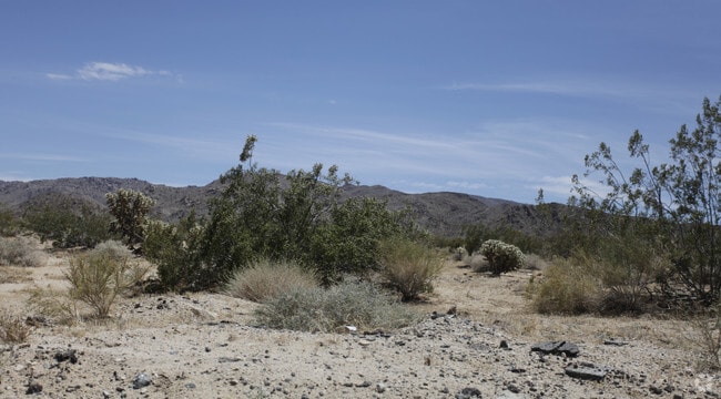
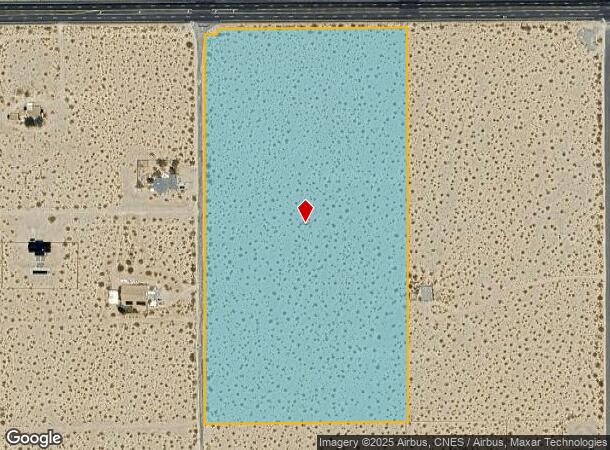
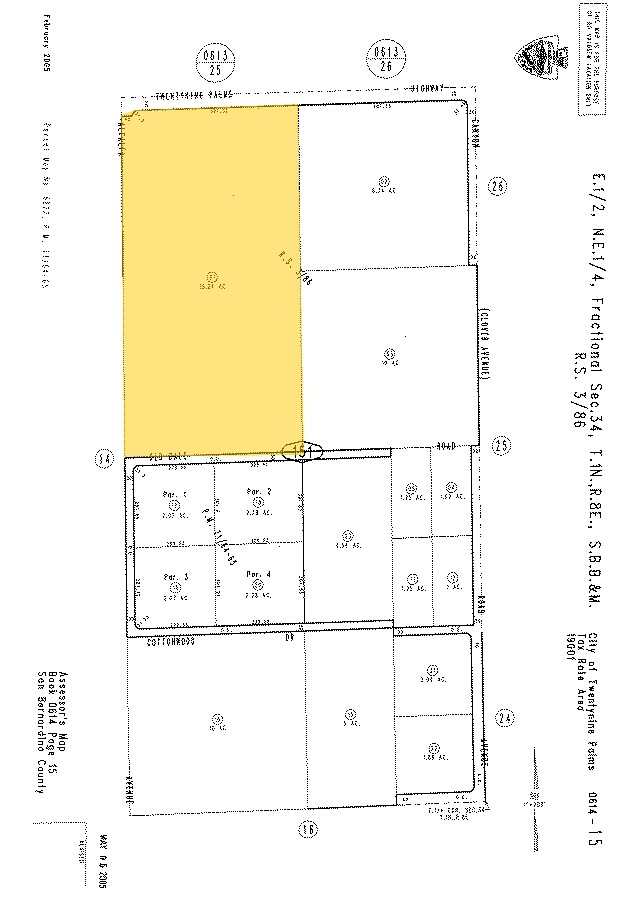
29 Palms Hwy
0614-151-01
W 1/2 NE 1/4 NE 1/4 SEC 34 TP 1N R 8E EX HWY
Vacantlandnec
San Bernardino
X
California
06071C8175H
20 AC
2024
Twentynine Palms
2025
Inland Empire (California)
010422
Riverside-San Bernardino-Ontario, CA
532 SF
DEMOGRAPHICS near 29 Palms Hwy
1 Mile
3 Mile
5 Mile
2024 Total Population
580
7,286
15,920
2029 Population
601
7,528
16,533
Pop Growth 2024-2029
+ 3.62%
+ 3.32%
+ 3.85%
Average Age
42
38
36
2024 Total Households
241
2,894
6,516
HH Growth 2024-2029
+ 3.73%
+ 3.32%
+ 3.88%
Median Household Inc
$80,000
$59,398
$51,664
Avg Household Size
2.40
2.50
2.40
2024 Avg HH Vehicles
2.00
2.00
2.00
Median Home Value
$367,391
$203,521
$216,971
Median Year Built
1979
1980
1983
Nearby Places
Map Layers
Map Styles
 Street
 Aerial
- Restaurants
- Banks
- Shops
- Fitness
- Groceries
Nearby Properties
Address
Land Use
TOTAL SIZE
Lot Size
Zoning
Address
Land Use
TOTAL SIZE
Lot Size
Zoning
49,866 SF
3.63 AC
Address
Land Use
TOTAL SIZE
Lot Size
Zoning
47,763 SF
1.43 AC
Address
Land Use
TOTAL SIZE
Lot Size
Zoning
79,214 SF
4.93 AC
Address
Land Use
TOTAL SIZE
Lot Size
Zoning
17,394 SF
1.87 AC
Address
Land Use
TOTAL SIZE
Lot Size
Zoning
16,000 SF
2.78 AC
Address
Land Use
TOTAL SIZE
Lot Size
Zoning
36,478 SF
2.30 AC
Address
Land Use
TOTAL SIZE
Lot Size
Zoning
12,153 SF
1.40 AC
Address
Land Use
TOTAL SIZE
Lot Size
Zoning
35,826 SF
2.70 AC
Address
Land Use
TOTAL SIZE
Lot Size
Zoning
2,121 SF
0.32 AC
Address
Land Use
TOTAL SIZE
Lot Size
Zoning
7,225 SF
1.18 AC
Address
Land Use
TOTAL SIZE
Lot Size
Zoning
37,380 SF
3.03 AC
Address
Land Use
TOTAL SIZE
Lot Size
Zoning
2,239 SF
1.12 AC
Address
Land Use
TOTAL SIZE
Lot Size
Zoning
15,506 SF
1.53 AC
Address
Land Use
TOTAL SIZE
Lot Size
Zoning
15,136 SF
0.76 AC
Address
Land Use
TOTAL SIZE
Lot Size
Zoning
2,662 SF
0.19 AC
Address
Land Use
TOTAL SIZE
Lot Size
Zoning
23,514 SF
111 AC
Address
Land Use
TOTAL SIZE
Lot Size
Zoning
7,886 SF
6.43 AC
Address
Land Use
TOTAL SIZE
Lot Size
Zoning
218.80 AC
RC
Address
Land Use
TOTAL SIZE
Lot Size
Zoning
19,902 SF
1.32 AC
Address
Land Use
TOTAL SIZE
Lot Size
Zoning
8,648 SF
8.68 AC
Address
Land Use
TOTAL SIZE
Lot Size
Zoning
2,710 SF
1.29 AC
Address
Land Use
TOTAL SIZE
Lot Size
Zoning
2,565 SF
0.56 AC
Address
Land Use
TOTAL SIZE
Lot Size
Zoning
1,767 SF
0.57 AC
Address
Land Use
TOTAL SIZE
Lot Size
Zoning
2,171 SF
20 AC
Address
Land Use
TOTAL SIZE
Lot Size
Zoning
7,476 SF
0.76 AC
Address
Land Use
TOTAL SIZE
Lot Size
Zoning
2,200 SF
0.60 AC
Address
Land Use
TOTAL SIZE
Lot Size
Zoning
5,327 SF
0.12 AC
Address
Land Use
TOTAL SIZE
Lot Size
Zoning
3,908 SF
2.12 AC
Address
Land Use
TOTAL SIZE
Lot Size
Zoning
15,900 SF
1.32 AC
Address
Land Use
TOTAL SIZE
Lot Size
Zoning
27.25 AC
The World's #1 Commercial Real Estate Marketplace
Connect with us
© 2026 CoStar Group
The information above has been obtained from sources believed reliable. While we do not doubt its accuracy we have not verified it and make no guarantee, warranty or representation about it. It is your responsibility to independently confirm its accuracy and completeness. Any projections, opinions, assumptions, or estimates used are for example only and do not represent the current or future performance of the property. The value of this transaction to you depends on tax and other factors which should be evaluated by your tax, financial, and legal advisors. You and your advisors should conduct a careful, independent investigation of the property to determine to your satisfaction the suitability of the property for your needs.