Property Record
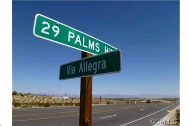
29 Palms Hwy, 29 Palms, CA 92277


NEARBY LISTINGS FOR SALE OR LEASE
Property Detail
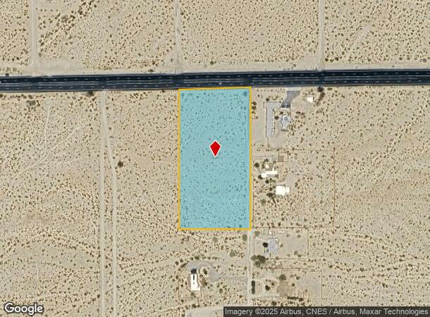
29 Palms Hwy
Riverside-San Bernardino-Ontario, CA
W 1/2 NW 1/4 NE 1/4 NE 1/4 SEC 35 TP 1N R 8E EX HWY
0614-241-07
San Bernardino
Vacantlandnec
California
X
14
06071C8190J
4.93 AC
2024
Twentynine Palms
2025
Inland Empire (California)
010422
DEMOGRAPHICS near 29 Palms Hwy
1 Mile
3 Mile
5 Mile
2024 Total Population
1,343
9,081
18,547
2029 Population
1,387
9,396
19,275
Pop Growth 2024-2029
+ 3.28%
+ 3.47%
+ 3.93%
Average Age
38
37
36
2024 Total Households
540
3,633
7,608
HH Growth 2024-2029
+ 3.15%
+ 3.47%
+ 3.96%
Median Household Inc
$58,191
$56,671
$51,509
Avg Household Size
2.50
2.50
2.40
2024 Avg HH Vehicles
2.00
2.00
2.00
Median Home Value
$200,980
$207,270
$199,999
Median Year Built
1983
1981
1984
Nearby Places
Map Layers
Map Styles
 Street
 Aerial
- Restaurants
- Banks
- Shops
- Fitness
- Groceries
SALE & LEASE HISTORY
LISTING DATE
SALE/LEASE

Sep 24, 2016
For Sale
Apr 21, 2017
For Sale
Nearby Properties
Address
Land Use
TOTAL SIZE
Lot Size
Zoning
Address
Land Use
TOTAL SIZE
Lot Size
Zoning
49,866 SF
3.63 AC
Address
Land Use
TOTAL SIZE
Lot Size
Zoning
47,763 SF
1.43 AC
Address
Land Use
TOTAL SIZE
Lot Size
Zoning
79,214 SF
4.93 AC
Address
Land Use
TOTAL SIZE
Lot Size
Zoning
17,394 SF
1.87 AC
Address
Land Use
TOTAL SIZE
Lot Size
Zoning
16,000 SF
2.78 AC
Address
Land Use
TOTAL SIZE
Lot Size
Zoning
36,478 SF
2.30 AC
Address
Land Use
TOTAL SIZE
Lot Size
Zoning
12,153 SF
1.40 AC
Address
Land Use
TOTAL SIZE
Lot Size
Zoning
35,826 SF
2.70 AC
Address
Land Use
TOTAL SIZE
Lot Size
Zoning
960 SF
3.22 AC
Address
Land Use
TOTAL SIZE
Lot Size
Zoning
2,121 SF
0.32 AC
Address
Land Use
TOTAL SIZE
Lot Size
Zoning
7,225 SF
1.18 AC
Address
Land Use
TOTAL SIZE
Lot Size
Zoning
37,380 SF
3.03 AC
Address
Land Use
TOTAL SIZE
Lot Size
Zoning
2,239 SF
1.12 AC
Address
Land Use
TOTAL SIZE
Lot Size
Zoning
38,453 SF
6 AC
Address
Land Use
TOTAL SIZE
Lot Size
Zoning
15,506 SF
1.53 AC
Address
Land Use
TOTAL SIZE
Lot Size
Zoning
15,136 SF
0.76 AC
Address
Land Use
TOTAL SIZE
Lot Size
Zoning
2,662 SF
0.19 AC
Address
Land Use
TOTAL SIZE
Lot Size
Zoning
3,146 SF
1.16 AC
Address
Land Use
TOTAL SIZE
Lot Size
Zoning
7,886 SF
6.43 AC
Address
Land Use
TOTAL SIZE
Lot Size
Zoning
2,880 SF
0.79 AC
Address
Land Use
TOTAL SIZE
Lot Size
Zoning
218.80 AC
RC
Address
Land Use
TOTAL SIZE
Lot Size
Zoning
19,902 SF
1.32 AC
Address
Land Use
TOTAL SIZE
Lot Size
Zoning
6,020 SF
3.45 AC
Address
Land Use
TOTAL SIZE
Lot Size
Zoning
8,648 SF
8.68 AC
Address
Land Use
TOTAL SIZE
Lot Size
Zoning
18,544 SF
9.03 AC
Address
Land Use
TOTAL SIZE
Lot Size
Zoning
2,710 SF
1.29 AC
Address
Land Use
TOTAL SIZE
Lot Size
Zoning
5,000 SF
0.82 AC
Address
Land Use
TOTAL SIZE
Lot Size
Zoning
17,511 SF
0.19 AC
Address
Land Use
TOTAL SIZE
Lot Size
Zoning
980 SF
1.01 AC
Address
Land Use
TOTAL SIZE
Lot Size
Zoning
6,000 SF
2.03 AC
The World's #1 Commercial Real Estate Marketplace
Connect with us
© 2026 CoStar Group
The information above has been obtained from sources believed reliable. While we do not doubt its accuracy we have not verified it and make no guarantee, warranty or representation about it. It is your responsibility to independently confirm its accuracy and completeness. Any projections, opinions, assumptions, or estimates used are for example only and do not represent the current or future performance of the property. The value of this transaction to you depends on tax and other factors which should be evaluated by your tax, financial, and legal advisors. You and your advisors should conduct a careful, independent investigation of the property to determine to your satisfaction the suitability of the property for your needs.