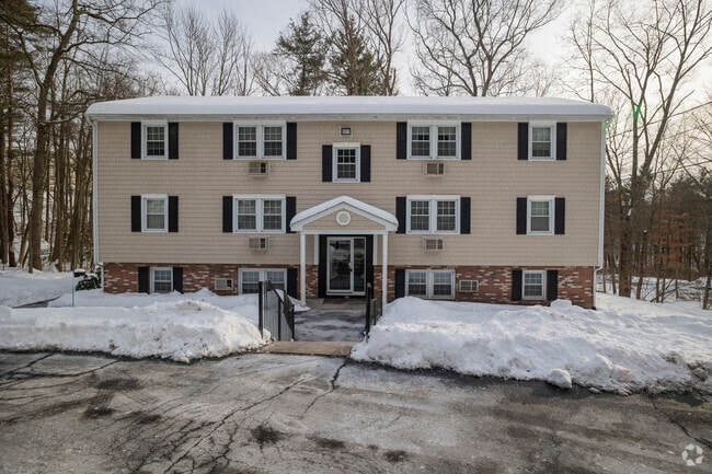
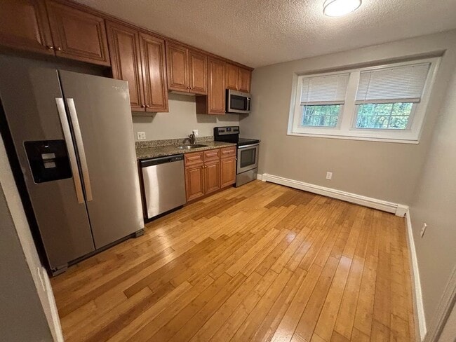
Property Record
29 Stonehenge Rd, Londonderry, NH 03053
NEARBY LISTINGS FOR SALE OR LEASE
-
-
View all Londonderry listings for sale on LoopNet.com
Property Detail
29 Stonehenge Rd
LOND-000012-000000-000124-000005
Rockingham
Apartment
New Hampshire
X
124-12
33011C0395D
2.12 AC
2024
Suburban Rockingham County
2024
Boston
003703
Boston-Cambridge-Newton, MA-NH
4,605 SF
DEMOGRAPHICS near 29 Stonehenge Rd
1 Mile
3 Mile
5 Mile
2024 Total Population
3,375
23,888
66,062
2029 Population
3,632
25,575
69,880
Pop Growth 2024-2029
+ 7.61%
+ 7.06%
+ 5.78%
Average Age
41
42
42
2024 Total Households
1,301
9,311
25,785
HH Growth 2024-2029
+ 7.61%
+ 6.97%
+ 5.72%
Median Household Inc
$125,334
$103,884
$100,865
Avg Household Size
2.60
2.50
2.50
2024 Avg HH Vehicles
2.00
2.00
2.00
Median Home Value
$420,700
$385,797
$370,353
Median Year Built
1987
1983
1983
Nearby Places
Map Layers
Map Styles
 Street
 Aerial
- Restaurants
- Banks
- Shops
- Fitness
- Groceries
PUBLIC TRANSPORTATION
AIRPORT
Manchester Boston Regional
DRIVE
WALK
Distance
Manchester Boston Regional
15 min
6.0 mi
Freight Ports
Port of Boston
DRIVE
WALK
Distance
Port of Boston
72 min
47.6 mi
SALE & LEASE HISTORY
LISTING DATE
SALE/LEASE

Aug 16, 2024
For Sale
Nearby Properties
Address
Land Use
TOTAL SIZE
Lot Size
Zoning
Address
Land Use
TOTAL SIZE
Lot Size
Zoning
15.44 AC
AR-I
Address
Land Use
TOTAL SIZE
Lot Size
Zoning
1,710 SF
65 AC
AR-I
Address
Land Use
TOTAL SIZE
Lot Size
Zoning
214,583 SF
110.37 AC
AR-I
Address
Land Use
TOTAL SIZE
Lot Size
Zoning
50.47 AC
GB
Address
Land Use
TOTAL SIZE
Lot Size
Zoning
180,600 SF
14.19 AC
IND-I
Address
Land Use
TOTAL SIZE
Lot Size
Zoning
366,008 SF
41.69 AC
IND-I
Address
Land Use
TOTAL SIZE
Lot Size
Zoning
186,072 SF
18.64 AC
C-I
Address
Land Use
TOTAL SIZE
Lot Size
Zoning
487,970 SF
79.74 AC
IND-I
Address
Land Use
TOTAL SIZE
Lot Size
Zoning
133,188 SF
1.53 AC
AR-I
Address
Land Use
TOTAL SIZE
Lot Size
Zoning
23.03 AC
GC
Address
Land Use
TOTAL SIZE
Lot Size
Zoning
166,979 SF
22.08 AC
MHDR
Address
Land Use
TOTAL SIZE
Lot Size
Zoning
119,139 SF
25.87 AC
IND-I
Address
Land Use
TOTAL SIZE
Lot Size
Zoning
244,637 SF
27.28 AC
IND-II
Address
Land Use
TOTAL SIZE
Lot Size
Zoning
117,412 SF
12.86 AC
C-II
Address
Land Use
TOTAL SIZE
Lot Size
Zoning
33.45 AC
IND4
Address
Land Use
TOTAL SIZE
Lot Size
Zoning
30.26 AC
C-I
Address
Land Use
TOTAL SIZE
Lot Size
Zoning
154,551 SF
55.80 AC
IND4
Address
Land Use
TOTAL SIZE
Lot Size
Zoning
31.14 AC
AR-I
Address
Land Use
TOTAL SIZE
Lot Size
Zoning
195,610 SF
20.49 AC
C-I
Address
Land Use
TOTAL SIZE
Lot Size
Zoning
22.09 AC
AR-I
Address
Land Use
TOTAL SIZE
Lot Size
Zoning
90,406 SF
24.78 AC
AR-I
Address
Land Use
TOTAL SIZE
Lot Size
Zoning
79,447 SF
6.83 AC
GC2
Address
Land Use
TOTAL SIZE
Lot Size
Zoning
69,266 SF
6.02 AC
MHDR
Address
Land Use
TOTAL SIZE
Lot Size
Zoning
42,956 SF
2.31 AC
Address
Land Use
TOTAL SIZE
Lot Size
Zoning
125,060 SF
8.76 AC
IND-I
Address
Land Use
TOTAL SIZE
Lot Size
Zoning
16.50 AC
C-II
Address
Land Use
TOTAL SIZE
Lot Size
Zoning
121,108 SF
14.89 AC
IND4
Address
Land Use
TOTAL SIZE
Lot Size
Zoning
34,442 SF
99.29 AC
AR-I
Address
Land Use
TOTAL SIZE
Lot Size
Zoning
3.09 AC
IND4
Address
Land Use
TOTAL SIZE
Lot Size
Zoning
2.73 AC
IND4
The World's #1 Commercial Real Estate Marketplace
Connect with us
© 2025 CoStar Group
The information above has been obtained from sources believed reliable. While we do not doubt its accuracy we have not verified it and make no guarantee, warranty or representation about it. It is your responsibility to independently confirm its accuracy and completeness. Any projections, opinions, assumptions, or estimates used are for example only and do not represent the current or future performance of the property. The value of this transaction to you depends on tax and other factors which should be evaluated by your tax, financial, and legal advisors. You and your advisors should conduct a careful, independent investigation of the property to determine to your satisfaction the suitability of the property for your needs.