Property Record
29 Stuart Rd, Lake Placid, FL 33852


Property Detail
29 Stuart Rd
Sebring, FL
SUB OF LAKE GROVES LOTS 168-169-170 + 171 PER PB 1-PGS 52 + 53 ALL SUBDIVISION 35.91 ACRES (STUART BLOCK)
C-12-37-29-020-00G0-0010
HIGHLANDS
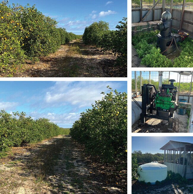
Orchard
Florida
AU
168
B and X Area of moderate flood hazard, usually the area between the limits of the 100-year and 500-year floods.
35.91 AC
2024
Florida Central South Area
2025
Other Market Areas
961604
NEARBY LISTINGS FOR SALE OR LEASE
DEMOGRAPHICS near 29 Stuart Rd
1 mile
3 mile
5 mile
2025 Total Population
730
10,867
20,036
2030 Population
790
11,726
21,746
Pop Growth 2025-2030
+ 8.22%
+ 7.90%
+ 8.53%
Average Age
48
49
50
2025 Total Households
317
4,753
8,803
HH Growth 2025-2030
+ 8.20%
+ 7.99%
+ 8.68%
Median Household Inc
$68,303
$56,610
$55,086
Avg Household Size
2.30
2.20
2.20
2025 Avg HH Vehicles
2.00
2.00
2.00
Median Home Value
$324,074
$252,612
$247,719
Median Year Built
1984
1987
1987
Nearby Places
Map Layers
Map Styles
 Street
 Aerial
Layers
 Traffic
 Biking
Places
Listings with unknown addresses are not visible on the map
- Restaurants
- Banks
- Shops
- Fitness
- Groceries
SALE & LEASE HISTORY
LISTING DATE
SALE/LEASE

Mar 01, 2022
For Sale
Nearby Properties
Address
Land Use
TOTAL SIZE
Lot Size
Zoning
Address
Land Use
TOTAL SIZE
Lot Size
Zoning
153,335 SF
50.39 AC
A1
Address
Land Use
TOTAL SIZE
Lot Size
Zoning
92,594 SF
4.36 AC
A1
Address
Land Use
TOTAL SIZE
Lot Size
Zoning
91,766 SF
15.35 AC
C1
Address
Land Use
TOTAL SIZE
Lot Size
Zoning
74,102 SF
8.21 AC
A1
Address
Land Use
TOTAL SIZE
Lot Size
Zoning
62,102 SF
3.68 AC
PCD
Address
Land Use
TOTAL SIZE
Lot Size
Zoning
50,712 SF
2.32 AC
C1
Address
Land Use
TOTAL SIZE
Lot Size
Zoning
72,286 SF
76.76 AC
PCU
Address
Land Use
TOTAL SIZE
Lot Size
Zoning
51,015 SF
6.15 AC
R1A
Address
Land Use
TOTAL SIZE
Lot Size
Zoning
78,254 SF
9.60 AC
R2
Address
Land Use
TOTAL SIZE
Lot Size
Zoning
3,660 SF
9.37 AC
CG1
Address
Land Use
TOTAL SIZE
Lot Size
Zoning
97,427 SF
9.50 AC
C1
Address
Land Use
TOTAL SIZE
Lot Size
Zoning
33,275 SF
1.71 AC
R1A
Address
Land Use
TOTAL SIZE
Lot Size
Zoning
31,127 SF
1.23 AC
R1A
Address
Land Use
TOTAL SIZE
Lot Size
Zoning
20,495 SF
15.35 AC
AU
Address
Land Use
TOTAL SIZE
Lot Size
Zoning
35,159 SF
4.92 AC
R2
Address
Land Use
TOTAL SIZE
Lot Size
Zoning
24,355 SF
1.95 AC
R1A
Address
Land Use
TOTAL SIZE
Lot Size
Zoning
15,752 SF
3.45 AC
R3
Address
Land Use
TOTAL SIZE
Lot Size
Zoning
1,929.89 AC
CM
Address
Land Use
TOTAL SIZE
Lot Size
Zoning
25,556 SF
5.18 AC
R3
Address
Land Use
TOTAL SIZE
Lot Size
Zoning
26,480 SF
3.02 AC
R1A
Address
Land Use
TOTAL SIZE
Lot Size
Zoning
5,620 SF
2.57 AC
C1
Address
Land Use
TOTAL SIZE
Lot Size
Zoning
17,667 SF
1.87 AC
R2
Address
Land Use
TOTAL SIZE
Lot Size
Zoning
18,772 SF
6.68 AC
AU
Address
Land Use
TOTAL SIZE
Lot Size
Zoning
14.70 AC
AU
Address
Land Use
TOTAL SIZE
Lot Size
Zoning
4,190 SF
4.39 AC
P
Address
Land Use
TOTAL SIZE
Lot Size
Zoning
6,755 SF
37.19 AC
A1
Address
Land Use
TOTAL SIZE
Lot Size
Zoning
325.99 AC
CM
Address
Land Use
TOTAL SIZE
Lot Size
Zoning
11,523 SF
3.36 AC
A1
Address
Land Use
TOTAL SIZE
Lot Size
Zoning
13,595 SF
1.31 AC
C1
The World's #1 Commercial Real Estate Marketplace
Connect with us
© 2026 CoStar Group
The information above has been obtained from sources believed reliable. While we do not doubt its accuracy we have not verified it and make no guarantee, warranty or representation about it. It is your responsibility to independently confirm its accuracy and completeness. Any projections, opinions, assumptions, or estimates used are for example only and do not represent the current or future performance of the property. The value of this transaction to you depends on tax and other factors which should be evaluated by your tax, financial, and legal advisors. You and your advisors should conduct a careful, independent investigation of the property to determine to your satisfaction the suitability of the property for your needs.