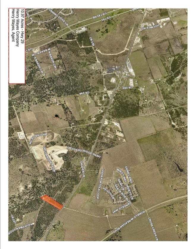
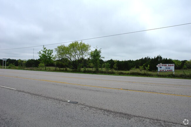
Property Record
29 W Highway, Leander, TX 78641

Property Detail
29 W Highway
Austin-Round Rock-San Marcos, TX
AW0453 MONROE, W.H. SUR., ACRES 1.91
R032264
WILLIAMSON
Agriculturalland
Texas
B and X Area of moderate flood hazard, usually the area between the limits of the 100-year and 500-year floods.
1.91 AC
2024
Georgetown
2025
Austin
020121
NEARBY LISTINGS FOR SALE OR LEASE
DEMOGRAPHICS near 29 W Highway
1 mile
3 mile
5 mile
2024 Total Population
4,904
39,054
81,909
2029 Population
5,948
47,211
97,954
Pop Growth 2024-2029
+ 21.29%
+ 20.89%
+ 19.59%
Average Age
34
36
37
2024 Total Households
1,594
13,309
28,641
HH Growth 2024-2029
+ 21.71%
+ 21.35%
+ 19.97%
Median Household Inc
$132,805
$134,308
$133,246
Avg Household Size
3.00
2.90
2.80
2024 Avg HH Vehicles
2.00
2.00
2.00
Median Home Value
$459,139
$479,061
$488,602
Median Year Built
2011
2011
2011
Nearby Places
Map Layers
Map Styles
 Street
 Aerial
Transit
 Traffic
 Biking
Places
Listings with unknown addresses are not visible on the map
- Restaurants
- Banks
- Shops
- Fitness
- Groceries
PUBLIC TRANSPORTATION
AIRPORT
Robert Gray AAF
Drive
Walk
Distance
Robert Gray AAF
62 min
38.1 mi
Freight Ports
Calhoun Port
Drive
Walk
Distance
Calhoun Port
224 min
185.4 mi
SALE & LEASE HISTORY
LISTING DATE
SALE/LEASE

Jul 28, 2017
For Sale
Jan 20, 2017
For Sale
Nearby Properties
Address
Land Use
TOTAL SIZE
Lot Size
Zoning
Address
Land Use
TOTAL SIZE
Lot Size
Zoning
454,000 SF
58.85 AC
Address
Land Use
TOTAL SIZE
Lot Size
Zoning
325,045 SF
11.40 AC
Address
Land Use
TOTAL SIZE
Lot Size
Zoning
312,374 SF
15.77 AC
Address
Land Use
TOTAL SIZE
Lot Size
Zoning
124,625 SF
14.41 AC
Address
Land Use
TOTAL SIZE
Lot Size
Zoning
232,172 SF
10.43 AC
Address
Land Use
TOTAL SIZE
Lot Size
Zoning
286,888 SF
20.68 AC
Address
Land Use
TOTAL SIZE
Lot Size
Zoning
247,584 SF
18.45 AC
Address
Land Use
TOTAL SIZE
Lot Size
Zoning
Address
Land Use
TOTAL SIZE
Lot Size
Zoning
1,971 SF
52.04 AC
Address
Land Use
TOTAL SIZE
Lot Size
Zoning
109,663 SF
19.54 AC
Address
Land Use
TOTAL SIZE
Lot Size
Zoning
11.98 AC
Address
Land Use
TOTAL SIZE
Lot Size
Zoning
256,008 SF
15.88 AC
Address
Land Use
TOTAL SIZE
Lot Size
Zoning
35,223 SF
9.75 AC
Address
Land Use
TOTAL SIZE
Lot Size
Zoning
37,809 SF
6.26 AC
Address
Land Use
TOTAL SIZE
Lot Size
Zoning
127,329 SF
32.79 AC
Address
Land Use
TOTAL SIZE
Lot Size
Zoning
159,400 SF
8.26 AC
Address
Land Use
TOTAL SIZE
Lot Size
Zoning
1,412 SF
20.17 AC
Address
Land Use
TOTAL SIZE
Lot Size
Zoning
46,979 SF
5.56 AC
Address
Land Use
TOTAL SIZE
Lot Size
Zoning
308,888 SF
34.18 AC
Address
Land Use
TOTAL SIZE
Lot Size
Zoning
67,651 SF
2.68 AC
Address
Land Use
TOTAL SIZE
Lot Size
Zoning
111,000 SF
15.27 AC
Address
Land Use
TOTAL SIZE
Lot Size
Zoning
72,209 SF
14.16 AC
Address
Land Use
TOTAL SIZE
Lot Size
Zoning
2,952 SF
131.47 AC
Address
Land Use
TOTAL SIZE
Lot Size
Zoning
101,012 SF
3.60 AC
Address
Land Use
TOTAL SIZE
Lot Size
Zoning
251.73 AC
Address
Land Use
TOTAL SIZE
Lot Size
Zoning
90,802 SF
10.36 AC
Address
Land Use
TOTAL SIZE
Lot Size
Zoning
27,212 SF
3.25 AC
Address
Land Use
TOTAL SIZE
Lot Size
Zoning
25,928 SF
15.13 AC
Address
Land Use
TOTAL SIZE
Lot Size
Zoning
66,034 SF
8.99 AC
Address
Land Use
TOTAL SIZE
Lot Size
Zoning
15.40 AC
The World's #1 Commercial Real Estate Marketplace
Connect with us
© 2026 CoStar Group
The information above has been obtained from sources believed reliable. While we do not doubt its accuracy we have not verified it and make no guarantee, warranty or representation about it. It is your responsibility to independently confirm its accuracy and completeness. Any projections, opinions, assumptions, or estimates used are for example only and do not represent the current or future performance of the property. The value of this transaction to you depends on tax and other factors which should be evaluated by your tax, financial, and legal advisors. You and your advisors should conduct a careful, independent investigation of the property to determine to your satisfaction the suitability of the property for your needs.