Property Record
290 Baker Ave, Concord, MA 01742


Save to a Folder
{{folder.Name}}
{{folder.ListingIds.length}} Properties
{{folder.ListingIds.length}} Property
Create a New Folder
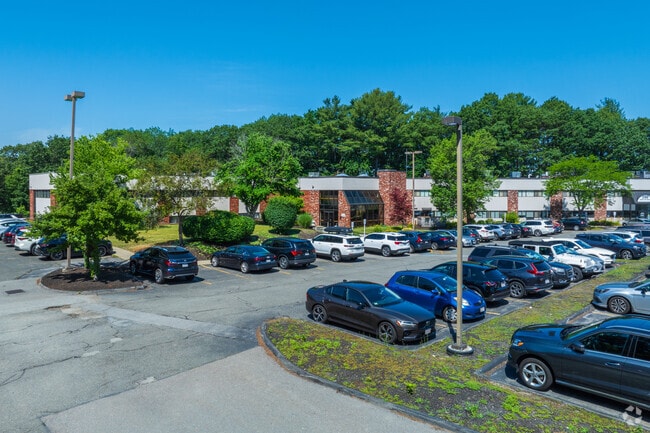
Property Detail
290 Baker Ave
CONC-000009E-003794-A000001
MIDDLESEX
Commercialcondominium
Massachusetts
IPA
a1
B and X Area of moderate flood hazard, usually the area between the limits of the 100-year and 500-year floods.
4.08 AC
2025
Concord/Maynard
2025
Boston
361100
Boston-Cambridge-Newton, MA-NH
126 SF
NEARBY LISTINGS FOR SALE OR LEASE
DEMOGRAPHICS near 290 Baker Ave
1 mile
3 mile
5 mile
2025 Total Population
5,668
26,665
71,752
2030 Population
5,980
27,883
74,965
Pop Growth 2025-2030
+ 5.50%
+ 4.57%
+ 4.48%
Average Age
47
44
43
2025 Total Households
2,326
10,084
27,124
HH Growth 2025-2030
+ 5.80%
+ 4.78%
+ 4.64%
Median Household Inc
$188,879
$192,101
$175,156
Avg Household Size
2.30
2.50
2.60
2025 Avg HH Vehicles
2.00
2.00
2.00
Median Home Value
$953,618
$1,001,617
$874,664
Median Year Built
1973
1971
1973
Nearby Places
Map Layers
Map Styles
 Street
 Aerial
Layers
 Traffic
 Biking
Places
Listings with unknown addresses are not visible on the map
- Restaurants
- Banks
- Shops
- Fitness
- Groceries
PUBLIC TRANSPORTATION
COMMUTER RAIL
West Concord (Fitchburg/South Acton Line - Massachusetts Bay Transportation Authority Commuter Rail (Purple Line))
Drive
Walk
Distance
West Concord (Fitchburg/South Acton Line - Massachusetts Bay Transportation Authority Commuter Rail (Purple Line))
2 min
13 min
0.7 mi
Concord (Fitchburg/South Acton Line - Massachusetts Bay Transportation Authority Commuter Rail (Purple Line))
Drive
Walk
Distance
Concord (Fitchburg/South Acton Line - Massachusetts Bay Transportation Authority Commuter Rail (Purple Line))
5 min
2.3 mi
AIRPORT
General Edward Lawrence Logan International
Drive
Walk
Distance
General Edward Lawrence Logan International
38 min
23.9 mi
Worcester Regional
Drive
Walk
Distance
Worcester Regional
54 min
37.1 mi
Freight Ports
Port of Boston
Drive
Walk
Distance
Port of Boston
38 min
24.0 mi
SALE & LEASE HISTORY
LISTING DATE
SALE/LEASE

Sep 25, 2016
For Lease
Sep 15, 2017
For Sale
Mar 22, 2021
For Lease
Jul 15, 2021
For Sale
Jul 15, 2021
For Sale
Jan 02, 2018
For Sale
Feb 05, 2024
For Lease
Aug 17, 2022
For Sale
Aug 05, 2017
For Sale
Nearby Properties
Address
Land Use
TOTAL SIZE
Lot Size
Zoning
Address
Land Use
TOTAL SIZE
Lot Size
Zoning
30.39 AC
I
Address
Land Use
TOTAL SIZE
Lot Size
Zoning
2,080 SF
289.85 AC
AA
Address
Land Use
TOTAL SIZE
Lot Size
Zoning
417,293 SF
64.97 AC
I
Address
Land Use
TOTAL SIZE
Lot Size
Zoning
24,540 SF
24.99 AC
B
Address
Land Use
TOTAL SIZE
Lot Size
Zoning
93.60 AC
A
Address
Land Use
TOTAL SIZE
Lot Size
Zoning
130,529 SF
18.90 AC
A
Address
Land Use
TOTAL SIZE
Lot Size
Zoning
22,927 SF
51 AC
IPA
Address
Land Use
TOTAL SIZE
Lot Size
Zoning
18.78 AC
MP
Address
Land Use
TOTAL SIZE
Lot Size
Zoning
116,968 SF
3.44 AC
WCI
Address
Land Use
TOTAL SIZE
Lot Size
Zoning
77,323 SF
18 AC
C
Address
Land Use
TOTAL SIZE
Lot Size
Zoning
79,616 SF
27.03 AC
A
Address
Land Use
TOTAL SIZE
Lot Size
Zoning
31.29 AC
AA
Address
Land Use
TOTAL SIZE
Lot Size
Zoning
7.88 AC
B
Address
Land Use
TOTAL SIZE
Lot Size
Zoning
67,788 SF
5.61 AC
RD
Address
Land Use
TOTAL SIZE
Lot Size
Zoning
9.56 AC
PM
Address
Land Use
TOTAL SIZE
Lot Size
Zoning
10.34 AC
LB
Address
Land Use
TOTAL SIZE
Lot Size
Zoning
54,892 SF
7.99 AC
AA
Address
Land Use
TOTAL SIZE
Lot Size
Zoning
75,917 SF
28.56 AC
AA
Address
Land Use
TOTAL SIZE
Lot Size
Zoning
50,355 SF
6.38 AC
IPA
Address
Land Use
TOTAL SIZE
Lot Size
Zoning
13.07 AC
RD
Address
Land Use
TOTAL SIZE
Lot Size
Zoning
4,621 SF
64.80 AC
RD
Address
Land Use
TOTAL SIZE
Lot Size
Zoning
53,684 SF
3 AC
C
Address
Land Use
TOTAL SIZE
Lot Size
Zoning
9.61 AC
I
Address
Land Use
TOTAL SIZE
Lot Size
Zoning
13.30 AC
AA
Address
Land Use
TOTAL SIZE
Lot Size
Zoning
63.75 AC
A
Address
Land Use
TOTAL SIZE
Lot Size
Zoning
37,309 SF
1.71 AC
B
Address
Land Use
TOTAL SIZE
Lot Size
Zoning
138.34 AC
A
Address
Land Use
TOTAL SIZE
Lot Size
Zoning
75,182 SF
6.74 AC
IPA
Address
Land Use
TOTAL SIZE
Lot Size
Zoning
170 AC
B
Address
Land Use
TOTAL SIZE
Lot Size
Zoning
78,564 SF
3.43 AC
LB
The World's #1 Commercial Real Estate Marketplace
Connect with us
© 2026 CoStar Group
The information above has been obtained from sources believed reliable. While we do not doubt its accuracy we have not verified it and make no guarantee, warranty or representation about it. It is your responsibility to independently confirm its accuracy and completeness. Any projections, opinions, assumptions, or estimates used are for example only and do not represent the current or future performance of the property. The value of this transaction to you depends on tax and other factors which should be evaluated by your tax, financial, and legal advisors. You and your advisors should conduct a careful, independent investigation of the property to determine to your satisfaction the suitability of the property for your needs.