Property Record
290 Disc Dr, Sparks, NV 89436


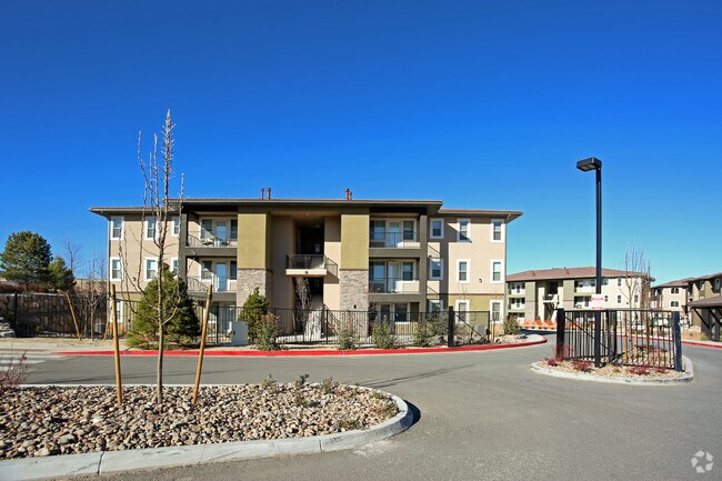
Property Detail
290 Disc Dr
510-482-08
PM 4789 LT 1B-R
Multifamilydwelling
Washoe
NUD
Nevada
B and X Area of moderate flood hazard, usually the area between the limits of the 100-year and 500-year floods.
1b
2025
10.94 AC
2026
Outer Sparks
003508
Reno/Sparks
279,596 SF
Reno, NV
NEARBY LISTINGS FOR SALE OR LEASE
DEMOGRAPHICS near 290 Disc Dr
1 mile
3 mile
5 mile
2025 Total Population
6,411
107,649
187,086
2030 Population
6,547
110,306
192,624
Pop Growth 2025-2030
+ 2.12%
+ 2.47%
+ 2.96%
Average Age
41
39
39
2025 Total Households
2,393
40,335
69,371
HH Growth 2025-2030
+ 2.26%
+ 2.67%
+ 3.10%
Median Household Inc
$96,485
$83,063
$76,859
Avg Household Size
2.70
2.60
2.60
2025 Avg HH Vehicles
2.00
2.00
2.00
Median Home Value
$507,889
$444,554
$458,136
Median Year Built
2001
1989
1992
Nearby Places
Map Layers
Map Styles
 Street
 Aerial
Layers
 Traffic
 Biking
Places
Listings with unknown addresses are not visible on the map
- Restaurants
- Banks
- Shops
- Fitness
- Groceries
PUBLIC TRANSPORTATION
COMMUTER RAIL
Reno (California Zephyr - Amtrak)
Drive
Walk
Distance
Reno (California Zephyr - Amtrak)
13 min
7.4 mi
AIRPORT
Reno/Tahoe International
Drive
Walk
Distance
Reno/Tahoe International
31 min
11.1 mi
Freight Ports
Port of Stockton
Drive
Walk
Distance
Port of Stockton
217 min
185.5 mi
Nearby Properties
Address
Land Use
TOTAL SIZE
Lot Size
Zoning
Address
Land Use
TOTAL SIZE
Lot Size
Zoning
294,872 SF
69.02 AC
PF
Address
Land Use
TOTAL SIZE
Lot Size
Zoning
406,338 SF
15.07 AC
NUD
Address
Land Use
TOTAL SIZE
Lot Size
Zoning
416,482 SF
21.84 AC
PD
Address
Land Use
TOTAL SIZE
Lot Size
Zoning
333,867 SF
14.71 AC
NUD
Address
Land Use
TOTAL SIZE
Lot Size
Zoning
271,111 SF
31.84 AC
NUD
Address
Land Use
TOTAL SIZE
Lot Size
Zoning
356,160 SF
12.05 AC
MUD
Address
Land Use
TOTAL SIZE
Lot Size
Zoning
347,564 SF
10.23 AC
MUD
Address
Land Use
TOTAL SIZE
Lot Size
Zoning
321,941 SF
36 AC
NUD
Address
Land Use
TOTAL SIZE
Lot Size
Zoning
365,962 SF
3.54 AC
PD
Address
Land Use
TOTAL SIZE
Lot Size
Zoning
246,076 SF
16.43 AC
PD
Address
Land Use
TOTAL SIZE
Lot Size
Zoning
232,481 SF
9.45 AC
PD
Address
Land Use
TOTAL SIZE
Lot Size
Zoning
248,124 SF
19.35 AC
PD
Address
Land Use
TOTAL SIZE
Lot Size
Zoning
273,101 SF
15.96 AC
MF-3/PUD
Address
Land Use
TOTAL SIZE
Lot Size
Zoning
237,680 SF
16.65 AC
PD
Address
Land Use
TOTAL SIZE
Lot Size
Zoning
258,793 SF
14.86 AC
MF-3
Address
Land Use
TOTAL SIZE
Lot Size
Zoning
173,178 SF
8.15 AC
MUD
Address
Land Use
TOTAL SIZE
Lot Size
Zoning
396,497 SF
20.80 AC
PD
Address
Land Use
TOTAL SIZE
Lot Size
Zoning
203,303 SF
20.97 AC
C2
Address
Land Use
TOTAL SIZE
Lot Size
Zoning
146,255 SF
9.99 AC
MDU
Address
Land Use
TOTAL SIZE
Lot Size
Zoning
221,512 SF
15.32 AC
MUD
Address
Land Use
TOTAL SIZE
Lot Size
Zoning
197,364 SF
11.34 AC
NUD
Address
Land Use
TOTAL SIZE
Lot Size
Zoning
186,572 SF
12.17 AC
NUD
Address
Land Use
TOTAL SIZE
Lot Size
Zoning
74,637 SF
6.04 AC
NUD
Address
Land Use
TOTAL SIZE
Lot Size
Zoning
148,346 SF
15.79 AC
NUD
Address
Land Use
TOTAL SIZE
Lot Size
Zoning
187,768 SF
12.02 AC
MUD
Address
Land Use
TOTAL SIZE
Lot Size
Zoning
104,418 SF
6.02 AC
GC
Address
Land Use
TOTAL SIZE
Lot Size
Zoning
70,030 SF
36.71 AC
PSP
Address
Land Use
TOTAL SIZE
Lot Size
Zoning
269,970 SF
54 AC
PF
Address
Land Use
TOTAL SIZE
Lot Size
Zoning
11,740 SF
13.40 AC
NUD
The World's #1 Commercial Real Estate Marketplace
Connect with us
© 2026 CoStar Group
The information above has been obtained from sources believed reliable. While we do not doubt its accuracy we have not verified it and make no guarantee, warranty or representation about it. It is your responsibility to independently confirm its accuracy and completeness. Any projections, opinions, assumptions, or estimates used are for example only and do not represent the current or future performance of the property. The value of this transaction to you depends on tax and other factors which should be evaluated by your tax, financial, and legal advisors. You and your advisors should conduct a careful, independent investigation of the property to determine to your satisfaction the suitability of the property for your needs.