Property Record
290 E Rd Rd, , OK

Save to a Folder
{{folder.Name}}
{{folder.ListingIds.length}} Properties
{{folder.ListingIds.length}} Property
Create a New Folder
Current Lease Availabilities
Property Detail
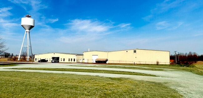
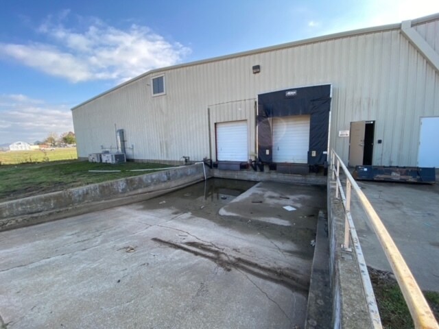
290 E Rd Rd
0000453
33-25-24 PT SE DESCRIBED AS: BEG AT INTERSECTION OF N BNDRY OF ST HWY 10 W/W BNDRY OF CO RD ALONG E SIDE IN SE COR OF SEC FOR
Manufacturinglight
DELAWARE
2025
Oklahoma
2025
19.93 AC
000375
Oklahoma East Area
88,720 SF
Other Market Areas
NEARBY LISTINGS FOR SALE OR LEASE
DEMOGRAPHICS near 290 E Rd Rd
1 mile
3 mile
5 mile
2025 Total Population
241
4,283
13,707
2030 Population
241
4,306
14,125
Pop Growth 2025-2030
0.00%
+ 0.54%
+ 3.05%
Average Age
39
43
46
2025 Total Households
92
1,803
5,950
HH Growth 2025-2030
(1.09%)
+ 0.17%
+ 2.82%
Median Household Inc
$62,250
$52,685
$54,474
Avg Household Size
2.50
2.30
2.20
2025 Avg HH Vehicles
2.00
2.00
2.00
Median Home Value
$259,999
$244,557
$228,333
Median Year Built
1994
1987
1988
Nearby Places
Map Layers
Map Styles
 Street
 Aerial
Layers
 Traffic
 Biking
Places
Listings with unknown addresses are not visible on the map
- Restaurants
- Banks
- Shops
- Fitness
- Groceries
Nearby Properties
Address
Land Use
TOTAL SIZE
Lot Size
Zoning
Address
Land Use
TOTAL SIZE
Lot Size
Zoning
8,280 SF
1 AC
Address
Land Use
TOTAL SIZE
Lot Size
Zoning
33,164 SF
9.06 AC
Address
Land Use
TOTAL SIZE
Lot Size
Zoning
1,125 SF
4.16 AC
Address
Land Use
TOTAL SIZE
Lot Size
Zoning
3,960 SF
4 AC
Address
Land Use
TOTAL SIZE
Lot Size
Zoning
62,200 SF
4.86 AC
Address
Land Use
TOTAL SIZE
Lot Size
Zoning
30,600 SF
2.75 AC
Address
Land Use
TOTAL SIZE
Lot Size
Zoning
4,774 SF
1.33 AC
Address
Land Use
TOTAL SIZE
Lot Size
Zoning
14,742 SF
1.74 AC
Address
Land Use
TOTAL SIZE
Lot Size
Zoning
575 SF
3 AC
Address
Land Use
TOTAL SIZE
Lot Size
Zoning
5,436 SF
0.30 AC
Address
Land Use
TOTAL SIZE
Lot Size
Zoning
31,691 SF
3.90 AC
Address
Land Use
TOTAL SIZE
Lot Size
Zoning
10,121 SF
2.32 AC
Address
Land Use
TOTAL SIZE
Lot Size
Zoning
12,540 SF
1.77 AC
Address
Land Use
TOTAL SIZE
Lot Size
Zoning
11,348 SF
1 AC
Address
Land Use
TOTAL SIZE
Lot Size
Zoning
1,254 SF
14.10 AC
Address
Land Use
TOTAL SIZE
Lot Size
Zoning
5,639 SF
Address
Land Use
TOTAL SIZE
Lot Size
Zoning
3,113 SF
1.23 AC
Address
Land Use
TOTAL SIZE
Lot Size
Zoning
Address
Land Use
TOTAL SIZE
Lot Size
Zoning
9,800 SF
1.58 AC
Address
Land Use
TOTAL SIZE
Lot Size
Zoning
10,773 SF
1.43 AC
Address
Land Use
TOTAL SIZE
Lot Size
Zoning
2,400 SF
12.04 AC
Address
Land Use
TOTAL SIZE
Lot Size
Zoning
54,475 SF
2 AC
The World's #1 Commercial Real Estate Marketplace
Connect with us
© 2026 CoStar Group
The information above has been obtained from sources believed reliable. While we do not doubt its accuracy we have not verified it and make no guarantee, warranty or representation about it. It is your responsibility to independently confirm its accuracy and completeness. Any projections, opinions, assumptions, or estimates used are for example only and do not represent the current or future performance of the property. The value of this transaction to you depends on tax and other factors which should be evaluated by your tax, financial, and legal advisors. You and your advisors should conduct a careful, independent investigation of the property to determine to your satisfaction the suitability of the property for your needs.