Property Record
290 E Strand St, Kingston, NY 12401


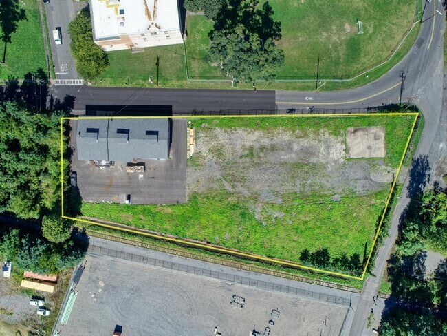

Property Detail
290 E Strand St
0800-056.036-0001-016.000-0000
Ulster
Storageyardjunkautowreckingsalvage
New York
SD
16.000
AE The base floodplain where base flood elevations are provided. AE Zones are now used on new format FIRMs instead of A1-A30 Zones.
0.59 AC
2025
Kingston Waterfront
2025
Other Market Areas
951700
Kingston, NY
4,982 SF
NEARBY LISTINGS FOR SALE OR LEASE
DEMOGRAPHICS near 290 E Strand St
1 mile
3 mile
5 mile
2025 Total Population
4,097
29,789
48,172
2030 Population
3,987
29,227
47,596
Pop Growth 2025-2030
(2.68%)
(1.89%)
(1.20%)
Average Age
41
44
44
2025 Total Households
1,853
12,852
20,412
HH Growth 2025-2030
(2.75%)
(1.93%)
(1.24%)
Median Household Inc
$71,594
$74,649
$80,045
Avg Household Size
2.10
2.10
2.20
2025 Avg HH Vehicles
1.00
2.00
2.00
Median Home Value
$281,097
$324,418
$347,553
Median Year Built
1948
1951
1957
Nearby Places
Map Layers
Map Styles
 Street
 Aerial
Layers
 Traffic
 Biking
Places
Listings with unknown addresses are not visible on the map
- Restaurants
- Banks
- Shops
- Fitness
- Groceries
PUBLIC TRANSPORTATION
AIRPORT
New York Stewart International
Drive
Walk
Distance
New York Stewart International
54 min
37.5 mi
SALE & LEASE HISTORY
LISTING DATE
SALE/LEASE

Oct 20, 2022
For Sale
Aug 09, 2022
For Lease
Nearby Properties
Address
Land Use
TOTAL SIZE
Lot Size
Zoning
Address
Land Use
TOTAL SIZE
Lot Size
Zoning
820,644 SF
36.70 AC
HP20
Address
Land Use
TOTAL SIZE
Lot Size
Zoning
21.40 AC
R-1
Address
Land Use
TOTAL SIZE
Lot Size
Zoning
1.58 AC
T5F
Address
Land Use
TOTAL SIZE
Lot Size
Zoning
240,924 SF
17 AC
SD
Address
Land Use
TOTAL SIZE
Lot Size
Zoning
97,993 SF
18.40 AC
RA35
Address
Land Use
TOTAL SIZE
Lot Size
Zoning
181,151 SF
4.90 AC
SD
Address
Land Use
TOTAL SIZE
Lot Size
Zoning
41,767 SF
6.91 AC
R35
Address
Land Use
TOTAL SIZE
Lot Size
Zoning
250,613 SF
11.70 AC
SD
Address
Land Use
TOTAL SIZE
Lot Size
Zoning
68,465 SF
2.80 AC
R35
Address
Land Use
TOTAL SIZE
Lot Size
Zoning
71,781 SF
6.50 AC
R40
Address
Land Use
TOTAL SIZE
Lot Size
Zoning
24,321 SF
46.40 AC
T2C
Address
Land Use
TOTAL SIZE
Lot Size
Zoning
109,860 SF
8.60 AC
35
Address
Land Use
TOTAL SIZE
Lot Size
Zoning
28,633 SF
18.97 AC
R35
Address
Land Use
TOTAL SIZE
Lot Size
Zoning
172.24 AC
HP20
Address
Land Use
TOTAL SIZE
Lot Size
Zoning
76,788 SF
0.77 AC
T5N
Address
Land Use
TOTAL SIZE
Lot Size
Zoning
143,271 SF
20.40 AC
SD
Address
Land Use
TOTAL SIZE
Lot Size
Zoning
16,933 SF
14.90 AC
SD
Address
Land Use
TOTAL SIZE
Lot Size
Zoning
900 SF
1.40 AC
R1A
Address
Land Use
TOTAL SIZE
Lot Size
Zoning
67,180 SF
2.60 AC
T5MS
Address
Land Use
TOTAL SIZE
Lot Size
Zoning
97,636 SF
2.60 AC
T5MS
Address
Land Use
TOTAL SIZE
Lot Size
Zoning
53,605 SF
10.83 AC
T5N
Address
Land Use
TOTAL SIZE
Lot Size
Zoning
88,000 SF
6.90 AC
GC
Address
Land Use
TOTAL SIZE
Lot Size
Zoning
10,581 SF
37.69 AC
HP20
Address
Land Use
TOTAL SIZE
Lot Size
Zoning
8,674 SF
10.90 AC
SD
Address
Land Use
TOTAL SIZE
Lot Size
Zoning
67,566 SF
2.90 AC
T5N
Address
Land Use
TOTAL SIZE
Lot Size
Zoning
20.10 AC
SD
Address
Land Use
TOTAL SIZE
Lot Size
Zoning
76,577 SF
1.30 AC
T5F
Address
Land Use
TOTAL SIZE
Lot Size
Zoning
4,104 SF
14.38 AC
SD
Address
Land Use
TOTAL SIZE
Lot Size
Zoning
2,670 SF
20.90 AC
SD
Address
Land Use
TOTAL SIZE
Lot Size
Zoning
11,488 SF
10.80 AC
SD
The World's #1 Commercial Real Estate Marketplace
Connect with us
© 2026 CoStar Group
The information above has been obtained from sources believed reliable. While we do not doubt its accuracy we have not verified it and make no guarantee, warranty or representation about it. It is your responsibility to independently confirm its accuracy and completeness. Any projections, opinions, assumptions, or estimates used are for example only and do not represent the current or future performance of the property. The value of this transaction to you depends on tax and other factors which should be evaluated by your tax, financial, and legal advisors. You and your advisors should conduct a careful, independent investigation of the property to determine to your satisfaction the suitability of the property for your needs.