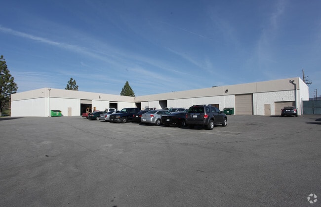
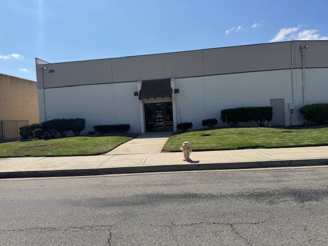
Property Record
290 E Easy St, Simi Valley, CA 93065

Current Lease Availabilities
Property Detail
290 E Easy St
630-0-113-035
LOT: 3 REF: 007PM 003
Industrialgeneral
Ventura
GI
California
AO River or stream flood hazard areas, and areas with a 1% or greater chance of shallow flooding each year. These areas have a 26% chance of flooding over the life of a 30-year mortgage.
3
2024
1.09 AC
2025
Moorpark/Simi Val
007700
Los Angeles
19,050 SF
Oxnard-Thousand Oaks-Ventura, CA
NEARBY LISTINGS FOR SALE OR LEASE
DEMOGRAPHICS near 290 E Easy St
1 mile
3 mile
5 mile
2025 Total Population
8,905
60,930
123,883
2030 Population
8,804
60,296
122,805
Pop Growth 2025-2030
(1.13%)
(1.04%)
(0.87%)
Average Age
40
41
42
2025 Total Households
3,084
20,183
41,038
HH Growth 2025-2030
(1.30%)
(1.27%)
(1.06%)
Median Household Inc
$110,775
$111,656
$128,545
Avg Household Size
2.80
2.90
2.90
2025 Avg HH Vehicles
2.00
2.00
2.00
Median Home Value
$738,917
$788,334
$830,977
Median Year Built
1984
1980
1981
Nearby Places
Map Layers
Map Styles
 Street
 Aerial
Transit
 Traffic
 Biking
Places
Listings with unknown addresses are not visible on the map
- Restaurants
- Banks
- Shops
- Fitness
- Groceries
PUBLIC TRANSPORTATION
COMMUTER RAIL
Simi Valley (Ventura County Line - Southern California Regional Rail Authority (Metrolink))
Drive
Walk
Distance
Simi Valley (Ventura County Line - Southern California Regional Rail Authority (Metrolink))
11 min
5.9 mi
Moorpark (Ventura County Line - Southern California Regional Rail Authority (Metrolink))
Drive
Walk
Distance
Moorpark (Ventura County Line - Southern California Regional Rail Authority (Metrolink))
12 min
7.4 mi
AIRPORT
Bob Hope
Drive
Walk
Distance
Bob Hope
37 min
29.0 mi
Los Angeles International
Drive
Walk
Distance
Los Angeles International
57 min
44.9 mi
Nearby Properties
Address
Land Use
TOTAL SIZE
Lot Size
Zoning
Address
Land Use
TOTAL SIZE
Lot Size
Zoning
4.77 AC
CO
Address
Land Use
TOTAL SIZE
Lot Size
Zoning
99.98 AC
OS40AC
Address
Land Use
TOTAL SIZE
Lot Size
Zoning
286,132 SF
15.07 AC
RVH-.
Address
Land Use
TOTAL SIZE
Lot Size
Zoning
28,561 SF
43.55 AC
BP-S
Address
Land Use
TOTAL SIZE
Lot Size
Zoning
45,594 SF
15.99 AC
RVH-2
Address
Land Use
TOTAL SIZE
Lot Size
Zoning
265,102 SF
12.30 AC
Address
Land Use
TOTAL SIZE
Lot Size
Zoning
238,578 SF
10.85 AC
Address
Land Use
TOTAL SIZE
Lot Size
Zoning
27,916 SF
8.06 AC
RVH-.
Address
Land Use
TOTAL SIZE
Lot Size
Zoning
276,943 SF
24.62 AC
RVH-
Address
Land Use
TOTAL SIZE
Lot Size
Zoning
71,166 SF
12.44 AC
GI
Address
Land Use
TOTAL SIZE
Lot Size
Zoning
99,340 SF
5.96 AC
RVH-0
Address
Land Use
TOTAL SIZE
Lot Size
Zoning
21,873 SF
17.04 AC
Address
Land Use
TOTAL SIZE
Lot Size
Zoning
14.66 AC
Address
Land Use
TOTAL SIZE
Lot Size
Zoning
75,104 SF
4.95 AC
RVH-.
Address
Land Use
TOTAL SIZE
Lot Size
Zoning
18,820 SF
11.46 AC
Address
Land Use
TOTAL SIZE
Lot Size
Zoning
89,902 SF
4.03 AC
Address
Land Use
TOTAL SIZE
Lot Size
Zoning
14,120 SF
8.22 AC
Address
Land Use
TOTAL SIZE
Lot Size
Zoning
20,660 SF
8.15 AC
Address
Land Use
TOTAL SIZE
Lot Size
Zoning
66,724 SF
2.83 AC
Address
Land Use
TOTAL SIZE
Lot Size
Zoning
18,889 SF
10.29 AC
A1
Address
Land Use
TOTAL SIZE
Lot Size
Zoning
Address
Land Use
TOTAL SIZE
Lot Size
Zoning
10,368 SF
13.36 AC
Address
Land Use
TOTAL SIZE
Lot Size
Zoning
3.27 AC
CPD
Address
Land Use
TOTAL SIZE
Lot Size
Zoning
71,396 SF
12.11 AC
GI
Address
Land Use
TOTAL SIZE
Lot Size
Zoning
78,222 SF
5.45 AC
Address
Land Use
TOTAL SIZE
Lot Size
Zoning
2.12 AC
Address
Land Use
TOTAL SIZE
Lot Size
Zoning
Address
Land Use
TOTAL SIZE
Lot Size
Zoning
2.24 AC
The World's #1 Commercial Real Estate Marketplace
Connect with us
© 2026 CoStar Group
The information above has been obtained from sources believed reliable. While we do not doubt its accuracy we have not verified it and make no guarantee, warranty or representation about it. It is your responsibility to independently confirm its accuracy and completeness. Any projections, opinions, assumptions, or estimates used are for example only and do not represent the current or future performance of the property. The value of this transaction to you depends on tax and other factors which should be evaluated by your tax, financial, and legal advisors. You and your advisors should conduct a careful, independent investigation of the property to determine to your satisfaction the suitability of the property for your needs.