No Photo
Property Record
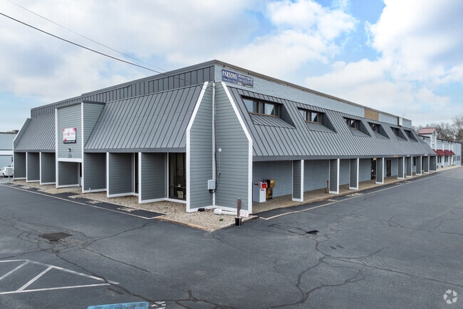
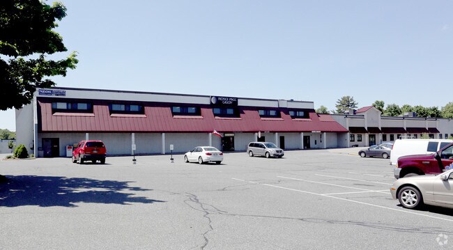
290 Eliot St, Ashland, MA 01721


Property Detail
290 Eliot St
Storebuilding
Middlesex
30
Massachusetts
B and X Area of moderate flood hazard, usually the area between the limits of the 100-year and 500-year floods.
3.02 AC
2025
Hopkinton/Holliston
2025
Boston
385203
Boston-Cambridge-Newton, MA-NH
50,000 SF
ASHL-000025-000319
NEARBY LISTINGS FOR SALE OR LEASE
DEMOGRAPHICS near 290 Eliot St
1 mile
3 mile
5 mile
2025 Total Population
6,822
49,746
124,892
2030 Population
7,101
52,064
130,603
Pop Growth 2025-2030
+ 4.09%
+ 4.66%
+ 4.57%
Average Age
43
40
40
2025 Total Households
2,734
18,083
47,079
HH Growth 2025-2030
+ 4.13%
+ 4.81%
+ 4.67%
Median Household Inc
$123,789
$108,795
$118,190
Avg Household Size
2.40
2.60
2.50
2025 Avg HH Vehicles
2.00
2.00
2.00
Median Home Value
$593,611
$685,068
$717,350
Median Year Built
1983
1970
1972
Nearby Places
Map Layers
Map Styles
 Street
 Aerial
Transit
 Traffic
 Biking
Places
Listings with unknown addresses are not visible on the map
- Restaurants
- Banks
- Shops
- Fitness
- Groceries
PUBLIC TRANSPORTATION
COMMUTER RAIL
Drive
Walk
Distance
6 min
2.8 mi
Framingham (Framingham/Worcester Line - Massachusetts Bay Transportation Authority Commuter Rail (Purple Line))
Drive
Walk
Distance
Framingham (Framingham/Worcester Line - Massachusetts Bay Transportation Authority Commuter Rail (Purple Line))
6 min
2.8 mi
AIRPORT
Worcester Regional
Drive
Walk
Distance
Worcester Regional
48 min
26.7 mi
General Edward Lawrence Logan International
Drive
Walk
Distance
General Edward Lawrence Logan International
44 min
27.6 mi
SALE & LEASE HISTORY
LISTING DATE
SALE/LEASE

Sep 04, 2019
For Lease
Dec 07, 2023
For Lease
Nearby Properties
Address
Land Use
TOTAL SIZE
Lot Size
Zoning
Address
Land Use
TOTAL SIZE
Lot Size
Zoning
556,849 SF
28.44 AC
R4
Address
Land Use
TOTAL SIZE
Lot Size
Zoning
315,055 SF
40.38 AC
G
Address
Land Use
TOTAL SIZE
Lot Size
Zoning
244,033 SF
25.75 AC
R1
Address
Land Use
TOTAL SIZE
Lot Size
Zoning
108.84 AC
M
Address
Land Use
TOTAL SIZE
Lot Size
Zoning
372,275 SF
3.05 AC
CB
Address
Land Use
TOTAL SIZE
Lot Size
Zoning
139,356 SF
52 AC
30
Address
Land Use
TOTAL SIZE
Lot Size
Zoning
251,366 SF
14.42 AC
G
Address
Land Use
TOTAL SIZE
Lot Size
Zoning
3.02 AC
CB
Address
Land Use
TOTAL SIZE
Lot Size
Zoning
112,000 SF
18.48 AC
R1
Address
Land Use
TOTAL SIZE
Lot Size
Zoning
150,636 SF
30.34 AC
GE
Address
Land Use
TOTAL SIZE
Lot Size
Zoning
140,695 SF
2.52 AC
G
Address
Land Use
TOTAL SIZE
Lot Size
Zoning
154,724 SF
39.70 AC
R3
Address
Land Use
TOTAL SIZE
Lot Size
Zoning
39,840 SF
17.20 AC
G
Address
Land Use
TOTAL SIZE
Lot Size
Zoning
61,866 SF
9.40 AC
G
Address
Land Use
TOTAL SIZE
Lot Size
Zoning
117,332 SF
3.02 AC
CB
Address
Land Use
TOTAL SIZE
Lot Size
Zoning
42,000 SF
3.82 AC
30
Address
Land Use
TOTAL SIZE
Lot Size
Zoning
70,457 SF
0.26 AC
CB
Address
Land Use
TOTAL SIZE
Lot Size
Zoning
75,224 SF
4.05 AC
I
Address
Land Use
TOTAL SIZE
Lot Size
Zoning
90,256 SF
14.48 AC
R4
Address
Land Use
TOTAL SIZE
Lot Size
Zoning
226,884 SF
6.16 AC
WMUSD
Address
Land Use
TOTAL SIZE
Lot Size
Zoning
67,708 SF
6.09 AC
M
Address
Land Use
TOTAL SIZE
Lot Size
Zoning
169,461 SF
32.30 AC
40
Address
Land Use
TOTAL SIZE
Lot Size
Zoning
71,070 SF
1.66 AC
R4
Address
Land Use
TOTAL SIZE
Lot Size
Zoning
85,380 SF
15.02 AC
R4
Address
Land Use
TOTAL SIZE
Lot Size
Zoning
237,660 SF
20.98 AC
I
Address
Land Use
TOTAL SIZE
Lot Size
Zoning
71,500 SF
3.40 AC
30
Address
Land Use
TOTAL SIZE
Lot Size
Zoning
134.63 AC
A
Address
Land Use
TOTAL SIZE
Lot Size
Zoning
40,000 SF
26.63 AC
30
Address
Land Use
TOTAL SIZE
Lot Size
Zoning
58,053 SF
22.07 AC
R4
Address
Land Use
TOTAL SIZE
Lot Size
Zoning
103,138 SF
1.95 AC
CB
The World's #1 Commercial Real Estate Marketplace
Connect with us
© 2026 CoStar Group
The information above has been obtained from sources believed reliable. While we do not doubt its accuracy we have not verified it and make no guarantee, warranty or representation about it. It is your responsibility to independently confirm its accuracy and completeness. Any projections, opinions, assumptions, or estimates used are for example only and do not represent the current or future performance of the property. The value of this transaction to you depends on tax and other factors which should be evaluated by your tax, financial, and legal advisors. You and your advisors should conduct a careful, independent investigation of the property to determine to your satisfaction the suitability of the property for your needs.