Property Record
290 Enterprise Dr, Easley, SC 29642


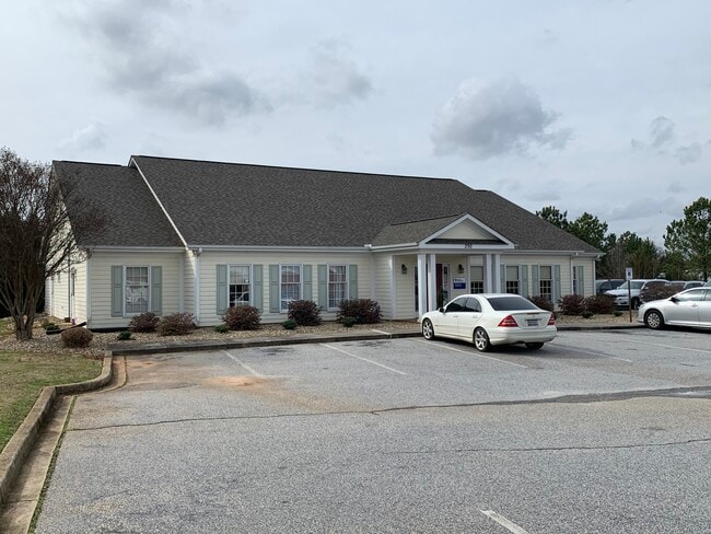
Property Detail
290 Enterprise Dr
236-07-01-043
CP S 1277/1 + 2 PP 1242/3 F000 D000 PP 115/0813 ENTERPRISES DR 1.99 AC
Officebuilding
Anderson
B and X Area of moderate flood hazard, usually the area between the limits of the 100-year and 500-year floods.
South Carolina
2025
1.99 AC
2025
Powdersville/Easley
010103
Greenville/Spartanburg
6,220 SF
Greenville-Anderson-Greer, SC
NEARBY LISTINGS FOR SALE OR LEASE
DEMOGRAPHICS near 290 Enterprise Dr
1 mile
3 mile
5 mile
2025 Total Population
3,818
22,855
67,339
2030 Population
4,030
24,155
71,543
Pop Growth 2025-2030
+ 5.55%
+ 5.69%
+ 6.24%
Average Age
39
39
40
2025 Total Households
1,466
8,488
25,704
HH Growth 2025-2030
+ 5.87%
+ 5.96%
+ 6.47%
Median Household Inc
$71,962
$75,651
$65,625
Avg Household Size
2.60
2.70
2.60
2025 Avg HH Vehicles
2.00
2.00
2.00
Median Home Value
$372,988
$298,664
$262,818
Median Year Built
1998
1993
1989
Nearby Places
Map Layers
Map Styles
 Street
 Aerial
Transit
 Traffic
 Biking
Places
Listings with unknown addresses are not visible on the map
- Restaurants
- Banks
- Shops
- Fitness
- Groceries
PUBLIC TRANSPORTATION
COMMUTER RAIL
Drive
Walk
Distance
17 min
7.6 mi
AIRPORT
Greenville Spartanburg International
Drive
Walk
Distance
Greenville Spartanburg International
29 min
20.5 mi
SALE & LEASE HISTORY
LISTING DATE
SALE/LEASE

May 17, 2022
For Sale
Feb 27, 2020
For Lease
Nearby Properties
Address
Land Use
TOTAL SIZE
Lot Size
Zoning
Address
Land Use
TOTAL SIZE
Lot Size
Zoning
14 AC
S1
Address
Land Use
TOTAL SIZE
Lot Size
Zoning
14,544 SF
22.61 AC
Address
Land Use
TOTAL SIZE
Lot Size
Zoning
18,334 SF
6.27 AC
Address
Land Use
TOTAL SIZE
Lot Size
Zoning
68,402 SF
4.32 AC
Address
Land Use
TOTAL SIZE
Lot Size
Zoning
65.30 AC
RS
Address
Land Use
TOTAL SIZE
Lot Size
Zoning
4,778 SF
10.45 AC
Address
Land Use
TOTAL SIZE
Lot Size
Zoning
683 SF
16.53 AC
Address
Land Use
TOTAL SIZE
Lot Size
Zoning
13.99 AC
Address
Land Use
TOTAL SIZE
Lot Size
Zoning
36.37 AC
Address
Land Use
TOTAL SIZE
Lot Size
Zoning
72.10 AC
RS
Address
Land Use
TOTAL SIZE
Lot Size
Zoning
32.02 AC
RMA
Address
Land Use
TOTAL SIZE
Lot Size
Zoning
1,621 SF
50.70 AC
RS
Address
Land Use
TOTAL SIZE
Lot Size
Zoning
118.13 AC
I1
Address
Land Use
TOTAL SIZE
Lot Size
Zoning
150,809 SF
15.35 AC
Address
Land Use
TOTAL SIZE
Lot Size
Zoning
70,058 SF
17.05 AC
Address
Land Use
TOTAL SIZE
Lot Size
Zoning
1,108 SF
16.55 AC
RS
Address
Land Use
TOTAL SIZE
Lot Size
Zoning
Address
Land Use
TOTAL SIZE
Lot Size
Zoning
71,754 SF
9.46 AC
Address
Land Use
TOTAL SIZE
Lot Size
Zoning
60,436 SF
8.40 AC
Address
Land Use
TOTAL SIZE
Lot Size
Zoning
7.39 AC
Address
Land Use
TOTAL SIZE
Lot Size
Zoning
58,460 SF
1.43 AC
Address
Land Use
TOTAL SIZE
Lot Size
Zoning
23.22 AC
I1,RMA
Address
Land Use
TOTAL SIZE
Lot Size
Zoning
18.60 AC
RS
Address
Land Use
TOTAL SIZE
Lot Size
Zoning
10,059 SF
0.92 AC
Address
Land Use
TOTAL SIZE
Lot Size
Zoning
47,588 SF
2.27 AC
Address
Land Use
TOTAL SIZE
Lot Size
Zoning
34,254 SF
9.87 AC
Address
Land Use
TOTAL SIZE
Lot Size
Zoning
14,684 SF
4.42 AC
Address
Land Use
TOTAL SIZE
Lot Size
Zoning
4,050 SF
7.45 AC
The World's #1 Commercial Real Estate Marketplace
Connect with us
© 2026 CoStar Group
The information above has been obtained from sources believed reliable. While we do not doubt its accuracy we have not verified it and make no guarantee, warranty or representation about it. It is your responsibility to independently confirm its accuracy and completeness. Any projections, opinions, assumptions, or estimates used are for example only and do not represent the current or future performance of the property. The value of this transaction to you depends on tax and other factors which should be evaluated by your tax, financial, and legal advisors. You and your advisors should conduct a careful, independent investigation of the property to determine to your satisfaction the suitability of the property for your needs.