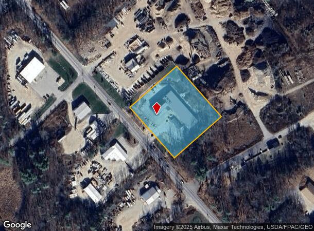
Property Record
290 Harold L Dow Hwy, Eliot, ME 03903

NEARBY LISTINGS FOR SALE OR LEASE
Property Detail
290 Harold L Dow Hwy
Commercialnec
York
X
Maine
23031C0645G
3.01 AC
2024
York County
2024
Portland/South Portland
037000
Portland-South Portland, ME
952 SF
ELIO-000037-000020
DEMOGRAPHICS near 290 Harold L Dow Hwy
1 Mile
3 Mile
5 Mile
2024 Total Population
746
9,091
38,426
2029 Population
779
9,527
40,338
Pop Growth 2024-2029
+ 4.42%
+ 4.80%
+ 4.98%
Average Age
45
45
44
2024 Total Households
307
3,791
17,315
HH Growth 2024-2029
+ 4.23%
+ 4.75%
+ 4.96%
Median Household Inc
$84,091
$90,594
$98,322
Avg Household Size
2.40
2.40
2.20
2024 Avg HH Vehicles
2.00
2.00
2.00
Median Home Value
$399,478
$404,890
$470,895
Median Year Built
1981
1980
1971
Nearby Places
Map Layers
Map Styles
 Street
 Aerial
- Restaurants
- Banks
- Shops
- Fitness
- Groceries
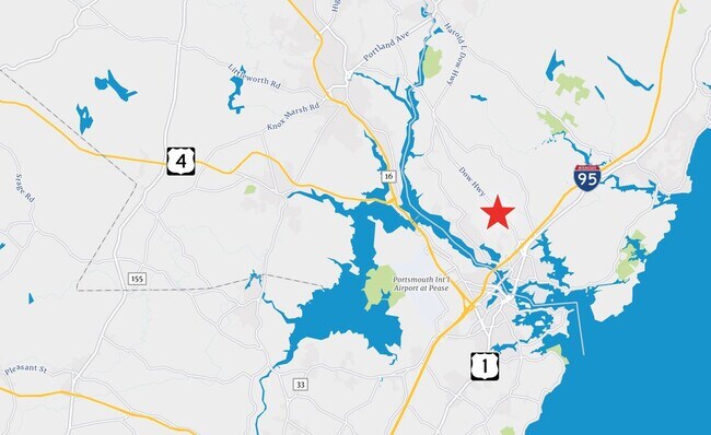
PUBLIC TRANSPORTATION
COMMUTER RAIL
Dover (Downeaster - Amtrak)
DRIVE
WALK
Distance
Dover (Downeaster - Amtrak)
15 min
7.7 mi
AIRPORT
Portsmouth International at Pease
DRIVE
WALK
Distance
Portsmouth International at Pease
15 min
7.5 mi
Freight Ports
Portland, ME
DRIVE
WALK
Distance
Portland, ME
62 min
51.6 mi
SALE & LEASE HISTORY
LISTING DATE
SALE/LEASE

May 22, 2023
For Lease
Nearby Properties
Address
Land Use
TOTAL SIZE
Lot Size
Zoning
Address
Land Use
TOTAL SIZE
Lot Size
Zoning
98.73 AC
C/I
Address
Land Use
TOTAL SIZE
Lot Size
Zoning
1,575 SF
52.95 AC
COMM
Address
Land Use
TOTAL SIZE
Lot Size
Zoning
22.33 AC
MU-N
Address
Land Use
TOTAL SIZE
Lot Size
Zoning
0.67 AC
VD
Address
Land Use
TOTAL SIZE
Lot Size
Zoning
48.95 AC
WIND
Address
Land Use
TOTAL SIZE
Lot Size
Zoning
3.78 AC
COMM
Address
Land Use
TOTAL SIZE
Lot Size
Zoning
64.76 AC
WIND
Address
Land Use
TOTAL SIZE
Lot Size
Zoning
3.97 AC
SD
Address
Land Use
TOTAL SIZE
Lot Size
Zoning
84,273 SF
13.61 AC
C-1
Address
Land Use
TOTAL SIZE
Lot Size
Zoning
9,060 SF
7.02 AC
IND
Address
Land Use
TOTAL SIZE
Lot Size
Zoning
5.45 AC
OFF
Address
Land Use
TOTAL SIZE
Lot Size
Zoning
238,513 SF
31.02 AC
COMM
Address
Land Use
TOTAL SIZE
Lot Size
Zoning
40,736 SF
14.82 AC
C-1
Address
Land Use
TOTAL SIZE
Lot Size
Zoning
101,643 SF
8.41 AC
OFF
Address
Land Use
TOTAL SIZE
Lot Size
Zoning
92,943 SF
8.55 AC
C-1
Address
Land Use
TOTAL SIZE
Lot Size
Zoning
275,051 SF
19.38 AC
COMM
Address
Land Use
TOTAL SIZE
Lot Size
Zoning
88,630 SF
5.50 AC
R-S
Address
Land Use
TOTAL SIZE
Lot Size
Zoning
117,164 SF
5.40 AC
C-3
Address
Land Use
TOTAL SIZE
Lot Size
Zoning
23.05 AC
VD
Address
Land Use
TOTAL SIZE
Lot Size
Zoning
74,246 SF
7.31 AC
COMM
Address
Land Use
TOTAL SIZE
Lot Size
Zoning
21.22 AC
OFF
Address
Land Use
TOTAL SIZE
Lot Size
Zoning
122,136 SF
12.95 AC
COMM
Address
Land Use
TOTAL SIZE
Lot Size
Zoning
64.31 AC
OR
Address
Land Use
TOTAL SIZE
Lot Size
Zoning
47,573 SF
1.96 AC
C-1
Address
Land Use
TOTAL SIZE
Lot Size
Zoning
7.49 AC
IND
Address
Land Use
TOTAL SIZE
Lot Size
Zoning
60,035 SF
7.23 AC
COMM
Address
Land Use
TOTAL SIZE
Lot Size
Zoning
66,492 SF
4.26 AC
COMM
Address
Land Use
TOTAL SIZE
Lot Size
Zoning
30 AC
SD
Address
Land Use
TOTAL SIZE
Lot Size
Zoning
6,160 SF
3.25 AC
C-1
Address
Land Use
TOTAL SIZE
Lot Size
Zoning
5.24 AC
OFF
The World's #1 Commercial Real Estate Marketplace
Connect with us
© 2026 CoStar Group
The information above has been obtained from sources believed reliable. While we do not doubt its accuracy we have not verified it and make no guarantee, warranty or representation about it. It is your responsibility to independently confirm its accuracy and completeness. Any projections, opinions, assumptions, or estimates used are for example only and do not represent the current or future performance of the property. The value of this transaction to you depends on tax and other factors which should be evaluated by your tax, financial, and legal advisors. You and your advisors should conduct a careful, independent investigation of the property to determine to your satisfaction the suitability of the property for your needs.