Property Record
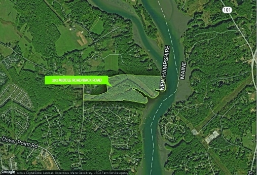
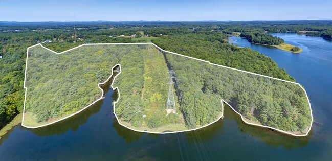
290 Middle Rd, Dover, NH 03820

Property Detail
290 Middle Rd
DOVR-000091-A000000-M000000
STRAFFORD
Industrialgeneral
New Hampshire
R-40
8.14 AC
AE The base floodplain where base flood elevations are provided. AE Zones are now used on new format FIRMs instead of A1-A30 Zones.
Strafford County
2024
Boston
2024
Boston-Cambridge-Newton, MA-NH
081300
NEARBY LISTINGS FOR SALE OR LEASE
DEMOGRAPHICS near 290 Middle Rd
1 mile
3 mile
5 mile
2025 Total Population
1,186
21,575
47,623
2030 Population
1,195
21,966
48,350
Pop Growth 2025-2030
+ 0.76%
+ 1.81%
+ 1.53%
Average Age
45
42
41
2025 Total Households
471
9,995
20,850
HH Growth 2025-2030
+ 0.64%
+ 2.01%
+ 1.67%
Median Household Inc
$169,697
$96,994
$96,247
Avg Household Size
2.50
2.10
2.20
2025 Avg HH Vehicles
2.00
2.00
2.00
Median Home Value
$574,418
$479,705
$466,300
Median Year Built
1987
1974
1975
Nearby Places
Map Layers
Map Styles
 Street
 Aerial
Transit
 Traffic
 Biking
Places
Listings with unknown addresses are not visible on the map
- Restaurants
- Banks
- Shops
- Fitness
- Groceries
PUBLIC TRANSPORTATION
COMMUTER RAIL
Dover (Downeaster - Amtrak)
Drive
Walk
Distance
Dover (Downeaster - Amtrak)
8 min
3.2 mi
Durham (Downeaster - Amtrak)
Drive
Walk
Distance
Durham (Downeaster - Amtrak)
18 min
7.5 mi
AIRPORT
Portsmouth International at Pease
Drive
Walk
Distance
Portsmouth International at Pease
16 min
7.7 mi
Freight Ports
Portland, ME
Drive
Walk
Distance
Portland, ME
74 min
51.8 mi
SALE & LEASE HISTORY
LISTING DATE
SALE/LEASE

Sep 30, 2020
For Sale
Sep 06, 2017
For Sale
Nearby Properties
Address
Land Use
TOTAL SIZE
Lot Size
Zoning
Address
Land Use
TOTAL SIZE
Lot Size
Zoning
24.83 AC
R-20
Address
Land Use
TOTAL SIZE
Lot Size
Zoning
1.26 AC
CBD-G
Address
Land Use
TOTAL SIZE
Lot Size
Zoning
0.67 AC
VD
Address
Land Use
TOTAL SIZE
Lot Size
Zoning
672 SF
50.98 AC
I1 IND
Address
Land Use
TOTAL SIZE
Lot Size
Zoning
20.03 AC
R-20
Address
Land Use
TOTAL SIZE
Lot Size
Zoning
3.66 AC
IT
Address
Land Use
TOTAL SIZE
Lot Size
Zoning
4.30 AC
I1 IND
Address
Land Use
TOTAL SIZE
Lot Size
Zoning
3.40 AC
CBD-M
Address
Land Use
TOTAL SIZE
Lot Size
Zoning
11.80 AC
R-12*
Address
Land Use
TOTAL SIZE
Lot Size
Zoning
26.40 AC
IT*
Address
Land Use
TOTAL SIZE
Lot Size
Zoning
60.41 AC
R-40
Address
Land Use
TOTAL SIZE
Lot Size
Zoning
3.35 AC
CBD-G
Address
Land Use
TOTAL SIZE
Lot Size
Zoning
3.66 AC
C
Address
Land Use
TOTAL SIZE
Lot Size
Zoning
7.92 AC
R-12
Address
Land Use
TOTAL SIZE
Lot Size
Zoning
0.22 AC
CBD-G
Address
Land Use
TOTAL SIZE
Lot Size
Zoning
4.15 AC
R-12
Address
Land Use
TOTAL SIZE
Lot Size
Zoning
11.47 AC
IT
Address
Land Use
TOTAL SIZE
Lot Size
Zoning
35.86 AC
R-40
Address
Land Use
TOTAL SIZE
Lot Size
Zoning
7.33 AC
G
Address
Land Use
TOTAL SIZE
Lot Size
Zoning
15.46 AC
G
Address
Land Use
TOTAL SIZE
Lot Size
Zoning
9.29 AC
R-12*
Address
Land Use
TOTAL SIZE
Lot Size
Zoning
11 AC
R-20
Address
Land Use
TOTAL SIZE
Lot Size
Zoning
0.74 AC
CBD-G
Address
Land Use
TOTAL SIZE
Lot Size
Zoning
57.28 AC
IT
Address
Land Use
TOTAL SIZE
Lot Size
Zoning
19 AC
RM-SU
Address
Land Use
TOTAL SIZE
Lot Size
Zoning
3.01 AC
IT
Address
Land Use
TOTAL SIZE
Lot Size
Zoning
0.75 AC
CBD-G
Address
Land Use
TOTAL SIZE
Lot Size
Zoning
1.29 AC
CBD-G
Address
Land Use
TOTAL SIZE
Lot Size
Zoning
1.56 AC
CBD-G
Address
Land Use
TOTAL SIZE
Lot Size
Zoning
1.05 AC
CBD-G
The World's #1 Commercial Real Estate Marketplace
Connect with us
© 2026 CoStar Group
The information above has been obtained from sources believed reliable. While we do not doubt its accuracy we have not verified it and make no guarantee, warranty or representation about it. It is your responsibility to independently confirm its accuracy and completeness. Any projections, opinions, assumptions, or estimates used are for example only and do not represent the current or future performance of the property. The value of this transaction to you depends on tax and other factors which should be evaluated by your tax, financial, and legal advisors. You and your advisors should conduct a careful, independent investigation of the property to determine to your satisfaction the suitability of the property for your needs.