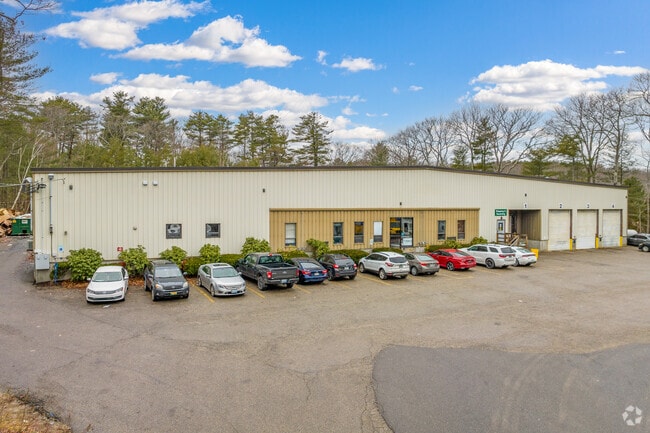
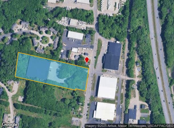
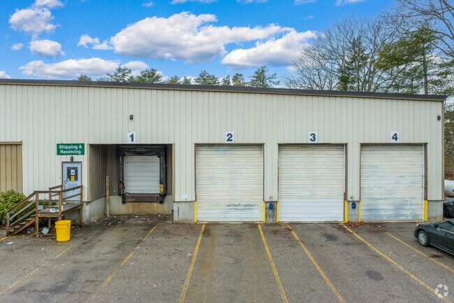
Property Record
290 Presumpscot St, Portland, ME 04103
NEARBY LISTINGS FOR SALE OR LEASE
Property Detail
290 Presumpscot St
Warehouse
Cumberland
X
Maine
23005C0684F
3.60 AC
2024
Bayside
2024
Portland/South Portland
002300
Portland-South Portland, ME
39,772 SF
PTLD-000423-000000-A030001
DEMOGRAPHICS near 290 Presumpscot St
1 Mile
3 Mile
5 Mile
2024 Total Population
6,326
65,572
109,522
2029 Population
6,494
67,646
113,111
Pop Growth 2024-2029
+ 2.66%
+ 3.16%
+ 3.28%
Average Age
43
41
42
2024 Total Households
2,805
31,220
50,224
HH Growth 2024-2029
+ 2.64%
+ 3.32%
+ 3.37%
Median Household Inc
$81,015
$69,805
$74,139
Avg Household Size
2.10
2.00
2.10
2024 Avg HH Vehicles
2.00
1.00
2.00
Median Home Value
$415,964
$434,417
$424,267
Median Year Built
1963
1952
1954
Nearby Places
Map Layers
Map Styles
 Street
 Aerial
- Restaurants
- Banks
- Shops
- Fitness
- Groceries
PUBLIC TRANSPORTATION
COMMUTER RAIL
Portland (Downeaster - Amtrak)
DRIVE
WALK
Distance
Portland (Downeaster - Amtrak)
8 min
3.8 mi
AIRPORT
Portland International Jetport
DRIVE
WALK
Distance
Portland International Jetport
14 min
6.0 mi
Freight Ports
Portland, ME
DRIVE
WALK
Distance
Portland, ME
7 min
3.0 mi
SALE & LEASE HISTORY
LISTING DATE
SALE/LEASE

Dec 08, 2020
For Lease
Aug 24, 2021
For Lease
Nearby Properties
Address
Land Use
TOTAL SIZE
Lot Size
Zoning
Address
Land Use
TOTAL SIZE
Lot Size
Zoning
8.11 AC
Address
Land Use
TOTAL SIZE
Lot Size
Zoning
12.51 AC
Address
Land Use
TOTAL SIZE
Lot Size
Zoning
32.33 AC
Address
Land Use
TOTAL SIZE
Lot Size
Zoning
260,061 SF
1.07 AC
Address
Land Use
TOTAL SIZE
Lot Size
Zoning
103,898 SF
0.66 AC
Address
Land Use
TOTAL SIZE
Lot Size
Zoning
5.13 AC
Address
Land Use
TOTAL SIZE
Lot Size
Zoning
1.12 AC
Address
Land Use
TOTAL SIZE
Lot Size
Zoning
86,510 SF
0.81 AC
Address
Land Use
TOTAL SIZE
Lot Size
Zoning
201,630 SF
0.45 AC
Address
Land Use
TOTAL SIZE
Lot Size
Zoning
130,659 SF
0.78 AC
Address
Land Use
TOTAL SIZE
Lot Size
Zoning
26,584 SF
2.79 AC
Address
Land Use
TOTAL SIZE
Lot Size
Zoning
266,228 SF
2.68 AC
Address
Land Use
TOTAL SIZE
Lot Size
Zoning
238,150 SF
1.37 AC
Address
Land Use
TOTAL SIZE
Lot Size
Zoning
285,570 SF
1.37 AC
Address
Land Use
TOTAL SIZE
Lot Size
Zoning
101,619 SF
0.55 AC
Address
Land Use
TOTAL SIZE
Lot Size
Zoning
1.59 AC
Address
Land Use
TOTAL SIZE
Lot Size
Zoning
181,344 SF
1.62 AC
Address
Land Use
TOTAL SIZE
Lot Size
Zoning
177,118 SF
0.91 AC
Address
Land Use
TOTAL SIZE
Lot Size
Zoning
10.18 AC
Address
Land Use
TOTAL SIZE
Lot Size
Zoning
135,968 SF
7.02 AC
Address
Land Use
TOTAL SIZE
Lot Size
Zoning
157,435 SF
2.28 AC
Address
Land Use
TOTAL SIZE
Lot Size
Zoning
84,627 SF
Address
Land Use
TOTAL SIZE
Lot Size
Zoning
76,957 SF
0.39 AC
Address
Land Use
TOTAL SIZE
Lot Size
Zoning
138,280 SF
0.59 AC
Address
Land Use
TOTAL SIZE
Lot Size
Zoning
9.11 AC
Address
Land Use
TOTAL SIZE
Lot Size
Zoning
75,370 SF
0.23 AC
Address
Land Use
TOTAL SIZE
Lot Size
Zoning
25.12 AC
Address
Land Use
TOTAL SIZE
Lot Size
Zoning
217 SF
8.65 AC
Address
Land Use
TOTAL SIZE
Lot Size
Zoning
80,189 SF
0.44 AC
Address
Land Use
TOTAL SIZE
Lot Size
Zoning
96,713 SF
The World's #1 Commercial Real Estate Marketplace
Connect with us
© 2025 CoStar Group
The information above has been obtained from sources believed reliable. While we do not doubt its accuracy we have not verified it and make no guarantee, warranty or representation about it. It is your responsibility to independently confirm its accuracy and completeness. Any projections, opinions, assumptions, or estimates used are for example only and do not represent the current or future performance of the property. The value of this transaction to you depends on tax and other factors which should be evaluated by your tax, financial, and legal advisors. You and your advisors should conduct a careful, independent investigation of the property to determine to your satisfaction the suitability of the property for your needs.