Property Record
290 Robins Way Sw, Concord, NC 28027
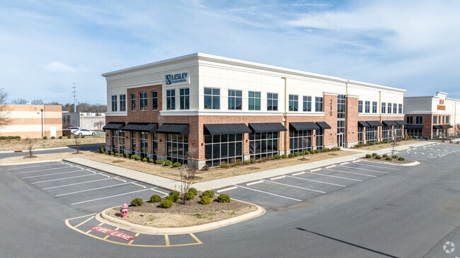
This Property Is For Sale
NEARBY LISTINGS FOR SALE OR LEASE
Property Detail
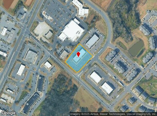
290 Robins Way Sw
Charlotte-Concord-Gastonia, NC-SC
Concord Parkway South
5509-43-2579-0000
LT 1 SETTLER'S LANDING COMMERCIAL LLC PROPERTY
Officebuilding
Cabarrus
X
North Carolina
3710550900K
1
2025
1.44 AC
2025
Cabarrus County
042603
Charlotte
20,620 SF
DEMOGRAPHICS near 290 Robins Way Sw
1 Mile
3 Mile
5 Mile
2024 Total Population
5,662
36,198
116,584
2029 Population
6,343
40,639
129,536
Pop Growth 2024-2029
+ 12.03%
+ 12.27%
+ 11.11%
Average Age
37
39
37
2024 Total Households
2,014
13,583
43,660
HH Growth 2024-2029
+ 10.58%
+ 10.91%
+ 10.00%
Median Household Inc
$101,695
$94,910
$82,289
Avg Household Size
2.70
2.60
2.60
2024 Avg HH Vehicles
2.00
2.00
2.00
Median Home Value
$263,040
$288,471
$290,251
Median Year Built
1998
2000
2001
Nearby Places
Map Layers
Map Styles
 Street
 Aerial
- Restaurants
- Banks
- Shops
- Fitness
- Groceries
PUBLIC TRANSPORTATION
AIRPORT
Concord-Padgett Regional
DRIVE
WALK
Distance
Concord-Padgett Regional
13 min
6.3 mi
Charlotte/Douglas International
DRIVE
WALK
Distance
Charlotte/Douglas International
38 min
24.7 mi
Freight Ports
Port of Wilmington
DRIVE
WALK
Distance
Port of Wilmington
256 min
204.2 mi
Nearby Properties
Address
Land Use
TOTAL SIZE
Lot Size
Zoning
Address
Land Use
TOTAL SIZE
Lot Size
Zoning
122,131 SF
415.58 AC
I-2
Address
Land Use
TOTAL SIZE
Lot Size
Zoning
154,304 SF
857.72 AC
PID
Address
Land Use
TOTAL SIZE
Lot Size
Zoning
381,490 SF
29.24 AC
C-2
Address
Land Use
TOTAL SIZE
Lot Size
Zoning
324,349 SF
4.69 AC
C-2
Address
Land Use
TOTAL SIZE
Lot Size
Zoning
14,742 SF
587.28 AC
I-1
Address
Land Use
TOTAL SIZE
Lot Size
Zoning
33,090 SF
19.43 AC
C-2
Address
Land Use
TOTAL SIZE
Lot Size
Zoning
23,940 SF
45.03 AC
C-1
Address
Land Use
TOTAL SIZE
Lot Size
Zoning
29,658 SF
17.25 AC
MX-IB
Address
Land Use
TOTAL SIZE
Lot Size
Zoning
57,268 SF
25.88 AC
C-2
Address
Land Use
TOTAL SIZE
Lot Size
Zoning
5,048 SF
26.66 AC
C-2
Address
Land Use
TOTAL SIZE
Lot Size
Zoning
333,623 SF
108.12 AC
RV
Address
Land Use
TOTAL SIZE
Lot Size
Zoning
495.38 AC
I-2
Address
Land Use
TOTAL SIZE
Lot Size
Zoning
300,275 SF
20.78 AC
MX2
Address
Land Use
TOTAL SIZE
Lot Size
Zoning
670.09 AC
I-2
Address
Land Use
TOTAL SIZE
Lot Size
Zoning
260,820 SF
14.72 AC
R3
Address
Land Use
TOTAL SIZE
Lot Size
Zoning
43,005 SF
97.30 AC
RM-2
Address
Land Use
TOTAL SIZE
Lot Size
Zoning
196,893 SF
43.82 AC
MDR
Address
Land Use
TOTAL SIZE
Lot Size
Zoning
22,198 SF
18.46 AC
C-2
Address
Land Use
TOTAL SIZE
Lot Size
Zoning
163,494 SF
89.85 AC
I-2
Address
Land Use
TOTAL SIZE
Lot Size
Zoning
245,838 SF
6.13 AC
Address
Land Use
TOTAL SIZE
Lot Size
Zoning
350,339 SF
77.60 AC
RM-1
Address
Land Use
TOTAL SIZE
Lot Size
Zoning
203,931 SF
44.99 AC
RM-2
Address
Land Use
TOTAL SIZE
Lot Size
Zoning
252,810 SF
6.87 AC
UR-C(CD)
Address
Land Use
TOTAL SIZE
Lot Size
Zoning
55,158 SF
63.68 AC
O-I
Address
Land Use
TOTAL SIZE
Lot Size
Zoning
38,595 SF
11.71 AC
RC
Address
Land Use
TOTAL SIZE
Lot Size
Zoning
7,566 SF
19.98 AC
RC
Address
Land Use
TOTAL SIZE
Lot Size
Zoning
477,848 SF
37.66 AC
I-2
Address
Land Use
TOTAL SIZE
Lot Size
Zoning
307,198 SF
20.96 AC
I-2-CD
Address
Land Use
TOTAL SIZE
Lot Size
Zoning
143,040 SF
8.05 AC
I-2
Address
Land Use
TOTAL SIZE
Lot Size
Zoning
96,607 SF
15.13 AC
I-1
The World's #1 Commercial Real Estate Marketplace
Connect with us
© 2025 CoStar Group
The information above has been obtained from sources believed reliable. While we do not doubt its accuracy we have not verified it and make no guarantee, warranty or representation about it. It is your responsibility to independently confirm its accuracy and completeness. Any projections, opinions, assumptions, or estimates used are for example only and do not represent the current or future performance of the property. The value of this transaction to you depends on tax and other factors which should be evaluated by your tax, financial, and legal advisors. You and your advisors should conduct a careful, independent investigation of the property to determine to your satisfaction the suitability of the property for your needs.