Property Record
290 Tower Rd, Ponchatoula, LA 70454
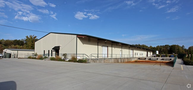

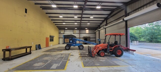


Property Detail
290 Tower Rd
06216498
4.00A BEING TR B2 OF CITY OF PONCHATOULA INDUSTRIAL PARK IN SEC 45 T7SR8E PONCH B1059 P545 B1083 P878 B1623 P704 B1636 P45 MA
Commercialnec
Tangipahoa
B and X Area of moderate flood hazard, usually the area between the limits of the 100-year and 500-year floods.
Louisiana
2025
4 AC
2025
Louisiana South Area
954700
Other Market Areas
21,600 SF
Hammond, LA
NEARBY LISTINGS FOR SALE OR LEASE
DEMOGRAPHICS near 290 Tower Rd
1 mile
3 mile
5 mile
2025 Total Population
3,350
16,068
36,940
2030 Population
3,455
16,659
38,314
Pop Growth 2025-2030
+ 3.13%
+ 3.68%
+ 3.72%
Average Age
40
40
39
2025 Total Households
1,363
6,391
14,520
HH Growth 2025-2030
+ 3.30%
+ 3.82%
+ 3.88%
Median Household Inc
$51,028
$65,374
$62,734
Avg Household Size
2.40
2.50
2.50
2025 Avg HH Vehicles
2.00
2.00
2.00
Median Home Value
$209,250
$239,441
$238,116
Median Year Built
1978
2001
2000
Nearby Places
Map Layers
Map Styles
 Street
 Aerial
Layers
 Traffic
 Biking
Places
Listings with unknown addresses are not visible on the map
- Restaurants
- Banks
- Shops
- Fitness
- Groceries
SALE & LEASE HISTORY
LISTING DATE
SALE/LEASE

Aug 26, 2021
For Lease
Aug 26, 2021
For Sale
Apr 24, 2017
For Lease
Nearby Properties
Address
Land Use
TOTAL SIZE
Lot Size
Zoning
Address
Land Use
TOTAL SIZE
Lot Size
Zoning
22.56 AC
Address
Land Use
TOTAL SIZE
Lot Size
Zoning
327,625 SF
14.78 AC
Address
Land Use
TOTAL SIZE
Lot Size
Zoning
152,841 SF
20.69 AC
Address
Land Use
TOTAL SIZE
Lot Size
Zoning
84,000 SF
8.32 AC
Address
Land Use
TOTAL SIZE
Lot Size
Zoning
24,823 SF
3 AC
Address
Land Use
TOTAL SIZE
Lot Size
Zoning
36,593 SF
1.54 AC
Address
Land Use
TOTAL SIZE
Lot Size
Zoning
27,215 SF
7.58 AC
Address
Land Use
TOTAL SIZE
Lot Size
Zoning
120,800 SF
10 AC
Address
Land Use
TOTAL SIZE
Lot Size
Zoning
80,000 SF
11.02 AC
Address
Land Use
TOTAL SIZE
Lot Size
Zoning
10,944 SF
2.16 AC
Address
Land Use
TOTAL SIZE
Lot Size
Zoning
16,780 SF
8.41 AC
Address
Land Use
TOTAL SIZE
Lot Size
Zoning
236,540 SF
36.01 AC
Address
Land Use
TOTAL SIZE
Lot Size
Zoning
13,288 SF
15.07 AC
Address
Land Use
TOTAL SIZE
Lot Size
Zoning
67,728 SF
6.78 AC
Address
Land Use
TOTAL SIZE
Lot Size
Zoning
96,000 SF
7.29 AC
Address
Land Use
TOTAL SIZE
Lot Size
Zoning
12,021 SF
1.15 AC
Address
Land Use
TOTAL SIZE
Lot Size
Zoning
51,390 SF
16 AC
Address
Land Use
TOTAL SIZE
Lot Size
Zoning
14,850 SF
6.91 AC
Address
Land Use
TOTAL SIZE
Lot Size
Zoning
10,772 SF
1.28 AC
Address
Land Use
TOTAL SIZE
Lot Size
Zoning
1.43 AC
Address
Land Use
TOTAL SIZE
Lot Size
Zoning
12,642 SF
1.22 AC
Address
Land Use
TOTAL SIZE
Lot Size
Zoning
9,175 SF
0.70 AC
Address
Land Use
TOTAL SIZE
Lot Size
Zoning
44,720 SF
5.38 AC
Address
Land Use
TOTAL SIZE
Lot Size
Zoning
15,391 SF
1.61 AC
Address
Land Use
TOTAL SIZE
Lot Size
Zoning
4,168 SF
1.22 AC
Address
Land Use
TOTAL SIZE
Lot Size
Zoning
24,222 SF
6.72 AC
Address
Land Use
TOTAL SIZE
Lot Size
Zoning
9,996 SF
1.72 AC
Address
Land Use
TOTAL SIZE
Lot Size
Zoning
600 SF
0.63 AC
Address
Land Use
TOTAL SIZE
Lot Size
Zoning
22,862 SF
1.29 AC
The World's #1 Commercial Real Estate Marketplace
Connect with us
© 2026 CoStar Group
The information above has been obtained from sources believed reliable. While we do not doubt its accuracy we have not verified it and make no guarantee, warranty or representation about it. It is your responsibility to independently confirm its accuracy and completeness. Any projections, opinions, assumptions, or estimates used are for example only and do not represent the current or future performance of the property. The value of this transaction to you depends on tax and other factors which should be evaluated by your tax, financial, and legal advisors. You and your advisors should conduct a careful, independent investigation of the property to determine to your satisfaction the suitability of the property for your needs.