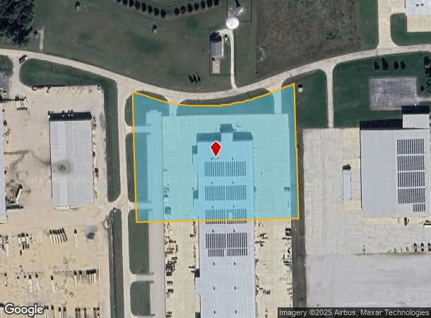
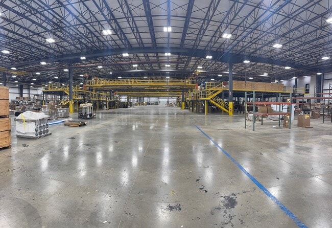
Property Record
290 W 750 N, Howe, IN 46746
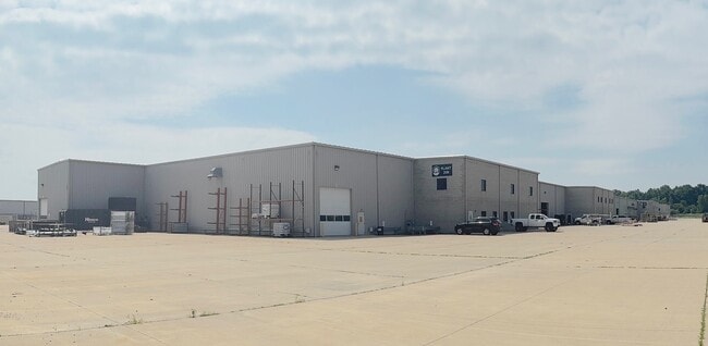
This Property Is For Sale
NEARBY LISTINGS FOR SALE OR LEASE
Property Detail
290 W 750 N
44-03-13-400-012.004-012
HOWE 121 PARK SECTION TWO LOT 7 7.77 AC
Manufacturinglight
LaGrange
X
Indiana
18087C0070C
7
2024
7.77 AC
2024
Indiana North Area
970100
Other Market Areas
205,156 SF
DEMOGRAPHICS near 290 W 750 N
1 Mile
3 Mile
5 Mile
2024 Total Population
209
4,009
17,923
2029 Population
214
4,013
17,851
Pop Growth 2024-2029
+ 2.39%
+ 0.10%
(0.40%)
Average Age
39
38
38
2024 Total Households
74
1,528
6,627
HH Growth 2024-2029
+ 1.35%
(0.26%)
(0.59%)
Median Household Inc
$96,428
$66,289
$66,587
Avg Household Size
2.90
2.60
2.70
2024 Avg HH Vehicles
2.00
2.00
2.00
Median Home Value
$314,286
$181,548
$163,927
Median Year Built
1979
1973
1966
Nearby Places
Map Layers
Map Styles
 Street
 Aerial
- Restaurants
- Banks
- Shops
- Fitness
- Groceries
Nearby Properties
Address
Land Use
TOTAL SIZE
Lot Size
Zoning
Address
Land Use
TOTAL SIZE
Lot Size
Zoning
198,796 SF
22.23 AC
Address
Land Use
TOTAL SIZE
Lot Size
Zoning
211,891 SF
41.12 AC
Address
Land Use
TOTAL SIZE
Lot Size
Zoning
156,250 SF
12.55 AC
Address
Land Use
TOTAL SIZE
Lot Size
Zoning
105,240 SF
22.67 AC
Address
Land Use
TOTAL SIZE
Lot Size
Zoning
347,990 SF
17.69 AC
Address
Land Use
TOTAL SIZE
Lot Size
Zoning
261,207 SF
8.60 AC
Address
Land Use
TOTAL SIZE
Lot Size
Zoning
206,086 SF
46.21 AC
Address
Land Use
TOTAL SIZE
Lot Size
Zoning
36,780 SF
10.60 AC
Address
Land Use
TOTAL SIZE
Lot Size
Zoning
87,681 SF
20 AC
Address
Land Use
TOTAL SIZE
Lot Size
Zoning
27.16 AC
Address
Land Use
TOTAL SIZE
Lot Size
Zoning
231,615 SF
6.37 AC
Address
Land Use
TOTAL SIZE
Lot Size
Zoning
172,370 SF
16 AC
Address
Land Use
TOTAL SIZE
Lot Size
Zoning
31,120 SF
7.56 AC
Address
Land Use
TOTAL SIZE
Lot Size
Zoning
Address
Land Use
TOTAL SIZE
Lot Size
Zoning
50,400 SF
7.65 AC
Address
Land Use
TOTAL SIZE
Lot Size
Zoning
31,644 SF
3.11 AC
A (AGI)
Address
Land Use
TOTAL SIZE
Lot Size
Zoning
79,931 SF
5.38 AC
Address
Land Use
TOTAL SIZE
Lot Size
Zoning
19,220 SF
4.46 AC
Address
Land Use
TOTAL SIZE
Lot Size
Zoning
163,959 SF
62.96 AC
Address
Land Use
TOTAL SIZE
Lot Size
Zoning
33,390 SF
3.16 AC
Address
Land Use
TOTAL SIZE
Lot Size
Zoning
181,484 SF
35.13 AC
Address
Land Use
TOTAL SIZE
Lot Size
Zoning
31,551 SF
2.04 AC
Address
Land Use
TOTAL SIZE
Lot Size
Zoning
6,608 SF
3.31 AC
Address
Land Use
TOTAL SIZE
Lot Size
Zoning
181,398 SF
14.38 AC
Address
Land Use
TOTAL SIZE
Lot Size
Zoning
9,373 SF
4.72 AC
Address
Land Use
TOTAL SIZE
Lot Size
Zoning
108,312 SF
18.57 AC
Address
Land Use
TOTAL SIZE
Lot Size
Zoning
14,820 SF
1.58 AC
Address
Land Use
TOTAL SIZE
Lot Size
Zoning
31,178 SF
5 AC
Address
Land Use
TOTAL SIZE
Lot Size
Zoning
The World's #1 Commercial Real Estate Marketplace
Connect with us
© 2025 CoStar Group
The information above has been obtained from sources believed reliable. While we do not doubt its accuracy we have not verified it and make no guarantee, warranty or representation about it. It is your responsibility to independently confirm its accuracy and completeness. Any projections, opinions, assumptions, or estimates used are for example only and do not represent the current or future performance of the property. The value of this transaction to you depends on tax and other factors which should be evaluated by your tax, financial, and legal advisors. You and your advisors should conduct a careful, independent investigation of the property to determine to your satisfaction the suitability of the property for your needs.