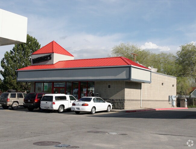
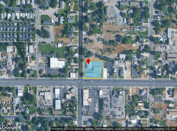
Property Record
290 W Main St, American Fork, UT 84003
NEARBY LISTINGS FOR SALE OR LEASE
Property Detail
290 W Main St
Provo-Orem, UT
COM AT SW COR. LOT 2, BLK. 21, PLAT A, AMERICAN FORK CITY SURVEY; N 0 DEG 29 58 E 181.5 FT; S 89 DEG 30 22 E 198 FT; S 0 DEG 29 58 W 181.5 FT; N 89 DEG 30 22 W 198 FT TO BEG. AREA 0.825 AC.
02-034-0008
Utah
Carwash
Utah
2024
2
2025
0.83 AC
000207
Utah County
6,169 SF
Salt Lake City
DEMOGRAPHICS near 290 W Main St
1 Mile
3 Mile
5 Mile
2024 Total Population
11,079
77,791
167,515
2029 Population
12,922
90,996
195,779
Pop Growth 2024-2029
+ 16.64%
+ 16.97%
+ 16.87%
Average Age
32
32
32
2024 Total Households
3,359
22,573
46,183
HH Growth 2024-2029
+ 16.91%
+ 17.42%
+ 17.26%
Median Household Inc
$79,827
$93,739
$105,837
Avg Household Size
3.20
3.40
3.60
2024 Avg HH Vehicles
2.00
2.00
2.00
Median Home Value
$404,071
$475,297
$507,747
Median Year Built
1986
2001
2002
Nearby Places
Map Layers
Map Styles
 Street
 Aerial
- Restaurants
- Banks
- Shops
- Fitness
- Groceries
PUBLIC TRANSPORTATION
COMMUTER RAIL
DRIVE
WALK
Distance
3 min
1.2 mi
DRIVE
WALK
Distance
12 min
7.1 mi
AIRPORT
Provo Municipal
DRIVE
WALK
Distance
Provo Municipal
23 min
16.8 mi
Salt Lake City International
DRIVE
WALK
Distance
Salt Lake City International
42 min
35.2 mi
Nearby Properties
Address
Land Use
TOTAL SIZE
Lot Size
Zoning
Address
Land Use
TOTAL SIZE
Lot Size
Zoning
587,192 SF
48.27 AC
Address
Land Use
TOTAL SIZE
Lot Size
Zoning
287,823 SF
8.96 AC
Address
Land Use
TOTAL SIZE
Lot Size
Zoning
201,081 SF
17.96 AC
Address
Land Use
TOTAL SIZE
Lot Size
Zoning
400,684 SF
10.39 AC
Address
Land Use
TOTAL SIZE
Lot Size
Zoning
322,826 SF
9.53 AC
Address
Land Use
TOTAL SIZE
Lot Size
Zoning
291,932 SF
8.10 AC
Address
Land Use
TOTAL SIZE
Lot Size
Zoning
194,977 SF
8.18 AC
Address
Land Use
TOTAL SIZE
Lot Size
Zoning
359,445 SF
6.46 AC
Address
Land Use
TOTAL SIZE
Lot Size
Zoning
305,553 SF
13.08 AC
Address
Land Use
TOTAL SIZE
Lot Size
Zoning
327,092 SF
14.61 AC
Address
Land Use
TOTAL SIZE
Lot Size
Zoning
146,939 SF
36.63 AC
Address
Land Use
TOTAL SIZE
Lot Size
Zoning
268,989 SF
12.78 AC
Address
Land Use
TOTAL SIZE
Lot Size
Zoning
8.99 AC
Address
Land Use
TOTAL SIZE
Lot Size
Zoning
154,800 SF
9.14 AC
Address
Land Use
TOTAL SIZE
Lot Size
Zoning
227,030 SF
21.91 AC
Address
Land Use
TOTAL SIZE
Lot Size
Zoning
213,863 SF
11.71 AC
Address
Land Use
TOTAL SIZE
Lot Size
Zoning
201,838 SF
8.83 AC
Address
Land Use
TOTAL SIZE
Lot Size
Zoning
141,635 SF
10.58 AC
Address
Land Use
TOTAL SIZE
Lot Size
Zoning
182,338 SF
7.97 AC
Address
Land Use
TOTAL SIZE
Lot Size
Zoning
153,790 SF
12.07 AC
Address
Land Use
TOTAL SIZE
Lot Size
Zoning
200,016 SF
8.82 AC
Address
Land Use
TOTAL SIZE
Lot Size
Zoning
122,777 SF
6.68 AC
Address
Land Use
TOTAL SIZE
Lot Size
Zoning
141,204 SF
11.96 AC
Address
Land Use
TOTAL SIZE
Lot Size
Zoning
149,937 SF
13.49 AC
Address
Land Use
TOTAL SIZE
Lot Size
Zoning
409,362 SF
29.53 AC
Address
Land Use
TOTAL SIZE
Lot Size
Zoning
102,751 SF
6.20 AC
Address
Land Use
TOTAL SIZE
Lot Size
Zoning
143,438 SF
7.43 AC
Address
Land Use
TOTAL SIZE
Lot Size
Zoning
100,814 SF
8.22 AC
Address
Land Use
TOTAL SIZE
Lot Size
Zoning
62,104 SF
8.97 AC
Address
Land Use
TOTAL SIZE
Lot Size
Zoning
94,851 SF
6.10 AC
The World's #1 Commercial Real Estate Marketplace
Connect with us
© 2025 CoStar Group
The information above has been obtained from sources believed reliable. While we do not doubt its accuracy we have not verified it and make no guarantee, warranty or representation about it. It is your responsibility to independently confirm its accuracy and completeness. Any projections, opinions, assumptions, or estimates used are for example only and do not represent the current or future performance of the property. The value of this transaction to you depends on tax and other factors which should be evaluated by your tax, financial, and legal advisors. You and your advisors should conduct a careful, independent investigation of the property to determine to your satisfaction the suitability of the property for your needs.