Property Record
2900 Alta Mere Dr, Fort Worth, TX 76116
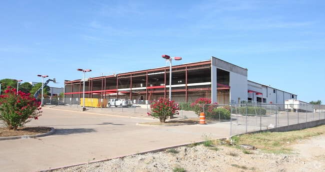


Property Detail
2900 Alta Mere Dr
Dallas-Fort Worth-Arlington, TX
ALTA MERE ADDITION BLOCK 7-R-1-R LOT 1-B-R
41673972
TARRANT
Commercialnec
Texas
B and X Area of moderate flood hazard, usually the area between the limits of the 100-year and 500-year floods.
1-b
0
9.61 AC
2025
West Fort Worth
102301
Dallas/Ft Worth
60,842 SF
NEARBY LISTINGS FOR SALE OR LEASE
DEMOGRAPHICS near 2900 Alta Mere Dr
1 mile
3 mile
5 mile
2025 Total Population
11,142
99,643
213,607
2030 Population
11,848
105,696
227,383
Pop Growth 2025-2030
+ 6.34%
+ 6.07%
+ 6.45%
Average Age
36
38
38
2025 Total Households
4,644
42,711
89,393
HH Growth 2025-2030
+ 6.40%
+ 6.17%
+ 6.46%
Median Household Inc
$32,576
$59,764
$70,301
Avg Household Size
2.30
2.30
2.30
2025 Avg HH Vehicles
1.00
2.00
2.00
Median Home Value
$272,649
$303,334
$338,431
Median Year Built
1976
1979
1982
Nearby Places
Map Layers
Map Styles
 Street
 Aerial
Layers
 Traffic
 Biking
Places
Listings with unknown addresses are not visible on the map
- Restaurants
- Banks
- Shops
- Fitness
- Groceries
PUBLIC TRANSPORTATION
COMMUTER RAIL
Texas And Pacific (T&P) (Trinity Railway Express - Dallas Area Rapid Transit (DART))
Drive
Walk
Distance
Texas And Pacific (T&P) (Trinity Railway Express - Dallas Area Rapid Transit (DART))
13 min
7.6 mi
Fort Worth (Heartland Flyer - Amtrak, Texas Eagle - Amtrak)
Drive
Walk
Distance
Fort Worth (Heartland Flyer - Amtrak, Texas Eagle - Amtrak)
13 min
8.0 mi
AIRPORT
Dallas-Fort Worth International
Drive
Walk
Distance
Dallas-Fort Worth International
43 min
32.5 mi
Freight Ports
Port of Shreveport
Drive
Walk
Distance
Port of Shreveport
254 min
236.7 mi
Nearby Properties
Address
Land Use
TOTAL SIZE
Lot Size
Zoning
Address
Land Use
TOTAL SIZE
Lot Size
Zoning
505,069 SF
6.49 AC
Address
Land Use
TOTAL SIZE
Lot Size
Zoning
477,907 SF
11.83 AC
Address
Land Use
TOTAL SIZE
Lot Size
Zoning
346,920 SF
9.88 AC
Address
Land Use
TOTAL SIZE
Lot Size
Zoning
492,130 SF
6.55 AC
Address
Land Use
TOTAL SIZE
Lot Size
Zoning
355,125 SF
21.29 AC
Address
Land Use
TOTAL SIZE
Lot Size
Zoning
314,284 SF
26.29 AC
Address
Land Use
TOTAL SIZE
Lot Size
Zoning
350,654 SF
21.29 AC
Address
Land Use
TOTAL SIZE
Lot Size
Zoning
296,664 SF
14.71 AC
Address
Land Use
TOTAL SIZE
Lot Size
Zoning
347,423 SF
7.32 AC
Address
Land Use
TOTAL SIZE
Lot Size
Zoning
242,244 SF
27.01 AC
Address
Land Use
TOTAL SIZE
Lot Size
Zoning
424,333 SF
12.59 AC
Address
Land Use
TOTAL SIZE
Lot Size
Zoning
315,552 SF
14.84 AC
Address
Land Use
TOTAL SIZE
Lot Size
Zoning
267,098 SF
14.06 AC
Address
Land Use
TOTAL SIZE
Lot Size
Zoning
166,474 SF
12.60 AC
Address
Land Use
TOTAL SIZE
Lot Size
Zoning
372,523 SF
3.46 AC
Address
Land Use
TOTAL SIZE
Lot Size
Zoning
271,065 SF
9.03 AC
Address
Land Use
TOTAL SIZE
Lot Size
Zoning
252,703 SF
14.35 AC
Address
Land Use
TOTAL SIZE
Lot Size
Zoning
179,980 SF
2.67 AC
Address
Land Use
TOTAL SIZE
Lot Size
Zoning
172,520 SF
2.37 AC
Address
Land Use
TOTAL SIZE
Lot Size
Zoning
152,640 SF
15.91 AC
Address
Land Use
TOTAL SIZE
Lot Size
Zoning
228,609 SF
9.86 AC
Address
Land Use
TOTAL SIZE
Lot Size
Zoning
189,598 SF
8.91 AC
Address
Land Use
TOTAL SIZE
Lot Size
Zoning
215,548 SF
7.79 AC
Address
Land Use
TOTAL SIZE
Lot Size
Zoning
357,676 SF
9.03 AC
Address
Land Use
TOTAL SIZE
Lot Size
Zoning
136,717 SF
12.07 AC
Address
Land Use
TOTAL SIZE
Lot Size
Zoning
284,418 SF
15.86 AC
Address
Land Use
TOTAL SIZE
Lot Size
Zoning
213,808 SF
16.65 AC
Address
Land Use
TOTAL SIZE
Lot Size
Zoning
238,580 SF
11.56 AC
Address
Land Use
TOTAL SIZE
Lot Size
Zoning
222,000 SF
12 AC
Address
Land Use
TOTAL SIZE
Lot Size
Zoning
352,323 SF
7.71 AC
The World's #1 Commercial Real Estate Marketplace
Connect with us
© 2026 CoStar Group
The information above has been obtained from sources believed reliable. While we do not doubt its accuracy we have not verified it and make no guarantee, warranty or representation about it. It is your responsibility to independently confirm its accuracy and completeness. Any projections, opinions, assumptions, or estimates used are for example only and do not represent the current or future performance of the property. The value of this transaction to you depends on tax and other factors which should be evaluated by your tax, financial, and legal advisors. You and your advisors should conduct a careful, independent investigation of the property to determine to your satisfaction the suitability of the property for your needs.