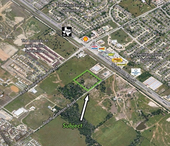
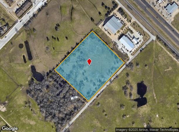
Property Record
N Graham Rd, College Station, TX 77845


NEARBY LISTINGS FOR SALE OR LEASE
Property Detail
N Graham Rd
College Station-Bryan, TX
Crawford Burnett (Icl)
84347
A000701, CRAWFORD BURNETT (ICL), TRACT 38.4, 7.366 ACRES
Agriculturalland
Brazos
X
Texas
48041C0310F
38.4
2024
7.37 AC
2025
Bryan & College Station
002019
Other Market Areas
DEMOGRAPHICS near N Graham Rd
1 Mile
3 Mile
5 Mile
2024 Total Population
10,434
75,128
133,423
2029 Population
11,127
80,936
144,104
Pop Growth 2024-2029
+ 6.64%
+ 7.73%
+ 8.01%
Average Age
31
31
30
2024 Total Households
3,880
27,540
47,628
HH Growth 2024-2029
+ 7.16%
+ 8.27%
+ 8.91%
Median Household Inc
$46,692
$47,298
$45,636
Avg Household Size
2.60
2.50
2.40
2024 Avg HH Vehicles
2.00
2.00
2.00
Median Home Value
$248,896
$283,771
$320,034
Median Year Built
2002
1998
1998
Nearby Places
- Restaurants
- Banks
- Shops
- Fitness
- Groceries
PUBLIC TRANSPORTATION
AIRPORT
Easterwood Field
DRIVE
WALK
Distance
Easterwood Field
16 min
6.3 mi
Freight Ports
Port of Houston
DRIVE
WALK
Distance
Port of Houston
120 min
95.9 mi
SALE & LEASE HISTORY
LISTING DATE
SALE/LEASE

Sep 24, 2016
For Sale
Nearby Properties
Address
Land Use
TOTAL SIZE
Lot Size
Zoning
Address
Land Use
TOTAL SIZE
Lot Size
Zoning
1,260,324 SF
47.72 AC
Address
Land Use
TOTAL SIZE
Lot Size
Zoning
397,850 SF
54.54 AC
Address
Land Use
TOTAL SIZE
Lot Size
Zoning
Address
Land Use
TOTAL SIZE
Lot Size
Zoning
527,220 SF
41.58 AC
Address
Land Use
TOTAL SIZE
Lot Size
Zoning
369,909 SF
29.84 AC
Address
Land Use
TOTAL SIZE
Lot Size
Zoning
294,267 SF
13.80 AC
Address
Land Use
TOTAL SIZE
Lot Size
Zoning
353,843 SF
36.83 AC
Address
Land Use
TOTAL SIZE
Lot Size
Zoning
409,205 SF
26.99 AC
Address
Land Use
TOTAL SIZE
Lot Size
Zoning
320,852 SF
28.12 AC
Address
Land Use
TOTAL SIZE
Lot Size
Zoning
311,236 SF
20.24 AC
Address
Land Use
TOTAL SIZE
Lot Size
Zoning
412,292 SF
31.12 AC
Address
Land Use
TOTAL SIZE
Lot Size
Zoning
382,342 SF
40 AC
Address
Land Use
TOTAL SIZE
Lot Size
Zoning
281,500 SF
16.67 AC
Address
Land Use
TOTAL SIZE
Lot Size
Zoning
353,988 SF
17.66 AC
Address
Land Use
TOTAL SIZE
Lot Size
Zoning
359,171 SF
16.98 AC
Address
Land Use
TOTAL SIZE
Lot Size
Zoning
284,699 SF
15.21 AC
Address
Land Use
TOTAL SIZE
Lot Size
Zoning
283,322 SF
14.78 AC
Address
Land Use
TOTAL SIZE
Lot Size
Zoning
267,852 SF
17.91 AC
Address
Land Use
TOTAL SIZE
Lot Size
Zoning
232,343 SF
23.33 AC
Address
Land Use
TOTAL SIZE
Lot Size
Zoning
222,990 SF
16.24 AC
Address
Land Use
TOTAL SIZE
Lot Size
Zoning
218,263 SF
8.92 AC
Address
Land Use
TOTAL SIZE
Lot Size
Zoning
242,681 SF
22.18 AC
Address
Land Use
TOTAL SIZE
Lot Size
Zoning
283,935 SF
11.06 AC
Address
Land Use
TOTAL SIZE
Lot Size
Zoning
235,145 SF
3.12 AC
Address
Land Use
TOTAL SIZE
Lot Size
Zoning
127,791 SF
1 AC
Address
Land Use
TOTAL SIZE
Lot Size
Zoning
265,628 SF
20.30 AC
Address
Land Use
TOTAL SIZE
Lot Size
Zoning
205,490 SF
7.10 AC
Address
Land Use
TOTAL SIZE
Lot Size
Zoning
163,000 SF
3.14 AC
Address
Land Use
TOTAL SIZE
Lot Size
Zoning
213,331 SF
12.06 AC
Address
Land Use
TOTAL SIZE
Lot Size
Zoning
250,223 SF
11.19 AC
The World's #1 Commercial Real Estate Marketplace
Connect with us
© 2025 CoStar Group
The information above has been obtained from sources believed reliable. While we do not doubt its accuracy we have not verified it and make no guarantee, warranty or representation about it. It is your responsibility to independently confirm its accuracy and completeness. Any projections, opinions, assumptions, or estimates used are for example only and do not represent the current or future performance of the property. The value of this transaction to you depends on tax and other factors which should be evaluated by your tax, financial, and legal advisors. You and your advisors should conduct a careful, independent investigation of the property to determine to your satisfaction the suitability of the property for your needs.