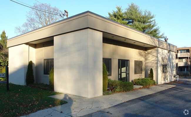
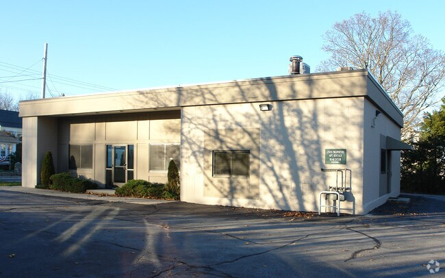
Property Record
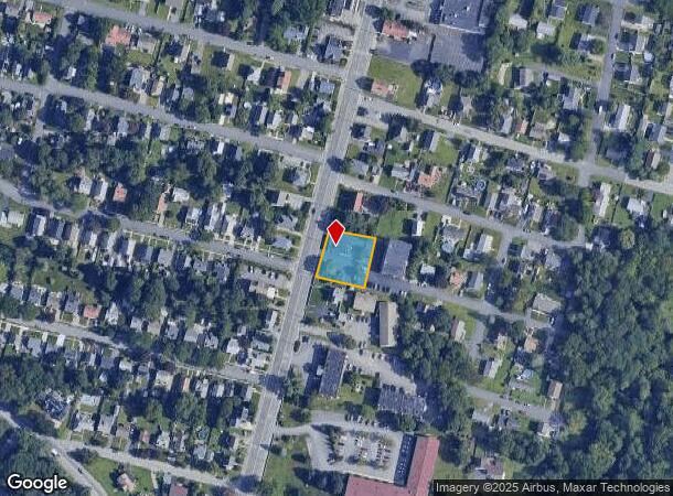
2900 Pawtucket Ave, Riverside, RI 02915
NEARBY LISTINGS FOR SALE OR LEASE
Property Detail
2900 Pawtucket Ave
EPRO-000309-000014-000002
Providence
Commercialbuilding
Rhode Island
X
2
44007C0336H
0.34 AC
2025
East Providence
2025
Providence
010502
Providence-Warwick, RI-MA
2,136 SF
DEMOGRAPHICS near 2900 Pawtucket Ave
1 Mile
3 Mile
5 Mile
2024 Total Population
9,592
98,415
296,539
2029 Population
9,616
97,582
294,140
Pop Growth 2024-2029
+ 0.25%
(0.85%)
(0.81%)
Average Age
44
40
39
2024 Total Households
4,283
39,498
117,659
HH Growth 2024-2029
+ 0.23%
(0.78%)
(0.72%)
Median Household Inc
$67,152
$63,471
$65,689
Avg Household Size
2.20
2.30
2.30
2024 Avg HH Vehicles
2.00
2.00
2.00
Median Home Value
$290,424
$310,230
$314,397
Median Year Built
1968
1949
1949
Nearby Places
Map Layers
Map Styles
 Street
 Aerial
- Restaurants
- Banks
- Shops
- Fitness
- Groceries
PUBLIC TRANSPORTATION
COMMUTER RAIL
Providence (Providence/Stoughton Line - Massachusetts Bay Transportation Authority Commuter Rail (Purple Line))
DRIVE
WALK
Distance
Providence (Providence/Stoughton Line - Massachusetts Bay Transportation Authority Commuter Rail (Purple Line))
8 min
4.6 mi
DRIVE
WALK
Distance
13 min
7.3 mi
AIRPORT
Rhode Island Tf Green International
DRIVE
WALK
Distance
Rhode Island Tf Green International
22 min
11.5 mi
Worcester Regional
DRIVE
WALK
Distance
Worcester Regional
66 min
48.8 mi
Freight Ports
Port of Davisville, RI
DRIVE
WALK
Distance
Port of Davisville, RI
38 min
23.9 mi
Nearby Properties
Address
Land Use
TOTAL SIZE
Lot Size
Zoning
Address
Land Use
TOTAL SIZE
Lot Size
Zoning
233,468 SF
1.55 AC
I-1-20
Address
Land Use
TOTAL SIZE
Lot Size
Zoning
317,728 SF
28.20 AC
O1
Address
Land Use
TOTAL SIZE
Lot Size
Zoning
244,872 SF
1.25 AC
D-1-12
Address
Land Use
TOTAL SIZE
Lot Size
Zoning
2.01 AC
I-2
Address
Land Use
TOTAL SIZE
Lot Size
Zoning
57,688 SF
0.46 AC
I-2
Address
Land Use
TOTAL SIZE
Lot Size
Zoning
4.21 AC
I-2
Address
Land Use
TOTAL SIZE
Lot Size
Zoning
174,352 SF
2.50 AC
I-1-20
Address
Land Use
TOTAL SIZE
Lot Size
Zoning
4.88 AC
I-2
Address
Land Use
TOTAL SIZE
Lot Size
Zoning
2.01 AC
I-2
Address
Land Use
TOTAL SIZE
Lot Size
Zoning
149,663 SF
1.90 AC
D-1-10
Address
Land Use
TOTAL SIZE
Lot Size
Zoning
95,064 SF
1.38 AC
I-2
Address
Land Use
TOTAL SIZE
Lot Size
Zoning
221,151 SF
2.13 AC
D-1-12
Address
Land Use
TOTAL SIZE
Lot Size
Zoning
Address
Land Use
TOTAL SIZE
Lot Size
Zoning
101,060 SF
0.66 AC
I-2
Address
Land Use
TOTAL SIZE
Lot Size
Zoning
215,664 SF
1.52 AC
D-1-12
Address
Land Use
TOTAL SIZE
Lot Size
Zoning
1.67 AC
I-2
Address
Land Use
TOTAL SIZE
Lot Size
Zoning
7.53 AC
I-2
Address
Land Use
TOTAL SIZE
Lot Size
Zoning
456,246 SF
1.49 AC
DWTN -
Address
Land Use
TOTAL SIZE
Lot Size
Zoning
6.80 AC
R-3
Address
Land Use
TOTAL SIZE
Lot Size
Zoning
136,072 SF
1.77 AC
Address
Land Use
TOTAL SIZE
Lot Size
Zoning
131,216 SF
1.77 AC
Address
Land Use
TOTAL SIZE
Lot Size
Zoning
126,703 SF
6.53 AC
I-2
Address
Land Use
TOTAL SIZE
Lot Size
Zoning
2.20 AC
I-2
Address
Land Use
TOTAL SIZE
Lot Size
Zoning
15.20 AC
R5
Address
Land Use
TOTAL SIZE
Lot Size
Zoning
100,980 SF
0.59 AC
Address
Land Use
TOTAL SIZE
Lot Size
Zoning
8.82 AC
M-2
Address
Land Use
TOTAL SIZE
Lot Size
Zoning
38.09 AC
CD
Address
Land Use
TOTAL SIZE
Lot Size
Zoning
1.46 AC
D-1-10
Address
Land Use
TOTAL SIZE
Lot Size
Zoning
174,406 SF
0.68 AC
D-1-10
Address
Land Use
TOTAL SIZE
Lot Size
Zoning
3.08 AC
R-3
The World's #1 Commercial Real Estate Marketplace
Connect with us
© 2026 CoStar Group
The information above has been obtained from sources believed reliable. While we do not doubt its accuracy we have not verified it and make no guarantee, warranty or representation about it. It is your responsibility to independently confirm its accuracy and completeness. Any projections, opinions, assumptions, or estimates used are for example only and do not represent the current or future performance of the property. The value of this transaction to you depends on tax and other factors which should be evaluated by your tax, financial, and legal advisors. You and your advisors should conduct a careful, independent investigation of the property to determine to your satisfaction the suitability of the property for your needs.