Property Record
2900 Rogers Ave, Fort Smith, AR 72901
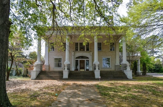


Property Detail
2900 Rogers Ave
18883-0000-00623-00
PART SW SW
Transientlodging
Sebastian
B and X Area of moderate flood hazard, usually the area between the limits of the 100-year and 500-year floods.
Arkansas
2025
1.10 AC
2025
Fort Smith/Russellville I-40
000800
Fort Smith
6,602 SF
Fort Smith, AR-OK
NEARBY LISTINGS FOR SALE OR LEASE
-
-
View all Fort Smith listings for sale on LoopNet.com
DEMOGRAPHICS near 2900 Rogers Ave
1 mile
3 mile
5 mile
2025 Total Population
12,313
57,891
79,827
2030 Population
12,613
58,877
81,050
Pop Growth 2025-2030
+ 2.44%
+ 1.70%
+ 1.53%
Average Age
39
39
39
2025 Total Households
5,267
23,428
32,158
HH Growth 2025-2030
+ 2.45%
+ 1.69%
+ 1.52%
Median Household Inc
$46,969
$47,655
$51,645
Avg Household Size
2.20
2.30
2.30
2025 Avg HH Vehicles
2.00
2.00
2.00
Median Home Value
$160,319
$156,837
$166,569
Median Year Built
1958
1969
1972
Nearby Places
Map Layers
Map Styles
 Street
 Aerial
Layers
 Traffic
 Biking
Places
Listings with unknown addresses are not visible on the map
- Restaurants
- Banks
- Shops
- Fitness
- Groceries
PUBLIC TRANSPORTATION
AIRPORT
Fort Smith Regional
Drive
Walk
Distance
Fort Smith Regional
13 min
4.3 mi
SALE & LEASE HISTORY
LISTING DATE
SALE/LEASE

Sep 13, 2021
For Sale
Mar 07, 2022
For Sale
Apr 29, 2021
For Sale
Nearby Properties
Address
Land Use
TOTAL SIZE
Lot Size
Zoning
Address
Land Use
TOTAL SIZE
Lot Size
Zoning
34,852 SF
17.68 AC
Address
Land Use
TOTAL SIZE
Lot Size
Zoning
53,104 SF
7.29 AC
Address
Land Use
TOTAL SIZE
Lot Size
Zoning
276,870 SF
36.85 AC
Address
Land Use
TOTAL SIZE
Lot Size
Zoning
138,906 SF
9.52 AC
Address
Land Use
TOTAL SIZE
Lot Size
Zoning
154,417 SF
8.08 AC
Address
Land Use
TOTAL SIZE
Lot Size
Zoning
198,302 SF
42.39 AC
Address
Land Use
TOTAL SIZE
Lot Size
Zoning
275,083 SF
11.29 AC
Address
Land Use
TOTAL SIZE
Lot Size
Zoning
178,951 SF
1.92 AC
Address
Land Use
TOTAL SIZE
Lot Size
Zoning
202,092 SF
16.25 AC
Address
Land Use
TOTAL SIZE
Lot Size
Zoning
67,084 SF
0.62 AC
Address
Land Use
TOTAL SIZE
Lot Size
Zoning
49,702 SF
1.36 AC
Address
Land Use
TOTAL SIZE
Lot Size
Zoning
237,553 SF
15.38 AC
Address
Land Use
TOTAL SIZE
Lot Size
Zoning
59,096 SF
21.97 AC
Address
Land Use
TOTAL SIZE
Lot Size
Zoning
936,618 SF
53.06 AC
Address
Land Use
TOTAL SIZE
Lot Size
Zoning
60,146 SF
0.81 AC
Address
Land Use
TOTAL SIZE
Lot Size
Zoning
125,968 SF
9.46 AC
Address
Land Use
TOTAL SIZE
Lot Size
Zoning
108,519 SF
13.38 AC
Address
Land Use
TOTAL SIZE
Lot Size
Zoning
54,697 SF
7.87 AC
Address
Land Use
TOTAL SIZE
Lot Size
Zoning
165,245 SF
15.39 AC
Address
Land Use
TOTAL SIZE
Lot Size
Zoning
94,409 SF
2.81 AC
Address
Land Use
TOTAL SIZE
Lot Size
Zoning
71,047 SF
0.45 AC
Address
Land Use
TOTAL SIZE
Lot Size
Zoning
18,492 SF
2.03 AC
Address
Land Use
TOTAL SIZE
Lot Size
Zoning
85,735 SF
2.28 AC
Address
Land Use
TOTAL SIZE
Lot Size
Zoning
6,643 SF
0.96 AC
Address
Land Use
TOTAL SIZE
Lot Size
Zoning
97,142 SF
3.96 AC
Address
Land Use
TOTAL SIZE
Lot Size
Zoning
130,669 SF
8.29 AC
Address
Land Use
TOTAL SIZE
Lot Size
Zoning
74,434 SF
8.63 AC
Address
Land Use
TOTAL SIZE
Lot Size
Zoning
108,000 SF
16.12 AC
Address
Land Use
TOTAL SIZE
Lot Size
Zoning
61,902 SF
6.53 AC
Address
Land Use
TOTAL SIZE
Lot Size
Zoning
99,151 SF
7.70 AC
The World's #1 Commercial Real Estate Marketplace
Connect with us
© 2026 CoStar Group
The information above has been obtained from sources believed reliable. While we do not doubt its accuracy we have not verified it and make no guarantee, warranty or representation about it. It is your responsibility to independently confirm its accuracy and completeness. Any projections, opinions, assumptions, or estimates used are for example only and do not represent the current or future performance of the property. The value of this transaction to you depends on tax and other factors which should be evaluated by your tax, financial, and legal advisors. You and your advisors should conduct a careful, independent investigation of the property to determine to your satisfaction the suitability of the property for your needs.