Property Record
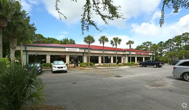
2900 Thomas Dr, Panama City, FL 32408


Property Detail
2900 Thomas Dr
31144-010-010
PORT LAGOON (1.04) 69C4 LOTS 1, 2, 12, 13 & PART OF LOTS 14 & 22 BLK 3 DESC AS: COM AT MOST SELY COR LOT 1 ALSO BEING INTERSECT OF NWLY R/W OF DANIEL ST & WLY R/W THOMAS DR FOR POB TH SWLY ALG DANIEL ST 191.22 TO INTER SECT WITH N R/W N LAGOON DR TH
Regionalshoppingcenterormallwithanchorstore
Bay
BC05
Florida
AE The base floodplain where base flood elevations are provided. AE Zones are now used on new format FIRMs instead of A1-A30 Zones.
1,14
2024
1.45 AC
2025
Panama City
002604
Other Market Areas
15,204 SF
Panama City-Panama City Beach, FL
NEARBY LISTINGS FOR SALE OR LEASE
DEMOGRAPHICS near 2900 Thomas Dr
1 mile
3 mile
5 mile
2025 Total Population
8,664
27,493
55,185
2030 Population
10,147
31,674
63,355
Pop Growth 2025-2030
+ 17.12%
+ 15.21%
+ 14.80%
Average Age
46
44
43
2025 Total Households
4,064
12,345
24,565
HH Growth 2025-2030
+ 17.57%
+ 15.89%
+ 15.58%
Median Household Inc
$79,428
$76,542
$71,062
Avg Household Size
2.10
2.20
2.20
2025 Avg HH Vehicles
2.00
2.00
2.00
Median Home Value
$374,302
$383,565
$370,954
Median Year Built
1989
1993
1993
Nearby Places
Map Layers
Map Styles
 Street
 Aerial
Layers
 Traffic
 Biking
Places
Listings with unknown addresses are not visible on the map
- Restaurants
- Banks
- Shops
- Fitness
- Groceries
PUBLIC TRANSPORTATION
AIRPORT
Northwest Florida Beaches International
Drive
Walk
Distance
Northwest Florida Beaches International
37 min
22.9 mi
Freight Ports
Port of Panama City
Drive
Walk
Distance
Port of Panama City
9 min
4.5 mi
SALE & LEASE HISTORY
LISTING DATE
SALE/LEASE

Sep 25, 2016
For Lease
Sep 21, 2020
For Lease
Mar 20, 2019
For Sale
Nearby Properties
Address
Land Use
TOTAL SIZE
Lot Size
Zoning
Address
Land Use
TOTAL SIZE
Lot Size
Zoning
96 AC
BC14
Address
Land Use
TOTAL SIZE
Lot Size
Zoning
68 AC
BC14
Address
Land Use
TOTAL SIZE
Lot Size
Zoning
176.88 AC
BC14
Address
Land Use
TOTAL SIZE
Lot Size
Zoning
287 AC
BC10
Address
Land Use
TOTAL SIZE
Lot Size
Zoning
335,150 SF
17.17 AC
BC05
Address
Land Use
TOTAL SIZE
Lot Size
Zoning
285,798 SF
16.50 AC
BC19
Address
Land Use
TOTAL SIZE
Lot Size
Zoning
648,279 SF
73.10 AC
PC14
Address
Land Use
TOTAL SIZE
Lot Size
Zoning
503,491 SF
79.46 AC
PC12
Address
Land Use
TOTAL SIZE
Lot Size
Zoning
40,690 SF
24.86 AC
BC19
Address
Land Use
TOTAL SIZE
Lot Size
Zoning
38,884 SF
149 AC
BC10
Address
Land Use
TOTAL SIZE
Lot Size
Zoning
254,904 SF
20.60 AC
BC05
Address
Land Use
TOTAL SIZE
Lot Size
Zoning
210,652 SF
19.47 AC
BC19
Address
Land Use
TOTAL SIZE
Lot Size
Zoning
84.50 AC
BC10
Address
Land Use
TOTAL SIZE
Lot Size
Zoning
206,450 SF
12.52 AC
BC05
Address
Land Use
TOTAL SIZE
Lot Size
Zoning
56,045 SF
2.82 AC
BC05
Address
Land Use
TOTAL SIZE
Lot Size
Zoning
43,287 SF
7.73 AC
BC04
Address
Land Use
TOTAL SIZE
Lot Size
Zoning
22,462 SF
1.99 AC
BC05
Address
Land Use
TOTAL SIZE
Lot Size
Zoning
112,780 SF
20.85 AC
BC14
Address
Land Use
TOTAL SIZE
Lot Size
Zoning
143,993 SF
7.27 AC
BC05
Address
Land Use
TOTAL SIZE
Lot Size
Zoning
50,377 SF
1.88 AC
BC05
Address
Land Use
TOTAL SIZE
Lot Size
Zoning
55 AC
BC14
Address
Land Use
TOTAL SIZE
Lot Size
Zoning
54 AC
BC10
Address
Land Use
TOTAL SIZE
Lot Size
Zoning
49,004 SF
6.85 AC
PCB21
Address
Land Use
TOTAL SIZE
Lot Size
Zoning
104,254 SF
2.20 AC
BC05
Address
Land Use
TOTAL SIZE
Lot Size
Zoning
49.47 AC
BC14
Address
Land Use
TOTAL SIZE
Lot Size
Zoning
100,607 SF
12.14 AC
BC05
Address
Land Use
TOTAL SIZE
Lot Size
Zoning
Address
Land Use
TOTAL SIZE
Lot Size
Zoning
41 AC
BC14
Address
Land Use
TOTAL SIZE
Lot Size
Zoning
153,484 SF
1.92 AC
PC14
Address
Land Use
TOTAL SIZE
Lot Size
Zoning
37 AC
BC14
The World's #1 Commercial Real Estate Marketplace
Connect with us
© 2026 CoStar Group
The information above has been obtained from sources believed reliable. While we do not doubt its accuracy we have not verified it and make no guarantee, warranty or representation about it. It is your responsibility to independently confirm its accuracy and completeness. Any projections, opinions, assumptions, or estimates used are for example only and do not represent the current or future performance of the property. The value of this transaction to you depends on tax and other factors which should be evaluated by your tax, financial, and legal advisors. You and your advisors should conduct a careful, independent investigation of the property to determine to your satisfaction the suitability of the property for your needs.