Property Record
2901 Burnt Store Rd N, Cape Coral, FL 33993
This Property Is For Sale
NEARBY LISTINGS FOR SALE OR LEASE
Property Detail
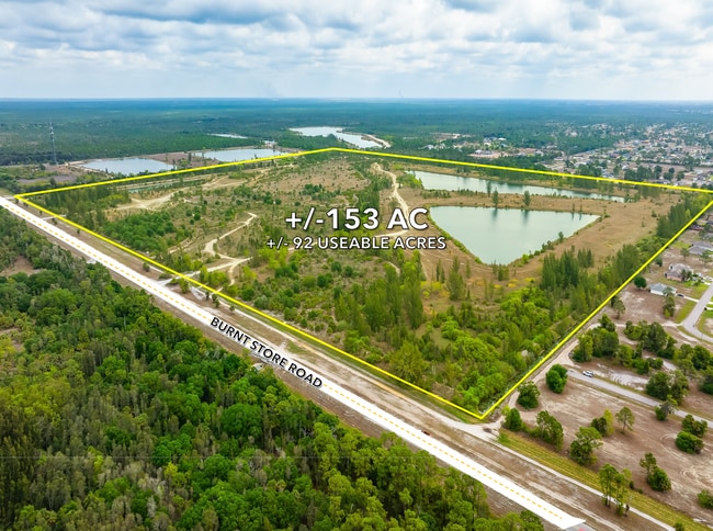
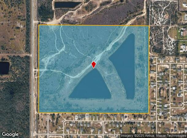
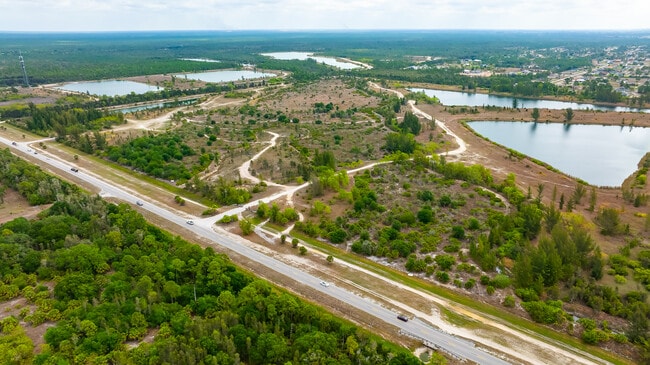
2901 Burnt Store Rd N
Cape Coral-Fort Myers, FL
Cape Coral Units 98 & 98 Part 1
29-43-23-C1-00001.0020
N 1/2 OF W 1/2 LESS WLY 132 FT LESS PARCEL 1 003
Commercialacreage
Lee
AE
Florida
12071C0233G
2
2024
114.94 AC
2025
Cape Coral
010113
Southwest Florida
DEMOGRAPHICS near 2901 Burnt Store Rd N
1 Mile
3 Mile
5 Mile
2024 Total Population
1,494
18,898
54,902
2029 Population
1,829
22,950
66,595
Pop Growth 2024-2029
+ 22.42%
+ 21.44%
+ 21.30%
Average Age
39
40
41
2024 Total Households
495
6,520
19,143
HH Growth 2024-2029
+ 22.02%
+ 21.09%
+ 20.98%
Median Household Inc
$84,005
$79,861
$75,637
Avg Household Size
2.90
2.80
2.80
2024 Avg HH Vehicles
2.00
2.00
2.00
Median Home Value
$209,317
$277,541
$277,798
Median Year Built
2008
2007
2006
Nearby Places
Map Layers
Map Styles
 Street
 Aerial
- Restaurants
- Banks
- Shops
- Fitness
- Groceries
PUBLIC TRANSPORTATION
AIRPORT
Punta Gorda
DRIVE
WALK
Distance
Punta Gorda
27 min
17.1 mi
Southwest Florida International
DRIVE
WALK
Distance
Southwest Florida International
48 min
30.0 mi
Freight Ports
Port Manatee
DRIVE
WALK
Distance
Port Manatee
108 min
88.8 mi
Nearby Properties
Address
Land Use
TOTAL SIZE
Lot Size
Zoning
Address
Land Use
TOTAL SIZE
Lot Size
Zoning
670.48 AC
AG-2
Address
Land Use
TOTAL SIZE
Lot Size
Zoning
71,898 SF
98.60 AC
C1-D
Address
Land Use
TOTAL SIZE
Lot Size
Zoning
303.23 AC
AG-2
Address
Land Use
TOTAL SIZE
Lot Size
Zoning
255.79 AC
AG-2
Address
Land Use
TOTAL SIZE
Lot Size
Zoning
228.33 AC
R1A
Address
Land Use
TOTAL SIZE
Lot Size
Zoning
78,740 SF
4.51 AC
C-1
Address
Land Use
TOTAL SIZE
Lot Size
Zoning
142.97 AC
AG-2
Address
Land Use
TOTAL SIZE
Lot Size
Zoning
113.70 AC
AG-2
Address
Land Use
TOTAL SIZE
Lot Size
Zoning
8,068 SF
1.10 AC
C-1
Address
Land Use
TOTAL SIZE
Lot Size
Zoning
3.87 AC
PRFLU
Address
Land Use
TOTAL SIZE
Lot Size
Zoning
6.73 AC
C-1
Address
Land Use
TOTAL SIZE
Lot Size
Zoning
8,898 SF
2.95 AC
NC
Address
Land Use
TOTAL SIZE
Lot Size
Zoning
23,747 SF
178.18 AC
Address
Land Use
TOTAL SIZE
Lot Size
Zoning
157.25 AC
AG-2
Address
Land Use
TOTAL SIZE
Lot Size
Zoning
19.27 AC
AG-2
Address
Land Use
TOTAL SIZE
Lot Size
Zoning
19 AC
AG-2
Address
Land Use
TOTAL SIZE
Lot Size
Zoning
3.71 AC
R1-W
Address
Land Use
TOTAL SIZE
Lot Size
Zoning
20.30 AC
RD-D
Address
Land Use
TOTAL SIZE
Lot Size
Zoning
102.92 AC
A
Address
Land Use
TOTAL SIZE
Lot Size
Zoning
19.05 AC
R1
Address
Land Use
TOTAL SIZE
Lot Size
Zoning
20.24 AC
AG-2
Address
Land Use
TOTAL SIZE
Lot Size
Zoning
38.54 AC
AG-2
Address
Land Use
TOTAL SIZE
Lot Size
Zoning
38.18 AC
C1-D
Address
Land Use
TOTAL SIZE
Lot Size
Zoning
0.23 AC
R1-W
Address
Land Use
TOTAL SIZE
Lot Size
Zoning
15.83 AC
INS
Address
Land Use
TOTAL SIZE
Lot Size
Zoning
6,613 SF
1.18 AC
RD-W
Address
Land Use
TOTAL SIZE
Lot Size
Zoning
9.31 AC
RE
Address
Land Use
TOTAL SIZE
Lot Size
Zoning
20 AC
R1
Address
Land Use
TOTAL SIZE
Lot Size
Zoning
20.46 AC
INST
The World's #1 Commercial Real Estate Marketplace
Connect with us
© 2026 CoStar Group
The information above has been obtained from sources believed reliable. While we do not doubt its accuracy we have not verified it and make no guarantee, warranty or representation about it. It is your responsibility to independently confirm its accuracy and completeness. Any projections, opinions, assumptions, or estimates used are for example only and do not represent the current or future performance of the property. The value of this transaction to you depends on tax and other factors which should be evaluated by your tax, financial, and legal advisors. You and your advisors should conduct a careful, independent investigation of the property to determine to your satisfaction the suitability of the property for your needs.