Property Record
2901 E 114Th St, Kansas City, MO 64137
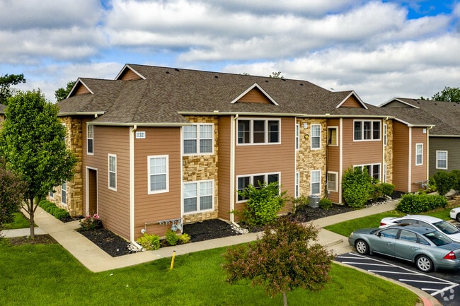

Property Detail
2901 E 114Th St
64-330-04-10-00-0-00-000
RED BRIDGE LAKES 2ND PLAT---TRACT B
Apartment
JACKSON
B and X Area of moderate flood hazard, usually the area between the limits of the 100-year and 500-year floods.
Missouri
2024
23.60 AC
2025
Calico Farms
010203
Kansas City
23,164 SF
Kansas City, MO-KS
NEARBY LISTINGS FOR SALE OR LEASE
-
-
View all Kansas City listings for sale on LoopNet.com
DEMOGRAPHICS near 2901 E 114Th St
1 mile
3 mile
5 mile
2025 Total Population
4,684
52,223
144,768
2030 Population
4,692
52,652
146,792
Pop Growth 2025-2030
+ 0.17%
+ 0.82%
+ 1.40%
Average Age
39
40
40
2025 Total Households
1,990
23,249
61,677
HH Growth 2025-2030
+ 0.10%
+ 0.74%
+ 1.38%
Median Household Inc
$69,196
$59,657
$71,510
Avg Household Size
2.20
2.10
2.30
2025 Avg HH Vehicles
2.00
2.00
2.00
Median Home Value
$185,982
$226,703
$264,050
Median Year Built
1966
1971
1970
Nearby Places
Map Layers
Map Styles
 Street
 Aerial
Layers
 Traffic
 Biking
Places
Listings with unknown addresses are not visible on the map
- Restaurants
- Banks
- Shops
- Fitness
- Groceries
PUBLIC TRANSPORTATION
AIRPORT
Kansas City International
Drive
Walk
Distance
Kansas City International
51 min
35.6 mi
Freight Ports
Tulsa Port Of Catoosa
Drive
Walk
Distance
Tulsa Port Of Catoosa
260 min
228.6 mi
Nearby Properties
Address
Land Use
TOTAL SIZE
Lot Size
Zoning
Address
Land Use
TOTAL SIZE
Lot Size
Zoning
59,570 SF
8.46 AC
SD-O
Address
Land Use
TOTAL SIZE
Lot Size
Zoning
436,499 SF
22.71 AC
Address
Land Use
TOTAL SIZE
Lot Size
Zoning
387,197 SF
Address
Land Use
TOTAL SIZE
Lot Size
Zoning
457,500 SF
Address
Land Use
TOTAL SIZE
Lot Size
Zoning
157,280 SF
25.10 AC
Address
Land Use
TOTAL SIZE
Lot Size
Zoning
547,629 SF
62.41 AC
Address
Land Use
TOTAL SIZE
Lot Size
Zoning
270,862 SF
27.39 AC
Address
Land Use
TOTAL SIZE
Lot Size
Zoning
60,960 SF
4.82 AC
SD-NCR
Address
Land Use
TOTAL SIZE
Lot Size
Zoning
89,709 SF
13.43 AC
Address
Land Use
TOTAL SIZE
Lot Size
Zoning
431,078 SF
Address
Land Use
TOTAL SIZE
Lot Size
Zoning
202,498 SF
Address
Land Use
TOTAL SIZE
Lot Size
Zoning
875,807 SF
49.32 AC
Address
Land Use
TOTAL SIZE
Lot Size
Zoning
355,091 SF
41.50 AC
Address
Land Use
TOTAL SIZE
Lot Size
Zoning
237,884 SF
0.77 AC
Address
Land Use
TOTAL SIZE
Lot Size
Zoning
114,669 SF
8.43 AC
SD-CR
Address
Land Use
TOTAL SIZE
Lot Size
Zoning
140,970 SF
7.88 AC
Address
Land Use
TOTAL SIZE
Lot Size
Zoning
33,096 SF
Address
Land Use
TOTAL SIZE
Lot Size
Zoning
628,134 SF
37.62 AC
Address
Land Use
TOTAL SIZE
Lot Size
Zoning
180,271 SF
21.60 AC
Address
Land Use
TOTAL SIZE
Lot Size
Zoning
35,850 SF
41.30 AC
Address
Land Use
TOTAL SIZE
Lot Size
Zoning
69,818 SF
5.57 AC
Address
Land Use
TOTAL SIZE
Lot Size
Zoning
112,712 SF
6.22 AC
Address
Land Use
TOTAL SIZE
Lot Size
Zoning
122,298 SF
5.54 AC
Address
Land Use
TOTAL SIZE
Lot Size
Zoning
117,358 SF
3.80 AC
Address
Land Use
TOTAL SIZE
Lot Size
Zoning
15,528 SF
2.50 AC
Address
Land Use
TOTAL SIZE
Lot Size
Zoning
85,513 SF
9.10 AC
SD-CR
Address
Land Use
TOTAL SIZE
Lot Size
Zoning
485,993 SF
22.35 AC
Address
Land Use
TOTAL SIZE
Lot Size
Zoning
71,685 SF
10.60 AC
Address
Land Use
TOTAL SIZE
Lot Size
Zoning
166,384 SF
27.90 AC
Address
Land Use
TOTAL SIZE
Lot Size
Zoning
170,273 SF
12.68 AC
The World's #1 Commercial Real Estate Marketplace
Connect with us
© 2026 CoStar Group
The information above has been obtained from sources believed reliable. While we do not doubt its accuracy we have not verified it and make no guarantee, warranty or representation about it. It is your responsibility to independently confirm its accuracy and completeness. Any projections, opinions, assumptions, or estimates used are for example only and do not represent the current or future performance of the property. The value of this transaction to you depends on tax and other factors which should be evaluated by your tax, financial, and legal advisors. You and your advisors should conduct a careful, independent investigation of the property to determine to your satisfaction the suitability of the property for your needs.