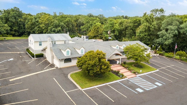
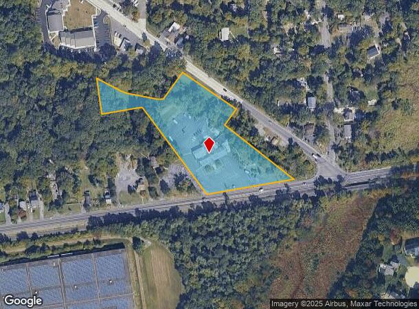
Property Record
2901 Marne Hwy, Mount Laurel, NJ 08054

NEARBY LISTINGS FOR SALE OR LEASE
Property Detail
2901 Marne Hwy
24-00205-01-00002
2 AC LOW/WET GBA:9497
Restaurantbuilding
Burlington
X
New Jersey
34005C0251F
2
2024
4.19 AC
2025
South Burlington County
702914
Philadelphia
9,497 SF
Philadelphia-Camden-Wilmington, PA-NJ-DE-MD
DEMOGRAPHICS near 2901 Marne Hwy
1 Mile
3 Mile
5 Mile
2024 Total Population
7,660
39,784
132,980
2029 Population
7,812
40,506
135,658
Pop Growth 2024-2029
+ 1.98%
+ 1.81%
+ 2.01%
Average Age
44
42
42
2024 Total Households
3,290
16,001
50,449
HH Growth 2024-2029
+ 1.82%
+ 1.67%
+ 2.01%
Median Household Inc
$98,468
$108,709
$102,218
Avg Household Size
2.30
2.40
2.60
2024 Avg HH Vehicles
2.00
2.00
2.00
Median Home Value
$304,798
$302,874
$292,136
Median Year Built
1990
1986
1981
Nearby Places
Map Layers
Map Styles
 Street
 Aerial
- Restaurants
- Banks
- Shops
- Fitness
- Groceries
PUBLIC TRANSPORTATION
AIRPORT
Trenton Mercer
DRIVE
WALK
Distance
Trenton Mercer
42 min
28.5 mi
Philadelphia International
DRIVE
WALK
Distance
Philadelphia International
44 min
29.6 mi
Freight Ports
Port of Philadelphia
DRIVE
WALK
Distance
Port of Philadelphia
29 min
15.0 mi
SALE & LEASE HISTORY
LISTING DATE
SALE/LEASE

Mar 24, 2017
For Sale
Jun 15, 2017
For Sale
Jul 18, 2017
For Sale
Feb 05, 2018
For Sale
Aug 27, 2018
For Lease
Aug 27, 2018
For Sale
Nearby Properties
Address
Land Use
TOTAL SIZE
Lot Size
Zoning
Address
Land Use
TOTAL SIZE
Lot Size
Zoning
39.71 AC
Address
Land Use
TOTAL SIZE
Lot Size
Zoning
40.92 AC
Address
Land Use
TOTAL SIZE
Lot Size
Zoning
74.17 AC
BRMF
Address
Land Use
TOTAL SIZE
Lot Size
Zoning
14.15 AC
Address
Land Use
TOTAL SIZE
Lot Size
Zoning
97,993 SF
63.75 AC
Address
Land Use
TOTAL SIZE
Lot Size
Zoning
30.76 AC
R-9
Address
Land Use
TOTAL SIZE
Lot Size
Zoning
25.84 AC
Address
Land Use
TOTAL SIZE
Lot Size
Zoning
53.05 AC
I2
Address
Land Use
TOTAL SIZE
Lot Size
Zoning
25.58 AC
Address
Land Use
TOTAL SIZE
Lot Size
Zoning
999,999,999 SF
88.63 AC
Address
Land Use
TOTAL SIZE
Lot Size
Zoning
8.31 AC
Address
Land Use
TOTAL SIZE
Lot Size
Zoning
682,707 SF
Address
Land Use
TOTAL SIZE
Lot Size
Zoning
478,715 SF
35.19 AC
Address
Land Use
TOTAL SIZE
Lot Size
Zoning
Address
Land Use
TOTAL SIZE
Lot Size
Zoning
15.69 AC
Address
Land Use
TOTAL SIZE
Lot Size
Zoning
19.79 AC
Address
Land Use
TOTAL SIZE
Lot Size
Zoning
30.84 AC
Address
Land Use
TOTAL SIZE
Lot Size
Zoning
Address
Land Use
TOTAL SIZE
Lot Size
Zoning
2,704 SF
28.75 AC
Address
Land Use
TOTAL SIZE
Lot Size
Zoning
Address
Land Use
TOTAL SIZE
Lot Size
Zoning
190,000 SF
22.17 AC
Address
Land Use
TOTAL SIZE
Lot Size
Zoning
23.76 AC
Address
Land Use
TOTAL SIZE
Lot Size
Zoning
Address
Land Use
TOTAL SIZE
Lot Size
Zoning
Address
Land Use
TOTAL SIZE
Lot Size
Zoning
Address
Land Use
TOTAL SIZE
Lot Size
Zoning
45.64 AC
Address
Land Use
TOTAL SIZE
Lot Size
Zoning
26.87 AC
Address
Land Use
TOTAL SIZE
Lot Size
Zoning
12.90 AC
Address
Land Use
TOTAL SIZE
Lot Size
Zoning
25,000 SF
27.67 AC
Address
Land Use
TOTAL SIZE
Lot Size
Zoning
13.58 AC
The World's #1 Commercial Real Estate Marketplace
Connect with us
© 2025 CoStar Group
The information above has been obtained from sources believed reliable. While we do not doubt its accuracy we have not verified it and make no guarantee, warranty or representation about it. It is your responsibility to independently confirm its accuracy and completeness. Any projections, opinions, assumptions, or estimates used are for example only and do not represent the current or future performance of the property. The value of this transaction to you depends on tax and other factors which should be evaluated by your tax, financial, and legal advisors. You and your advisors should conduct a careful, independent investigation of the property to determine to your satisfaction the suitability of the property for your needs.