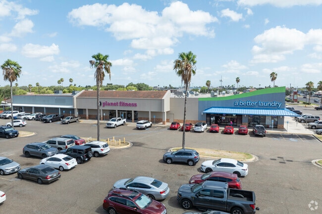
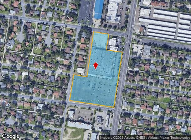
Property Record
2901 N 23Rd St, Mcallen, TX 78501
NEARBY LISTINGS FOR SALE OR LEASE
Property Detail
2901 N 23Rd St
McAllen/Edinburg/Pharr
Wal-Mart - Sml
McAllen-Edinburg-Mission, TX
WAL-MART LOT A
W0255-00-000-000A-00
Hidalgo
Commercialnec
Texas
2024
a
2025
6.73 AC
020725
Greater McAllen
76,560 SF
DEMOGRAPHICS near 2901 N 23Rd St
1 Mile
3 Mile
5 Mile
2024 Total Population
17,762
113,490
246,640
2029 Population
18,506
119,617
261,228
Pop Growth 2024-2029
+ 4.19%
+ 5.40%
+ 5.91%
Average Age
36
37
36
2024 Total Households
6,117
39,264
82,595
HH Growth 2024-2029
+ 3.97%
+ 5.29%
+ 5.94%
Median Household Inc
$48,843
$52,922
$52,082
Avg Household Size
2.80
2.80
2.90
2024 Avg HH Vehicles
2.00
2.00
2.00
Median Home Value
$146,515
$159,906
$156,109
Median Year Built
1986
1992
1996
Nearby Places
Map Layers
Map Styles
 Street
 Aerial
- Restaurants
- Banks
- Shops
- Fitness
- Groceries
PUBLIC TRANSPORTATION
AIRPORT
McAllen International
DRIVE
WALK
Distance
McAllen International
9 min
4.5 mi
Freight Ports
Port of Brownsville
DRIVE
WALK
Distance
Port of Brownsville
72 min
61.3 mi
SALE & LEASE HISTORY
LISTING DATE
SALE/LEASE

Oct 04, 2021
For Sale
Jun 18, 2018
For Lease
Jan 31, 2022
For Sale
Feb 15, 2018
For Lease
Dec 20, 2022
For Lease
Aug 16, 2019
For Sale
Apr 11, 2017
For Lease
Nearby Properties
Address
Land Use
TOTAL SIZE
Lot Size
Zoning
Address
Land Use
TOTAL SIZE
Lot Size
Zoning
407,190 SF
11.04 AC
CO
Address
Land Use
TOTAL SIZE
Lot Size
Zoning
357,818 SF
11.10 AC
Address
Land Use
TOTAL SIZE
Lot Size
Zoning
165,620 SF
24.44 AC
Address
Land Use
TOTAL SIZE
Lot Size
Zoning
93,471 SF
12.66 AC
Address
Land Use
TOTAL SIZE
Lot Size
Zoning
18 SF
82.24 AC
Address
Land Use
TOTAL SIZE
Lot Size
Zoning
354,558 SF
26.79 AC
Address
Land Use
TOTAL SIZE
Lot Size
Zoning
263,388 SF
37.48 AC
Address
Land Use
TOTAL SIZE
Lot Size
Zoning
235,545 SF
40.51 AC
Address
Land Use
TOTAL SIZE
Lot Size
Zoning
191,978 SF
2.22 AC
Address
Land Use
TOTAL SIZE
Lot Size
Zoning
252,435 SF
9.09 AC
Address
Land Use
TOTAL SIZE
Lot Size
Zoning
208,941 SF
18.57 AC
Address
Land Use
TOTAL SIZE
Lot Size
Zoning
159,617 SF
5.38 AC
Address
Land Use
TOTAL SIZE
Lot Size
Zoning
128,076 SF
5.01 AC
Address
Land Use
TOTAL SIZE
Lot Size
Zoning
125,254 SF
15 AC
C
Address
Land Use
TOTAL SIZE
Lot Size
Zoning
254,477 SF
51.88 AC
Address
Land Use
TOTAL SIZE
Lot Size
Zoning
79,150 SF
10.24 AC
Address
Land Use
TOTAL SIZE
Lot Size
Zoning
208,113 SF
22.75 AC
Address
Land Use
TOTAL SIZE
Lot Size
Zoning
173,217 SF
5.58 AC
Address
Land Use
TOTAL SIZE
Lot Size
Zoning
3,000 SF
16 AC
Address
Land Use
TOTAL SIZE
Lot Size
Zoning
121,353 SF
4.59 AC
Address
Land Use
TOTAL SIZE
Lot Size
Zoning
115,360 SF
4.70 AC
Address
Land Use
TOTAL SIZE
Lot Size
Zoning
16.83 AC
CO
Address
Land Use
TOTAL SIZE
Lot Size
Zoning
108,527 SF
1.49 AC
Address
Land Use
TOTAL SIZE
Lot Size
Zoning
92,603 SF
7.10 AC
CO
Address
Land Use
TOTAL SIZE
Lot Size
Zoning
1 SF
7.79 AC
Address
Land Use
TOTAL SIZE
Lot Size
Zoning
1 SF
37.01 AC
Address
Land Use
TOTAL SIZE
Lot Size
Zoning
82,724 SF
3.27 AC
Address
Land Use
TOTAL SIZE
Lot Size
Zoning
59,816 SF
2.42 AC
Address
Land Use
TOTAL SIZE
Lot Size
Zoning
82,448 SF
4.36 AC
Address
Land Use
TOTAL SIZE
Lot Size
Zoning
95,245 SF
8.92 AC
C-3
The World's #1 Commercial Real Estate Marketplace
Connect with us
© 2025 CoStar Group
The information above has been obtained from sources believed reliable. While we do not doubt its accuracy we have not verified it and make no guarantee, warranty or representation about it. It is your responsibility to independently confirm its accuracy and completeness. Any projections, opinions, assumptions, or estimates used are for example only and do not represent the current or future performance of the property. The value of this transaction to you depends on tax and other factors which should be evaluated by your tax, financial, and legal advisors. You and your advisors should conduct a careful, independent investigation of the property to determine to your satisfaction the suitability of the property for your needs.