Property Record
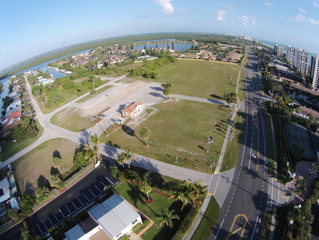
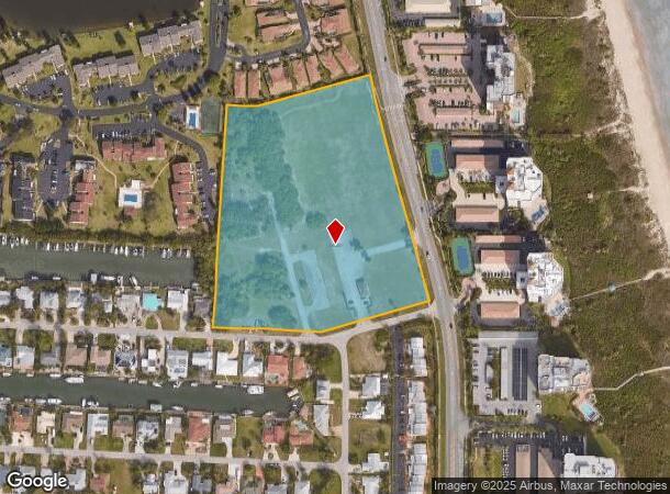
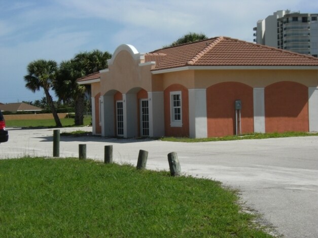
2901 N Highway A1a, Hutchinson Island, FL 34949
NEARBY LISTINGS FOR SALE OR LEASE
Property Detail
2901 N Highway A1a
14-25-701-0153-0007
Coral Cove Beach Section 1
Officebuilding
CORAL COVE BEACH-SECTION ONE-TRACT A, E-1 AND F-1 AND ALL BLKS 8 AND 9 AND VAC ALLEY ADJ ON S OF BLK 8 AND VAC ALLEY ADJ ON N OF BLK 9 AS IN OR 2571-203 AND ALL OF VAC FLOTILLA TERR LYG N OF MARINA DR- (9.24 AC)
AE
St Lucie
12111C0181K
Florida
2024
9.44 AC
2025
St Lucie Coastal
381204
Port St Lucie/Fort Pierce
1,026 SF
Port St Lucie, FL
DEMOGRAPHICS near 2901 N Highway A1a
1 Mile
3 Mile
5 Mile
2024 Total Population
3,546
17,602
49,851
2029 Population
4,559
22,230
61,117
Pop Growth 2024-2029
+ 28.57%
+ 26.29%
+ 22.60%
Average Age
61
55
45
2024 Total Households
1,836
8,890
20,599
HH Growth 2024-2029
+ 28.21%
+ 26.19%
+ 23.03%
Median Household Inc
$74,888
$56,935
$44,791
Avg Household Size
1.90
1.90
2.30
2024 Avg HH Vehicles
2.00
1.00
1.00
Median Home Value
$490,547
$337,177
$279,332
Median Year Built
1996
1991
1980
Nearby Places
Map Layers
Map Styles
 Street
 Aerial
- Restaurants
- Banks
- Shops
- Fitness
- Groceries
SALE & LEASE HISTORY
LISTING DATE
SALE/LEASE

Sep 24, 2016
For Sale
Nearby Properties
Address
Land Use
TOTAL SIZE
Lot Size
Zoning
Address
Land Use
TOTAL SIZE
Lot Size
Zoning
3,240 SF
45.25 AC
INSTITUTIO
Address
Land Use
TOTAL SIZE
Lot Size
Zoning
11.78 AC
COMM RESOR
Address
Land Use
TOTAL SIZE
Lot Size
Zoning
13,280 SF
12.46 AC
GENERAL &
Address
Land Use
TOTAL SIZE
Lot Size
Zoning
17,273 SF
13.49 AC
GENERAL &
Address
Land Use
TOTAL SIZE
Lot Size
Zoning
14,800 SF
17.11 AC
INSTITUTIO
Address
Land Use
TOTAL SIZE
Lot Size
Zoning
7,708 SF
0.93 AC
TOURIST CO
Address
Land Use
TOTAL SIZE
Lot Size
Zoning
123.19 AC
HUTCH ISLA
Address
Land Use
TOTAL SIZE
Lot Size
Zoning
1,440 SF
28.47 AC
PUD
Address
Land Use
TOTAL SIZE
Lot Size
Zoning
6,622 SF
67.17 AC
INSTITUTIO
Address
Land Use
TOTAL SIZE
Lot Size
Zoning
1,000 SF
3.73 AC
GENERAL &
Address
Land Use
TOTAL SIZE
Lot Size
Zoning
23.21 AC
PUD
Address
Land Use
TOTAL SIZE
Lot Size
Zoning
12,517 SF
5.85 AC
GENERAL &
Address
Land Use
TOTAL SIZE
Lot Size
Zoning
65,440 SF
9.83 AC
GENERAL CO
Address
Land Use
TOTAL SIZE
Lot Size
Zoning
1,343 SF
5.33 AC
MARINE IND
Address
Land Use
TOTAL SIZE
Lot Size
Zoning
38,158 SF
4.10 AC
CG - CO
Address
Land Use
TOTAL SIZE
Lot Size
Zoning
4,956 SF
17.16 AC
GENERAL &
Address
Land Use
TOTAL SIZE
Lot Size
Zoning
52.31 AC
HUTCH ISLA
Address
Land Use
TOTAL SIZE
Lot Size
Zoning
504 SF
9.54 AC
INSTITUTIO
Address
Land Use
TOTAL SIZE
Lot Size
Zoning
576 SF
2.09 AC
GENERAL &
Address
Land Use
TOTAL SIZE
Lot Size
Zoning
7,620 SF
13.76 AC
MARINE COM
Address
Land Use
TOTAL SIZE
Lot Size
Zoning
2,820 SF
42.82 AC
TOURIST CO
Address
Land Use
TOTAL SIZE
Lot Size
Zoning
420 SF
171.31 AC
INSTITUTIO
Address
Land Use
TOTAL SIZE
Lot Size
Zoning
21,515 SF
2.64 AC
TOURIST CO
Address
Land Use
TOTAL SIZE
Lot Size
Zoning
45,387 SF
2.23 AC
C - VG
Address
Land Use
TOTAL SIZE
Lot Size
Zoning
7.45 AC
HUTCH ISLA
Address
Land Use
TOTAL SIZE
Lot Size
Zoning
10.39 AC
PUD
Address
Land Use
TOTAL SIZE
Lot Size
Zoning
14,491 SF
18.70 AC
GENERAL &
Address
Land Use
TOTAL SIZE
Lot Size
Zoning
1,468 SF
10.58 AC
PUD
Address
Land Use
TOTAL SIZE
Lot Size
Zoning
21.38 AC
PUD
The World's #1 Commercial Real Estate Marketplace
Connect with us
© 2025 CoStar Group
The information above has been obtained from sources believed reliable. While we do not doubt its accuracy we have not verified it and make no guarantee, warranty or representation about it. It is your responsibility to independently confirm its accuracy and completeness. Any projections, opinions, assumptions, or estimates used are for example only and do not represent the current or future performance of the property. The value of this transaction to you depends on tax and other factors which should be evaluated by your tax, financial, and legal advisors. You and your advisors should conduct a careful, independent investigation of the property to determine to your satisfaction the suitability of the property for your needs.